LoJ: #272 (Pre-LiDAR #275) / 13,481' Mount Ridgway S. 2

Peak Summary
This route accesses Whitehouse and Ridgway from out of the town of Ridgway and the north side of the range. Involves some significant route finding and bushwhacking but saves elevation gain compared to hiking from Ouray. Goes at Class 2+. Higher clearance vehicle is useful and will save significant mileage. Lidar measurements added 13 feet to Mt. Ridgway.
Mount Ridgway from Ridgway Hut Route
-
-
Upper Miller Mesa Trailhead
From the town of Ridgway, drive west on SH62 to the last street on the left you can turn onto (S. Amelia St.). Drive about 3 blocks south and turn right onto CR5. Drive on a graded dirt road about 5.3 more miles up onto Miller Mesa, Elk Meadows and an intersection. There's a large parking area. These are the coordinates provided above. Passenger cars should park here. Higher clearance vehicles may continue to what we'll call the "upper trailhead."
Continue walking or driving SSE on FR852. The road will round a low hill, cut back to the SW to an overlook of the Beaver Creek drainage, then cut back to the east and then SE. It will follow an old ditch and then drop south to a crossing of a fork of Coal Creek, where it switchbacks and rounds a low ridge. This is where it crosses onto Forest Service land at a gate. From the lower trailhead to the Forest Service boundary, it's 3.7 miles. Continue following the road as it turns south again another.4 mile to a place where it turns sharply east. Right here, there's some good camping. If you continue east at a fork here, the road leads up to the Burn Hut and our route for Corbett Ridge. Right where the road makes the turn to the east, there's a trail that heads off to the west up an embankment. This is the trail you want if climbing Whitehouse and Ridgway. If marked, it's called the "Dallas Trail" and on the Trails Illustrated map #141, its number is 200. Elevation here is 9,430 ft. Approximate coordinates are: N 38° 03' 26.03" W 107° 45' 08.46". These have not been field tested, so don't take them too literally. It's hard to find this spot on Google Earth, so prefer the driving/hiking directions over the coordinates if confused or in doubt. Last time we were here, the trail sign was knocked over and difficult to spot.
Camping
There are a few primitive spots along the 3.7 mile drive in on FR852 ( but you may be on private land) and at the upper trailhead location. Be careful regarding private property. You should be on National Forest land at the upper trailhead.
-
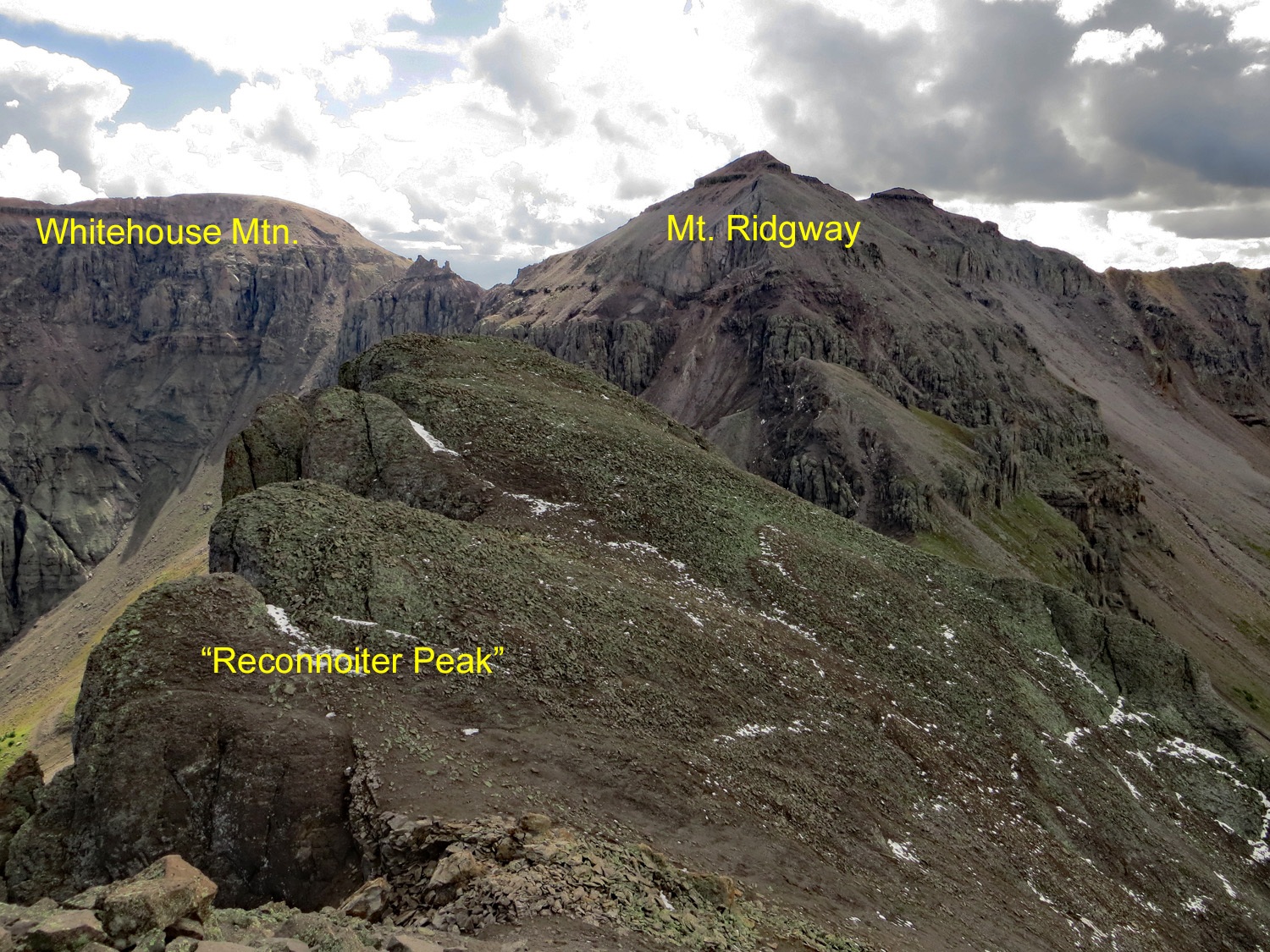
From Whitehouse Mountain
Click thumbnail to view full-size photo + caption
Open This Route in a New WindowIn our report, we have sequenced Mt. Ridgway with Whitehouse. Since they both largely use the same route for much of the way, you might as well do these two together, especially considering the bushwhacking effort you'll put in.
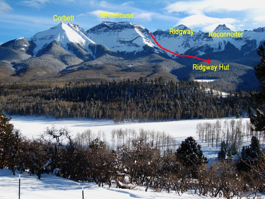
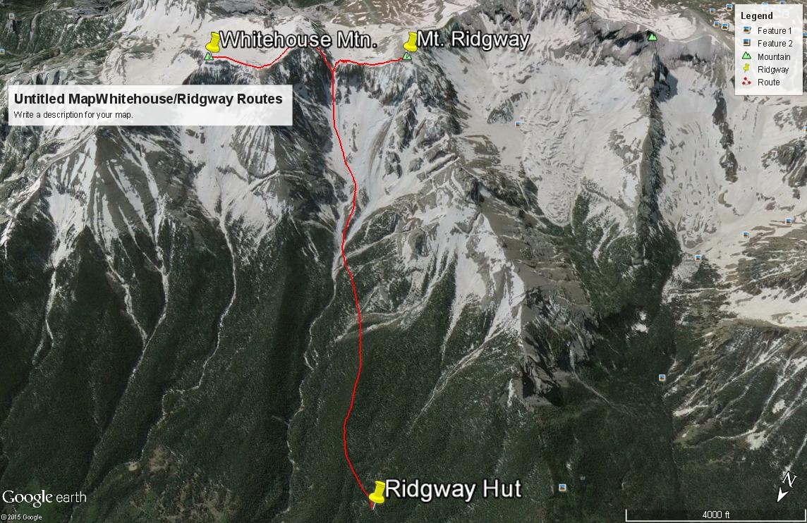
From the "upper" trailhead, hike NW up a hillside on the "Dallas" Trail #200 and contour around the nose of a tree-covered ridge. You'll then be heading SSW and will cross a minor creek drainage which is actually the west fork of Coal Creek you drove/hiked across earlier to reach the upper TH. After crossing, the trail turns NW again, rounds a broader ridge and turns SW and joins an old roadbed for a short distance. The trail then crosses Beaver Creek, heads up a small ridge, then crosses a minor tributary to Beaver Creek. Less than a half mile after crossing Beaver Creek, watch for the trail to head south and follow an old roadbed uphill. On the Trails Illustrated map #141, this is the Wilson Creek Trail #202 which will lead you up to the Ridgway Hut at 10,200 ft. On the Uncompahgre NF map, this remains trail #200. The main point is to get yourself to the Ridgway Hut at these coordinates: N 38° 02' 24.81" W 107° 46" 05.81". When we hiked this last section in 1998, we found an old roadbed that switch-backed multiple times as it led uphill to the hut. It's possible the trail along this section has now been revised because more recent maps do not show all the switchbacks. The climbing route will start from the hut.
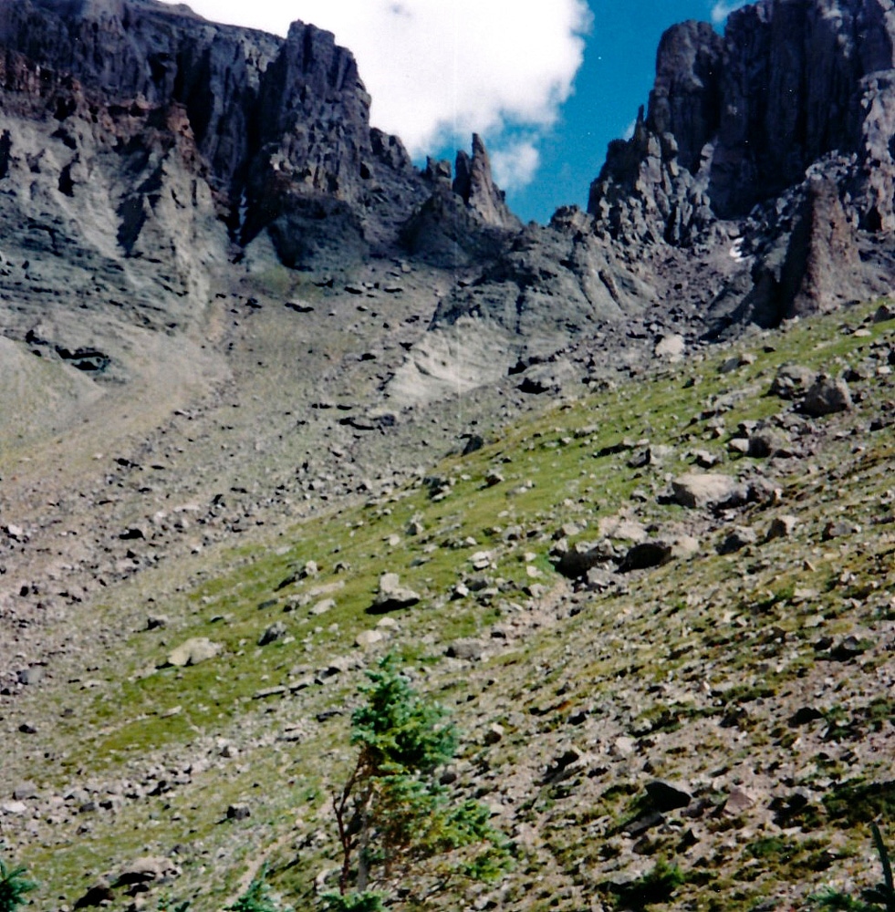
If you've made it to the Ridgway Hut, head SE from the hut, initially through some open forest and then into dense trees with enough fallen timber to look like a giant game of pick-up-sticks. It will look almost impossible to navigate but there are numerous game trails (elk mostly) that penetrate the fallen log maze and lead you to a ridge on the west side of Beaver Creek. Follow the ridge SSE utilizing the game trails as best you can. In about 3/4 mile, you'll need to drop a little and cross two open avalanche chutes a little below the 11,000 foot level. Any trail you may have been following will disappear here as dense vegetation obscures it and hidden obstacles like boulders and logs.
After tripping your way across the avalanche chutes, continue contouring SSE toward Beaver Creek and hopefully come out near where two minor drainages join in with the main flow at 11,000 ft. If you're alert, you may be able to find a clear game trail that will take you through this last section over to Beaver Creek. Head now for the main saddle between Whitehouse and Ridgway. Hike up a steep ridge between two stream courses that's mostly tundra with a few trees. If you're lucky and quiet, you may see some elk here. The open ridge is crisscrossed with their trails and you'll see areas they have leveled out for sleeping and ruminating. Continue up this ridge until it plays out.
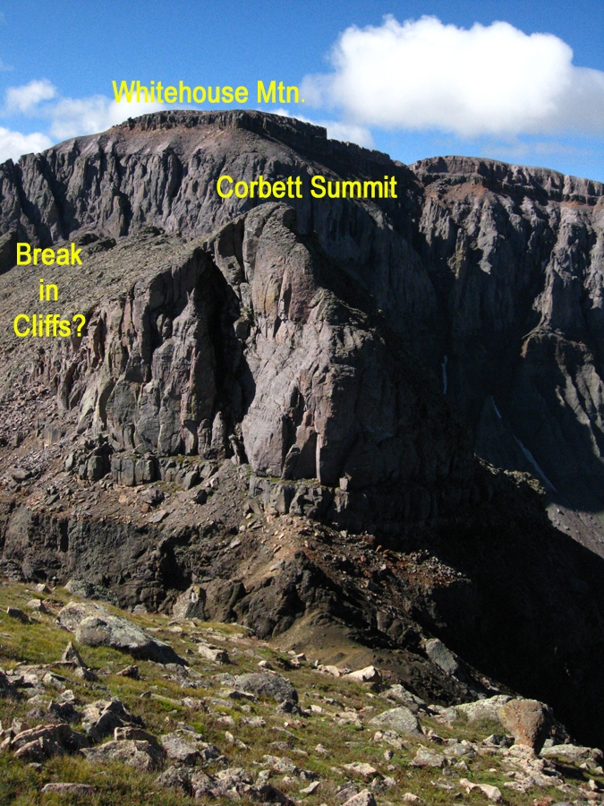
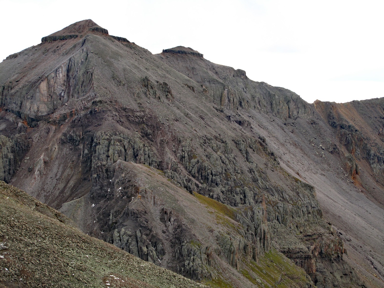
Head on into the main gully that leads to the saddle. For the next 1,000 feet, the going will be mostly on loose rock and sandy gravel. A game trail continues up through here that both elk and bighorn use to access Weehawken Basin. The last few hundred feet will be quite loose but not too difficult with the aid of the game trail. From the saddle, head up another minor couloir that leads upward to the east (left). The rock-filled and loose gully provides a break in the cliffs that surround Whitehouse. After about 200 feet of ascending, the couloir will play out. Continue ascending on small, loose rock until you break out onto the flat, summit area. Stroll the remaining 3/4 mile over to the true, eastern summit. The broad, flat summit expanse is large enough to host a football game. On either side, there are amazing views of the surrounding, rugged mountains.
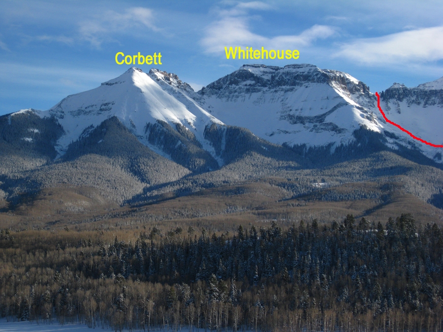
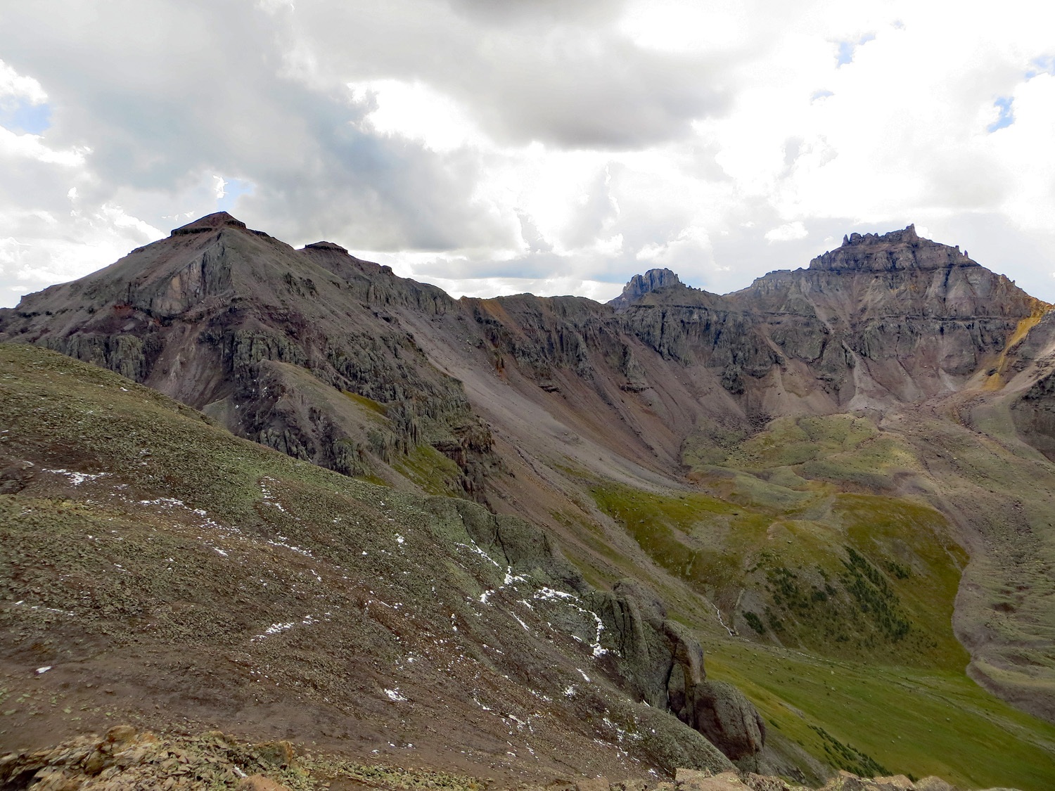
For your return, we suggest going back as you came. If doing Ridgway as well, hike back down to the Whitehouse/Ridgway saddle to begin that ascent. Also, it may be possible to hike over to Corbett, but there will be a significant drop off the summit of Whitehouse to negotiate. Sorry - we have no beta on attempting that traverse, but a few photos may help.
Click thumbnail to view full-size photo + captionRoute Description
Year Climbed: 1998Mount Ridgway is sequenced with Whitehouse Mountain. Use the route description for Whitehouse provided in the link that shows Whitehouse as an "approach." If you have climbed Whitehouse first, you will need to traverse the elongated summit back to the east and SE and descend back to the Whitehouse-Ridgway saddle. From the saddle, head right (west) along the ridge and angle up past the first cliff obstacle, then turn left and contour around the south side of the 13,150 ft. sub peak. Contour to another saddle on the west side of the sub peak. Follow the remaining rocky ridge to the summit of Ridgway. Negotiate one other minor cliff band by following a ramp up through it. From this summit, you'll have astounding views of Teakettle, Potosi, Cirque and Sneffels. They are amazingly rugged from this summit perspective. Return as you came. Hopefully on the route you bushwhacked through coming from Ridgway Hut, you left a marker of some kind to help you find your way back out by the avalanche chutes.
Additional BETA
Links to other information, routes & trip reports for this peak that may be helpful. -