#606 / 13,054' "Pyramid Mountain" Previously UN 13054
Peak Summary
With a backpack trip up and over Hermit Pass, UN13,054 (Pyramid Mountain) can be climbed from Rito Alto Lake as a single day side-trip either from the lake or from a higher camp at the trail junction described in the approach. The backpack distance will depend on the 4WD and clearance capabilities of your vehicle. Stock 4WD vehicles should be able to make it most of the way up the pass, but the road has become relentlessly rocky. The route is a stiff Class 2 that takes you by the beautiful and isolated San Isabel Lake.
"Pyramid Mountain" North Ridge Route
-
-
Hermit Pass Road TH
From the Town of Westcliffe and the intersection of Highways 69 and 96, drive south on 69 a few blocks (about .3 mile) and turn west onto Hermit Road (CR160). Drive 6 miles to an intersection where you should stay left. From this point, it's about 9 miles to the summit of Hermit Pass if you can make it. The road quickly becomes a rough 2WD for the next 1.25 miles and then degrades even more to 4WD, high clearance advisable, if not required. The higher you go on this road, the rockier it becomes with a section or two near and above tree line that crosses through talus slopes of rubble. For our suggested climb of Spread Eagle and Peak of the Clouds, park at the coordinates provided which will be a wider spot in the road at about 11,970 ft. elevation and directly below a saddle to the north that lies between Pt. 12818 and Pt. 12,671. There will be a few remaining trees here. Additional parking can be found just a little farther at the tight turn at 12,060 overlooking Horseshoe Lake. The highest we have ever made it is another saddle at 12,620 ft., just west of Pt. 12,818 and about .6 mile east of the pass.
A little history here: In November of 1989, we drove this road to climb Rito Alto and found the road to be in surprisingly good shape. We breezed right up it in a Jeep Cherokee Sport. We returned in 1996 to find that it had degraded some, but still managed to drive it with no problems in another Jeep Cherokee Sport. Our next visit to here was not until 2009 - 13 years later. In that time, the road had degraded extensively. It had become a very slow seven miles of driving on what seemed like endless rock of varying sizes. That same trip, we also drove the South Colony Lake Road all the way to its end. Between that road and the Hermit Pass road, we had to replace the complete set of shocks on our Toyota T-100! Those two roads had wiped them out. Moral of this story - drive this road at your own risk. It grants access to a large number of 13ers, but you'll have to decide if the potential price is worth it.
Camping
Once the Hermit Pass Road gets onto national forest land, there are several primitive, campsite locations all along the drive up, especially at the lower elevations. The nearest designated campground with facilities is the Alvarado CG a little further to the south out of Westcliffe. On weekends, because of close proximity to the Front Range, competition for campsites makes it more difficult to find an open spot.
Campsite Locations
Alvarado Campground › N 38° 04' 49.37", W 105° 33' 45.75"9,000 ft. elevation
-
From Hermit Pass Road TH via Rito Alto Lake
Here is a very short and easy backpack approach that can net five or six 13er summits in three days (or two for strong parties) and also has the advantage of offering a beautiful campsite in a prime wilderness setting. The mileage we offer and elevation gain ( or loss in this case) is measured from the summit of Hermit Pass. Many vehicles will not be able to make it all the way to the pass. Whatever your mileage and elevation gain are to the pass should be added to our figures to obtain a total mileage and elevation gain/loss.
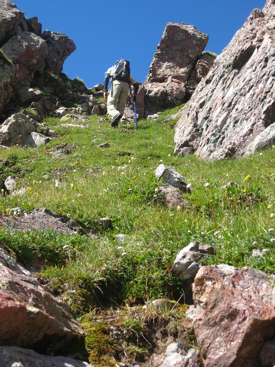
From the summit of Hermit Pass, the driveable road ends, but the original road still remains, somewhat covered now in grass, flowers, etc. It takes a downward, contouring route to the west and at 12,700 ft., switchbacks three times and then reverses direction, heading east for about .35 mile where it begins to give out. On the San Isabel National Forest Map this is Trail #747. A pack trail continues on down and forks at 11,880 ft. At that fork, continue straight west to reach Rito Alto Lake. The left fork gains an unnamed pass and then drops over into San Isabel Creek. This is how you can access UN13,054 on Trail #747. Back up on the road, at the third switchback at 12,560 ft., you can depart the roadbed and head straight down a broad ridge and slope aiming for the trail junction at 11,880 ft. By descending this way, you'll be crossing almost all tundra terrain until you reach the trail junction. As you approach that junction, low evergreens and some willows will begin to appear. At about the same elevation as the trail junction, if you walk north some, there are some benches amid the low conifers that offer some nice campsites.
From the trail junction, for Rito Alto Lake, continue down the trail (now trail #745) losing more elevation. Shortly, the trail does some brief switchbacking, then descends more to another section of switchbacks between 11,600 and 11,400 ft. where you'll enjoy a great view looking down on Rito Alto Lake and also seeing an impressive headwall cliff to the left. The trail goes along the west side of the lake and there is at least one very nice campsite on the left side of the trail by following a short spur trail up an embankment. Expect to see horse-packing groups passing through here from time to time.
Camping
The best camp location is the one mentioned above at Rito Alto Lake. As the trail drops to the lake and heads around the west side of the lake, it passes through an open area with willows and crosses a couple of small streams. It then enters open conifer forest and comes to another stream crossing. This stream will be coming more from the NW. The suggested campsite will be a little before that stream crossing. It will be on the left and up a small slope. The nice, level campsite has room for a couple tents. The nearby stream provides a good water source.
For climbing UN13,054, we suggest establishing a campsite on the benches just north of the trail junction. We found evidence of previous use here. Some rock outcrops help create the benches which provide smaller, level areas where you can pitch a tent. Good water is still close by. Deer and elk abound in the basin above that you packed down through, but watch out for aggressive marmots. Hang your food if you can find a place to do so.
Open This Approach in a New Window
Click thumbnail to view full-size photo + captionRoute Description
Year Climbed: 2009The route description for UN 13,054 (Pyramid Mountain) begins at the trail intersection east and above Rito Alto Lake where trails #747 and 745 meet. Mileage and elevation gain are measured from that point. If beginning this hike from Rito Alto Lake, add an additional .7 mile one way and 340 feet of elevation gain.
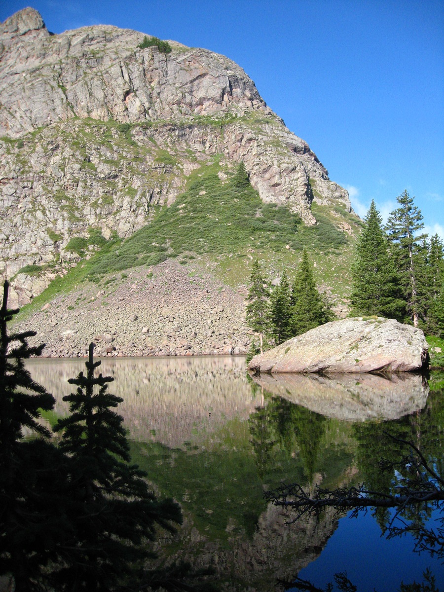
From the trail intersection mentioned in the approach, head SE following trail to a pass at 12,220 ft. This is a well-used trail by pack-horses and is steep and rugged toward the crest of the pass. On the other side, it drops steeply as well, especially as it heads into a section in the trees. The trail then crosses San Isabel creek through willows. It could be easy to lose here, but if you watch carefully, a couple of specifically placed cairns mark the trail on the other side of the creek and point the way up to San Isabel Lake. If you will make sure you identify the trail after crossing the creek, there will be no real difficulty following it except for one brief section. It will lead all the way to the lake where it ends at some potentially nice campsites.
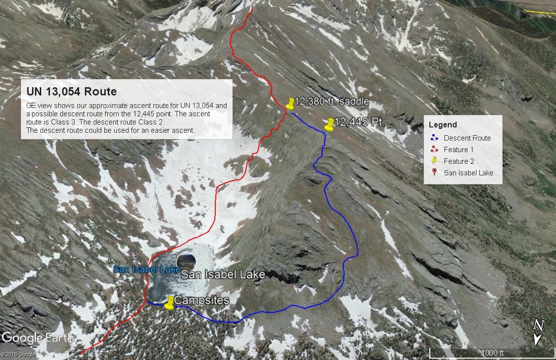
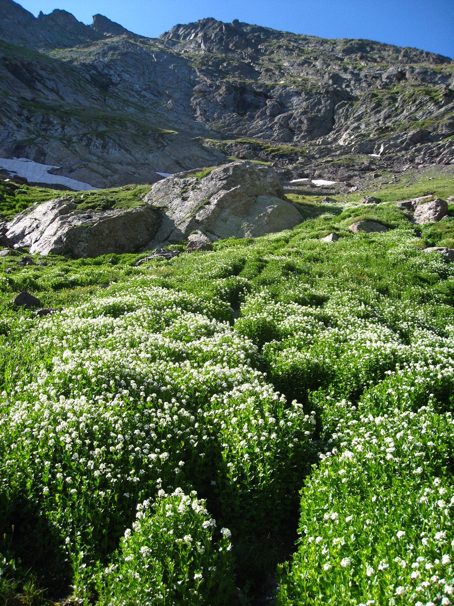
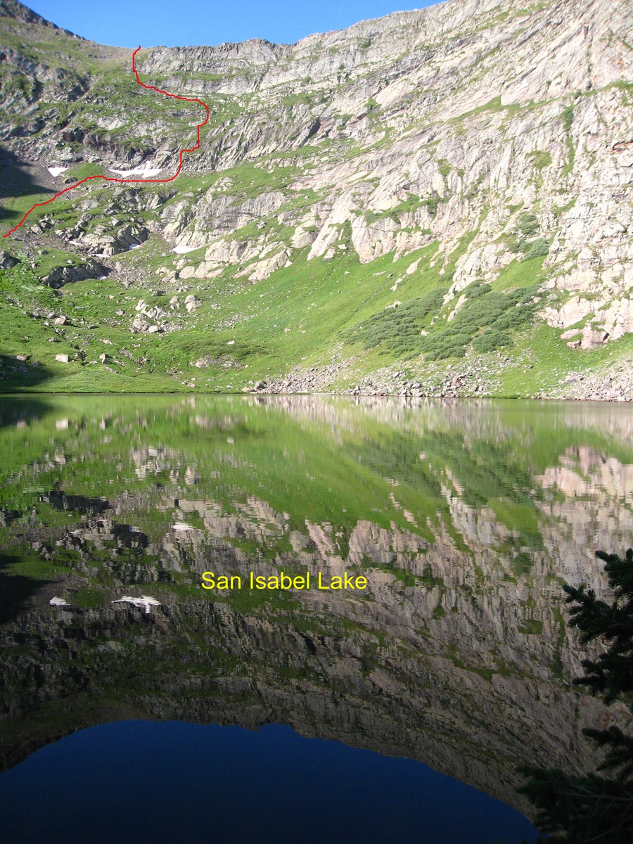
This beautiful little San Isabel Lake is situated in a basin, wrapped around by high ridges with steep walls of rock and some tundra. When we arrived here at 8:40 AM, the lake was calm and offered a beautiful reflection. On the south end of the lake, there is a lush and tall growth of a deep green plants that are topped by pure, white flower clusters. From the lake, there are at least four options for climbing the peak which actually lay over a mile distant behind the encircling ridges of this basin. Two of the options would have you swing east up the basin and gain the upper portions below the actual ridgeline and then contour back west to gain the main ridge that leads south to the summit. Another option is to ascend SSW from the lake to a saddle at 12,380 ft. A fourth option is to contour west around the prominent ridge buttress, then turn south and gain the top of the buttress and intersect the aforementioned saddle. We chose the third option, which had the advantage of being the most direct and which did not seem all that bad, even though we knew it would be steep.
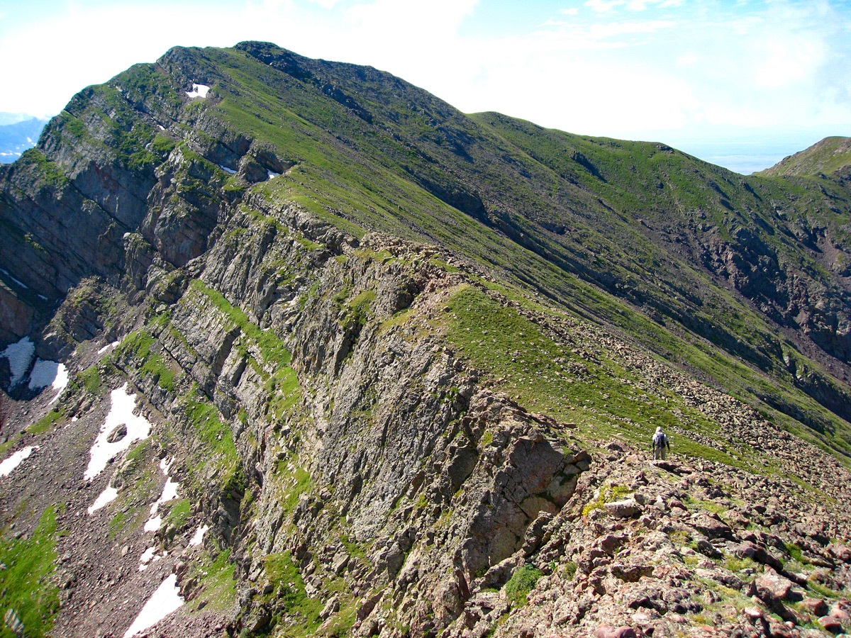
Walk up along the east side of the lake and continue south, heading into the lush flowering plants and trying to follow alongside shallow little rivulets, but staying out of the water. Avoiding the running water for us was of little help though because the plants were soaked from previous rains and morning dew. They quickly drenched our boots. As we headed up through all the plants, we began to turn SW and after about 400 feet of gain, came to the real problem of the day. Escaping the tall plants, we found ourselves on tundra slopes with grass, interspersed with rocks and boulders. We began hiking up much steeper terrain heading for the saddle more than another 400 feet up. At first, it was not too difficult to find tundra benches that wove a path in between rocky outcrops. But the higher we went, the steeper it became, and the more narrow the benches. At times, it was almost like rock climbing on tundra. There were places where even though our footing was fairly secure on the tundra, you felt a sense of exposure and continued upward progress seemed to require 3rd class scrambling. The easier sections below had lured us onto more difficult paths. We tried leaving a few cairns behind in case we came back this way, but we found this ascent route so intimidating, it was not difficult, later in the day to choose another route down.
Farther up, the slope angle finally lessens some and we found ourselves scrambling on more small rock and less tundra. Finally, we arrived at the saddle where we saw evidence of elk, but actually spotted none. From this saddle, the remainder of the route is much easier, but not fast as you walk over mostly tundra slopes with the embedded rocks so frequent to this entire range. There were at times, rock outcrops to deal with and talus areas of moderate boulders. The remainder of the route first leads upward to the SE to gain the highest point of the ridge surrounding the lake. Once on the upper ridge, turn south to follow it over the 12,957 marked summit and continue south to UN 13,054, passing another false summit along the way. Most of the ridge is low tundra with embedded rocks.
UN 13,054 "Pyramid Mountain," is the high point of a subset group of peaks on the west side of the main spine of the Sangre de Cristo range. The “Groundhog Basin” below on the east side looks remote and inviting. You can gaze partially down into it through a rugged cleft on the NE face of this peak. From our perspective, you could look either south or north along the range and see the highly tilted, conglomerate, layered rocks in clear relief that so characterize this entire area. If there is any threat of weather, it is best however to not linger too long on this wonderfully isolated summit because the trek back leaves you on exposed ridge for quite a distance.
For the descent, return to the saddle above the lake at 12,380 ft. (As we looked down upon the saddle, we watched a small group of elk cross up to the saddle from the east side, then when they spotted us, they moved off to the north end of the ridge and disappeared from site.) Since elk do not climb cliffs, their descent to the north aroused our interest, so we hiked to the top of the 12,445 marker instead of returning back down the steep slope we had come up from the lake on. From the 12,445 point we headed down the north slope. A photo we had from a friend of this north slope indicated a tundra covered slope that swept down the north side several hundred feet and then a more horizontal tundra bench that would lead us back over to the lake with some willows as you approach the lake. We followed this route as best we could. From the 12,445 point, we headed down following the natural slope of the strata for a while before cutting back east on a minor tundra bench and then hitting the wider tundra slope in the photo. There was a fairly deep gully that guided us down for some distance, but there’s any number of ways you could make your way down this mountainside. You just have to be careful to avoid the rockier outcrops and sloping cliffs. As the contours tightened up, we decided that we needed to begin contouring back to the east, hoping to come out in the vicinity of the lake. We had to cross some more minor gullies and traverse both rock and tundra, but to our relief, we did come out a little above the lake and worked our way down to the NW corner of the lake where the terrain dropped us into a swag a little below the lake. We hiked up out of that and got back to the lake level, where we located the trail back down to San Isabel Creek. Follow the trail back up over the 12,220 foot pass, then back down to the trail intersection or Rito Alto Lake.
Additional BETA
Links to other information, routes & trip reports for this peak that may be helpful. -