LoJ: #505 (Pre-LiDAR #506) / 13,171' UN 13171 Formerly UN 13169
Range ›
San Juan Range
Quadrangle ›
Rio Grande Pyramid
Summit Location ›
 N 37° 39' 32.43", W 107° 29' 21.31"
(Not Field Checked)
N 37° 39' 32.43", W 107° 29' 21.31"
(Not Field Checked)
Neighboring Peaks ›
UN 13232 [Formerly UN 13230]
Mount Nebo
UN 13121 [Formerly UN 13110]
Peak Summary
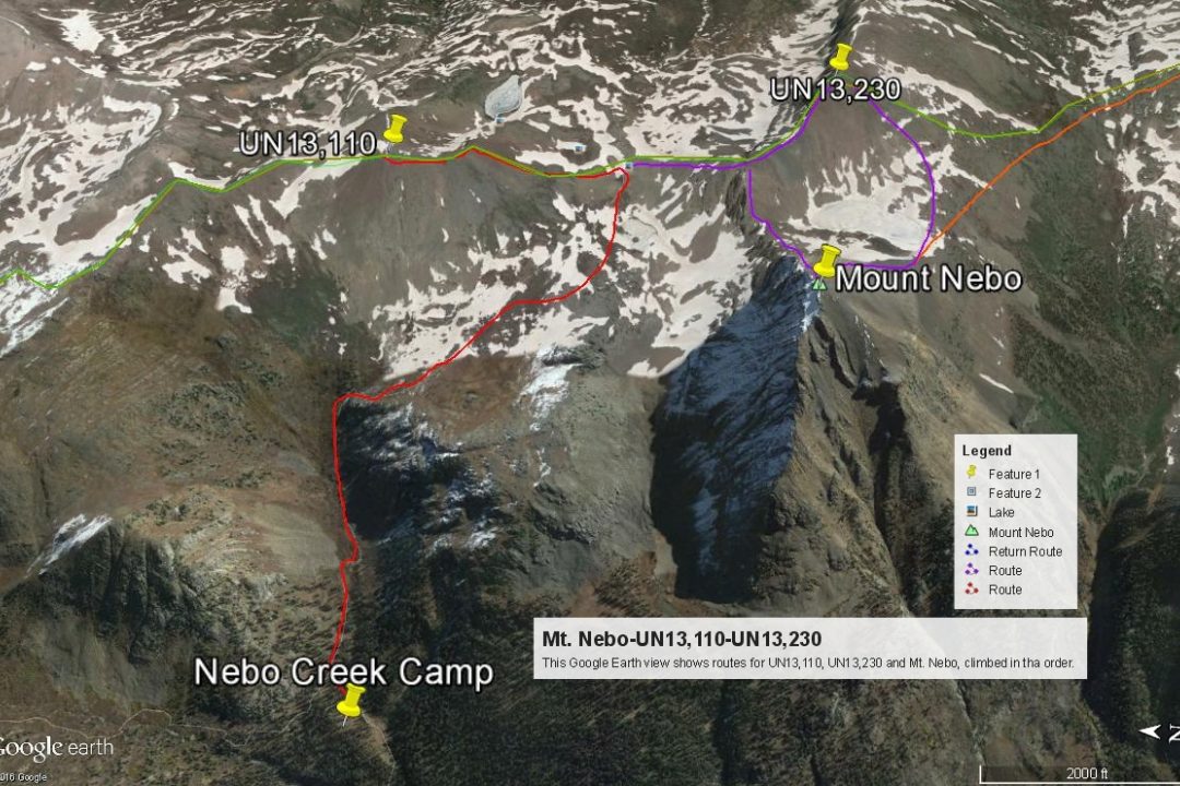
UN13,171 is a Class 2 hike that utilizes a segment of the Continental Divide Trail both on the approach and the return and is located in the heart of the Weminuche Wilderness. The closest vehicle access is the Beartown/Kite Lake trailhead north of Hunchback Pass. 4WD with good clearance is required to reach this trailhead. Most climbers will want to climb other nearby 13ers located all along Vallecito and Rock Creeks, turning this into a multi-day backpack trip. Climbers may want to pair this summit with UN13,121, UN13,232 and Mt. Nebo. Lidar increased elevation of this summit by 2 feet.
UN13,171 NW Ridge Route
Class 2
RT From Bear Creek/Hunchback Pass/Kite Lake:
16 mi / 6,735'
RT From
Nebo Creek
with
"Formerly UN 13110"+"Formerly UN 13230"+Mount Nebo:
10.5 mi / 4,835'
From Mount Nebo:
1.75 mi / 1,000' (One-Way)
-
-
Bear Creek/Hunchback Pass/Kite Lake TH
WARNING: This trail head approach REQUIRES 4WD with good ground clearance. The drive as described below from Silverton may take up to 2.5 hours.
From the Town of Silverton, and where the main road splits at the NE end of town, drive 4.2 miles NE up along the Animas River on blue-signed County Road 2 to Howardsville. Turn right onto FR589 up Cunningham Gulch and stay right at the turn for the "Old Mine Tour" (4.4 miles) but do take the left fork toward Stony Pass (FR737) at 5.9miles. Once on the Stony Pass Road, expect 4W conditions. The road climbs steeply to the pass. Abundant wildflowers as you approach the pass may delay you. Once across the pass, the road becomes FR520 and eventually leads to Rio Grande Reservoir, but you will not drive that far. The road eventually descends down the valley to a low water crossing of Pole Creek. There are several primitive campsites on both sides of the Pole Creek crossing. Watch out for the steep embankment climb out on the east side if the road is wet from rains. You could easily slip off the edge. After the crossing, continue south for under a mile to another fork where you'll turn right (west). Another long, low water crossing is found here across the Rio Grande River. This crossing is usually more shallow than the Pole Creek, but the closer you are to runoff season, the more difficult these crossings will be.
It is also possible to come into this area from either Creede or Lake City over Slumgullion and Spring Pass to Rio Grande Reservoir. From state highway 149 either about 20.5 miles from Creede or 32 miles from Lake City, turn west onto FS520 and drive all the way to the reservoir on the well-signed, graded dirt road. Passenger cars can make it all the way to the "Lost Trail Campground" at the far west end of the reservoir. Beyond that point, FR520 continues west and crosses some rugged sections before connecting with the other section of FR520 coming down from Stony Pass and the low-water crossing of the Rio Grande. We have never driven in all the way on this section and from those we know who have, they have complained about one particularly difficult stretch.
From the Rio Grande crossing, continue up what is now, the Beartown Road for a slow 4 miles (mainly because of potholes) to the former location of Beartown. (There's really nothing left to see there, but just before the road crosses Bear Creek, beyond the old townsite, there is some good camping. The road goes all the way to Kite Lake at about 12,100 ft., but the Hunchback Pass trailhead is about 1/2 mile below the lake. There's a trail sign there and some very limited parking is available. Road Notes as of 2018: About half the distance toward Beartown, the road crosses an unnamed creek and at that spot, there are some difficult mud/potholes that have really been dug out. Longer bed vehicles may have some difficulty getting through. Take it slow. Closer to Beartown, the road passes through a fence line. At that point, the road conditions will begin to deteriorate and become more rocky as it begins to gain some elevation.
As the road begins climbing more steeply toward Kite Lake and the Hunchback trailhead, after crossing Bear Creek, it becomes quite a bit more rocky in that stretch as well. For a long section, the road is deeply entrenched in the middle because of runoff and the trench tends to fill with loose rocks. If you have driven in here to do the Ute Ridge group of summits, camp in the vicinity of where the road crosses Bear Creek just past the old Beartown site. See coordinates below. From that creek crossing, it's not quite .3 mile to the trailhead for Ute Ridge, which is a jeep track that turns off to the left and drops down to cross another lesser fork of Bear Creek. Park somewhere along this track if heading for Ute Ridge. On the Caltopo map, this trail is called the "Bear Town Trail" and designated FR869. On trails Illustrated Map #140, it does not appear to have a designation. Coordinates for this road & trailhead are: N 37° 42' 54.53" W 107° 30' 35.00". You can find a good camp spot here as well. You can also find some additional camp spots within a few hundred yards of the Hunchback Pass trailhead. One of those spots goes off to the south to an old mining area.
Camping
You can find some very limited camping spots in the immediate vicinity of the Hunchback trailhead. There's one particularly good spot back down the road a fairly short distance on the south side. There's also some good camping back toward the Beartown site. See coordinates provided.
Campsite Locations
Beartown Campsite › N 37° 43' 05.02", W 107° 30' 35.47"
-
From Bear Creek/Hunchback Pass/Kite Lake TH via Nebo Creek & Mount Nebo:
-
UN13,121 South Ridge Class 2 / 2.0 mi / 1,660’ One-Way
Open This Route in a New WindowThe route for this summit begins from our suggested campsite near the junction of the Vallecito trail #529 and the Continental Divide Trail #813, south of Hunchback Pass. UN13,121 is the first summit in a four-summit day. It is sequenced with UN13,232; Mt. Nebo and UN13,171.
From that campsite and the nearby trail junction, walk east up along Nebo Creek on the Continental Divide Trail. Just past the last trees, some avalanche debris and snow in 2005 obscured the trail for a while. The trail heads uphill to the east for a while above the trees and through the willow-clogged valley with UN13,121 in full view, then swings SE into a great, tundra basin, climbing on a few switchbacks. There's a scenic tarn below the pass on the west side. From that tarn, you may want to begin veering north toward the south ridge of UN13,121 instead of going all the way to the pass on the trail. In July, there will be abundant wildflowers and some especially nice columbine nestled in between lichen-covered rocks heading up this way.
Once on the south ridge of the peak walk north toward the summit. The journey to this first summit will be over mostly tundra with some broken rock (rubble) interspersed. Enjoy the fairly easy hiking.
-
UN13,232 NW Ridge Class 2 / 1.1 mi / 775’ One-Way
Open This Route in a New WindowUN13,232 is sequenced with UN13,121 to the north. Mileage and elevation gain estimates are measured from the UN13,121 summit. From UN13,121 walk south back down the ridge to the connecting saddle between it and UN13,232. You will cross the Continental Divide Trail at the saddle. Begin ascending first, a NNE/SSW running ridge of UN13,232 on mostly broken rock. Earlier in the season some snow along the ridge may help avoid some of the rock. Nearing the top of this section of ridge, you may want to veer over into a steep couloir to reach the flatter section of the NW ridge. This flatter section offers a reprieve from the rubble, at least briefly. Proceed SE along the ridge crest for the most part, but always on the south side. As the ridge steepens, on the north side there will be precipitous cliffs, while the south side will be mainly rock rubble that will become increasingly large as you more slowly approach the summit. Time from UN13,121 should be an hour or less. From this summit, decide if you want to continue to Mt. Nebo and choose the best the course to do so. Since Nebo is the highest 13er in this group, it would make little sense to leave it hanging.
-
Mt. Nebo SE Ridge Class 2 / 0.9 mi / 725’ One-Way
Open This Route in a New WindowMt. Nebo is sequenced with UN13,110 and UN13,230, in that order. Elevation gain and mileage are measured from the summit of UN13,230. There are two routes you can take from UN13,230 over to Nebo. One would be to hike back down the NW ridge of UN13,230 back to the flatter section of ridge, then follow the connecting ridge west over to Nebo. At first, you may see some cliffs that appear to harbor some problems for this traverse. It turns out they do not offer any serious obstruction. Once down to the saddle, it's a rocky, rubbly walk to the summit. The mileage this way is shorter, about.75 mile and the elevation gain is less, coming in at about 500 feet.
Our route took us down off the summit of UN13,230 by walking south and SW off the summit, on mostly all tedious, medium-sized rubble. Swing west as you descend to the outlet of the unnamed lake that lies between Mt. Nebo and UN13,230. Cross the outlet and then begin re-ascending the broad, SE ridge of Nebo. Nice tundra initially will give way to small chiprock from something that appears shale-like. This will making footing a little loose and you may be slipping back on some steps. Time from UN13,230 will be about 1 hour.
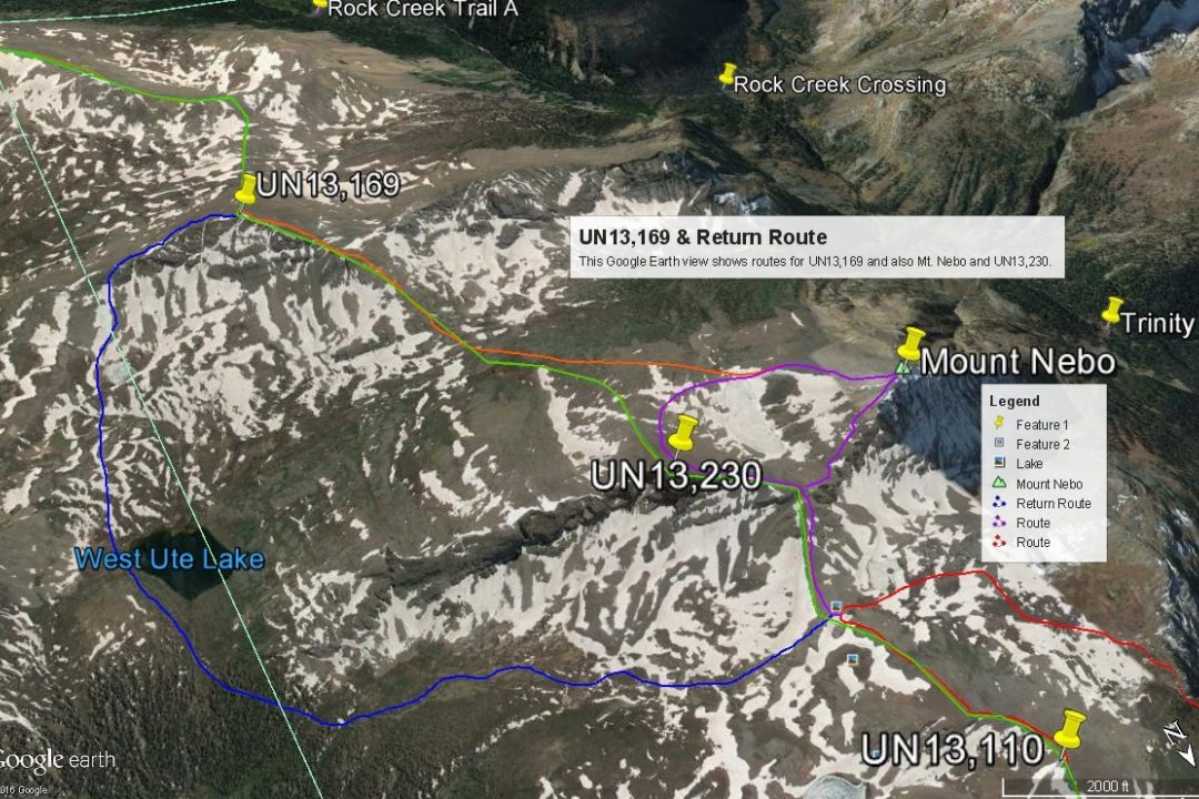
Mt. Nebo offers an striking view of both the Vallecito drainage and the Rock Creek drainage as well and all the peaks surrounding them. You can see north all the way to Hunchback Pass or virtually all the way down to Vallecito Reservoir. You can see almost all the Needle Mountains and Grenadier summits. From this summit, you can call it a day and head back to camp and get back at a reasonable hour. But if you wish to "clean out" the 13ers in this locale, then one more lies to the south, which we added to our day - UN13,169.
-
Route Description
Year Climbed: 2005UN13,171 is the fourth peak in a sequence that begins with UN13,121, then goes to UN13,232 and Mt. Nebo. Mileage and elevation gain estimates are measured from the summit of Mt. Nebo. Because of a starting point at the suggested campsite near the Vallecito/Continental Divide trail intersection, the one-day mileage for all four peaks becomes rather lengthy and the total elevation gain substantial.
From the summit of Mt. Nebo, head down the broad SE ridge, previously described on the Mt. Nebo page. Cross the outlet of the unnamed lake and head SE across mostly tundra/grass terrain toward a broad saddle between UN13,171 and UN13,232, gradually losing some elevation. Below the lake, it will be somewhat rocky at first. There will also be scattered willows. At the saddle, head SE, gaining 600 feet in elevation that will bring you to a flatter, plateau section of the ridge and a slight change of direction that's more easterly. This initial 600 feet will utilize tundra benches, larger boulders and slabs of rock and becomes more rubbly higher up. From the plateau at 12,800 feet, stumble your way across mostly medium rubble to the mostly rocky summit.
From the summit of UN13,171 you'll enjoy an impressive view of the Rock Creek drainage and the many peaks in that area. You can also see much of the vast tundra and willow-covered area to the east and south that forms the highlands of the Flint Lakes area and the head of Middle Ute Creek. This is all prime elk habitat area and possibly moose.
With a before 7:00 AM start from our suggested base camp, it took us a little over seven hours to reach this last of four summits and begin the trek back to camp. That distance covers another 4.75 miles and you have to regain at least 660 feet in elevation. The good news is, you can do much of this return utilizing the Continental Divide trail. To do so, head down the east ridge of the peak among large rocks with tundra interspersed. At about the 12,720 foot level, to short cut things, you can turn down what may be a snow-covered slope to the north that offers a quick glissade down in the direction of two unnamed, small ponds. You can pick up the CD trail at the more northerly of the two ponds and follow it through abundant willow terrain to West Ute Lake. From the lake, keep following the trail as it winds through more willows, begins to turn NW and starts gaining elevation back to the pass between UN13,121 and UN13,232. Frustrated with all the willows, we abandoned the trail and tried to walk up the valley closers to the cliffs of UN13,232, at the foot of the huge rock glaciers. This allowed some tundra walking, but it was also boggy in places. Once you gain the pass, just follow the CD trail back to your starting point.
Additional BETA
Links to other information, routes & trip reports for this peak that may be helpful. -


Warning!
Climbing peaks can be dangerous! By using this site and the information contained herein, you're agreeing to use common sense, good judgement, and to not hold us liable nor sue us for any reason. Legal Notice & Terms of Use.