Trailhead › Castle Ck./Castle Pk.
Directions
From the busy traffic circle on the west side of Aspen on SH82 and just east of the airport business center, take the exit for the Castle Creek Road (CR15) and drive a long 11 miles to the townsite of Ashcroft. Measure from the Toklat Lodge and drive another 2.0 miles south to an intersection at these coordinates: N 39° 01' 45.17" W 106° 48' 28.26". (Or from the Pine Creek Cookhouse and the Ashcroft Ski Touring Center located on the west side of the highway it's another .6 mile). There is a kiosk sign here and parking for a number of vehicles on the west side of the road. If in a passenger vehicle with lower clearance, you may want to park here, but some crossover types may still proceed to make a right turn and head SW on FR 102, aka: the Pearl Pass Road. (ON GE this is labelled CR 15D). At the aforementioned intersection, there is a paved road that continues due south and goes all the way to a mine/quarry on the northern flank of Star Peak. That road does not show on the unrevised USGS quad and other maps as well like FSTopo 2016. You do not want that road anyhow for the Castle Creek TH.
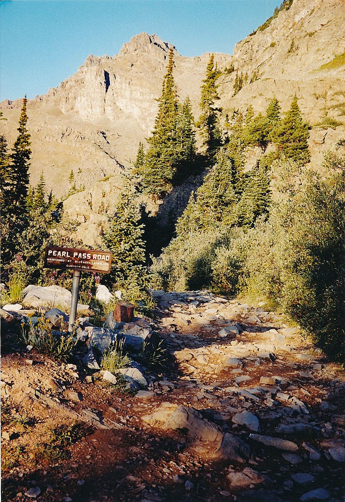
Once you've turned onto FR 102, drive SW for about 1.4 mile to a low water crossing of Castle Creek. In early runoff season, fording here could be problematic. Roach points out that about a half mile in on this road, it steepens and becomes "dramatically rougher." His more recent report validates what we also found in 1993. There is also a footbridge for hikers. It's been there at least since 1980. There are some at-large campsites along the way. If you have a higher clearance vehicle and don't mind the rougher road, continue to the stream crossing. This is what we are identifying as the trailhead. See coordinates above. On the other side of the creek and a little farther along are more campsites. Beyond this point, we recommend 4WD with good clearance if you want to drive farther. With an adequate 4WD, the road may be driven all the way up into the basin north of Castle Peak at 12,775 ft. In prior years, we have made it up here in both a Jeep Cherokee and a Toyota T-100. It is rough and slow going and downed trees that have not been cleared off may stymie progress. If you make it as far as the Pearl Pass junction, the road to Pearl Pass takes off to the left and begins a steep climb through the trees. The road is very rocky and is a challenge to drive. (See photo). Stream runoff on the road has washed away most dirt leaving only rocks to drive on. Once out of the trees, the difficulty moderates some for a while. There is room at the intersection for Pearl Pass and the Castle/Conundrum Basin for about two or three vehicles to park.
If continuing to drive north into the basin north of Castle, the last time we were on this road (2003), the roughest section came shortly after the Pearl Pass turnoff. It was not too difficult, but the remaining drive will be slow because the road remains rocky and rough. We were in a Toyota T-100 at the time.
Camping
There are no National Forest campgrounds along the road to Ashcroft. As mentioned before, there are a few at-large primitive sites along FR102 both before & after crossing Castle Creek. There may also be usable sites back near Ashcroft and around the turnoff for the Taylor Pass road. Also, on the road up to the Cathdral Lake TH, there are a couple of primitive sites. There is a lot of private property all along CR15. Be careful where you try to camp. As with most areas in the summer, weekend use is heavy and unoccupied camp spots difficult to locate.