LoJ: #512 (Pre-LiDAR #508) / 13,164' Amherst Mountain
Peak Summary
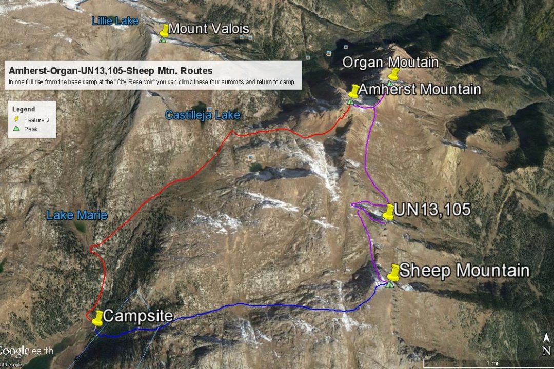
Amherst Mountain is a Class 3 or Class 4 ascent (depending on route taken) which we have sequenced with three other low 13ers for a moderately long day hike from a base camp at the Durango Reservoir #1. Our suggested trip includes a backpack trip up the Endlich Mesa trail out of Durango. A vehicle with good ground clearance is required to access the trailhead, though rugged 4WD is not necessary. This suggested backpack/climbing trip can net six ranked 13ers over a maximum four day period. Lidar dropped the elevation on this summit by a foot.
Amherst Mtn. SW Face Route
-
-
Endlich Mesa Trailhead
This trailhead description will begin from downtown Durango. If coming from the north of town on US550, drive south until 550 (aka: Main Street) crosses the Animas River. Less than 2 blocks after that crossing, turn east (left) onto 15th St. In a few blocks, this road turns NE and becomes Florida Rd., which in turn is CR240. Follow this paved road through mostly residential areas as it gains elevation for just under 12 miles to an intersection. Turn left onto CR243 and drive north to Lemon Reservoir. It's just over 4 miles to the reservoir where the road turns to graded gravel. Now drive 5.4 miles along the east shore of the reservoir and past the north end of it to a turnoff for the Florida Campground. Do not turn, but continue straight onto what will become FR597, aka: "East Florida Road" on the Trails Illustrated map. The road soon degenerates and heads generally NE, climbing up the mountainside on numerous switchbacks. The long and winding road continues from the Florida Campground turnoff for nearly 10 miles to the trailhead. There will be several at-large camping opportunities along the way as well as in the vicinity of the trailhead. The road is basically "single-lane," and though you really don't need 4WD, extra clearance is of help because the road is arduously rocky. You can never go very fast unless you want to rattle your vehicle to death. It took us about an hour and a half from Durango. Along FR597, there are numerous meadows with abundant yellow wildflowers. There were some potholes toward the end, but nothing challenging. We drove this road in 2006. Be aware that during our 2006 visit, we saw clear indications that a large group of domestic sheep are moved up this road and trail for summer grazing. You may encounter large trucks as a result.
Update 2020: We received this update from a site user. As with many Forest Service roads, apparently budget constraints restrict the amount of grading and other work that can be done on FS roads so most roads tend to fall into neglect and worsen in condition over the years. This road has apparently become one of those casualties. We were advised that the road has become even rockier, requiring slower driving and more time from Durango. The site user suggests that it may now take a minimum of two hours to 2.5 hours to make this drive. He also strongly advises that AWD or 4WD vehicles should be used with higher clearance. He did report seeing a RAV4 at the trailhead with apparent undercarriage damage from the drive. Please take this information into consideration when planning your trip.
-
From Endlich Mesa TH via City Reservoir #1
From the trailhead parking area, the trail (#534) heads NE on a switchback path of an old, highly rutted roadbed toward Endlich Mesa. We found a trail that ran somewhat parallel but which avoided the half dozen switchbacks by taking a more direct route upward. A steady but fairly gentle climb for a mile brings you to treeline. When we hiked this, the trail was covered with sheep prints and numerous smelly deposits. Once on the open ridge, there will be several miles (about 5) of open, tundra hiking with distant, spectacular vistas in most every direction except east. Take the opportunity at times to walk off the trail to the east and gaze down into the basins where we spotted elk on more than one occasion. The trail remains easy to walk and just as easy to follow, cresting out at about 12,200 ft.
After about 5 miles the trail crossed a small ridge and there was a fork to the left. Take this fork that heads down to City Reservoir #1 in the City of Durango watershed. Unlike the City of Boulder watershed in the Indian Peaks, you can legally enter here and even camp without threat of prosecution. The trail drops steeply down initially for a knee-bashing descent of 1,400 vertical feet to the reservoir. Remember that when you leave this area, you may have to pack back up this section of trail. You may observe some nice wildflowers along the way. The Trails Illustrated map shows the trail branching down near the reservoir. Either fork will get you there, but the right fork, may be a little shorter if the trail is still visible. Cross the dam at the south end and walk along the west shore toward the NE and the upper end of the reservoir. There is a nice campsite at that NE end on the edge of the trees with easy access to the lake. Streams are nearby for fresh water. The largest campsite can accommodate several tents easily, while nearby are several other smaller campsites. It took us about 4.5 hours to make this backpack in.
Campsite Locations
City Reservoir #1 Camp N 37° 32' 39.18", W 107° 35' 04.52"
Open This Approach in a New Window
Route Description
Year Climbed: 2006From the proposed base camp at the NE end of City Reservoir #1, head north on the trail up to Lake Marie hiking steeply up the forested drainage. In the vicinity of where the USGS map indicates to site of "Logtown," cross the creek to the NE. In 2006, we found a rock cairn marking a place to cross the stream where it passes over some rocks. After crossing, we bushwhacked up steeply through some willows on a fairly well-defined trail that showed passage of horses recently. The trail eventually took us on the east side of the creek that drains Castilleja Lake (Durango Reservoir #4). We passed a nice campsite on the way up along this stream in the open area that the map shows NE of Logtown. In the upper reaches of the valley, the trail fades away, but hiking is easy and quick across tundra and grass. Walk on past the three small tarns south of the two larger, unnamed lakes. Just before where this valley drops off steeply to the north, contour east and work your way over into another large valley/basin that heads eastward to Amherst. This basin will also be filled with tundra and grass until you come below the SW face of Amherst. The upper end of the basin becomes mostly broken rock.
At the time we made this climb, the only beta we had was the 'Guide To the Colorado Mountains" which said to "hike" up the SW face of Amherst, then to continue over to Organ. That was certainly an understatement. The word "Hike" is not an adequate description for the rocky and steep SW face. From here, note that there are two basic ways to the summit that we will mention. Looking over to the south ridge of Amherst, you'll notice a significant notch with a reddish gully that runs up to the notch. "Furthermore" on LoJ went up that gully to the notch, rating it a 3rd class scramble, but did not proceed up the south ridge, Instead, he angled over to the Amherst/Organ saddle and climbed Organ first, then went back to the saddle and ascended Amherst by its east ridge. His account is not very clear as to how he descended Amherst, but it sounds as though he descended the south ridge back to the notch. He does not mention anything harder than 3rd class. We did not choose to go that way, but our notes observe that the notch and the south ridge would have been easier than how we went.
The route we took went directly up the SW face. We walked up a moderately steep runout slope until it steepened and we began to scramble up the main face. We headed in the general direction of a dark, almost black crack, staying to the left generally. At one point we found ourselves navigating a steep, sloping shelf covered with loose gravel. We actually used a short piece of rope here to belay each other up this shelf with one of us taking the lead ascending a short, but near vertical step to another shelf from which a belay could be offered. This was only for a few feet, but this was the crux, 4th class section. The rope was mainly used because of the loose gravel. The upper shelf really offered nothing to belay from. Once above this crux, things eased up a bit. A little further up, we found a steep ramp leading right that brought us out on the south ridge, and east flank of the peak, just below the summit for a more pleasant finish. Looking back down the south ridge to the notch mentioned earlier confirmed to us that the notch and south ridge/east flank combo would have been simpler. This is one of those cases where we do not recommend our own route.
From the summit, you'll enjoy a good view over to Organ Mountain which pairs very nicely with Amherst if time and weather allows. There's also a great view looking across Johnson Creek to McCauley and Grizzly.
Additional BETA
Links to other information, routes & trip reports for this peak that may be helpful. -