LoJ: Not Ranked / 13,526' Browns Peak
Peak Summary
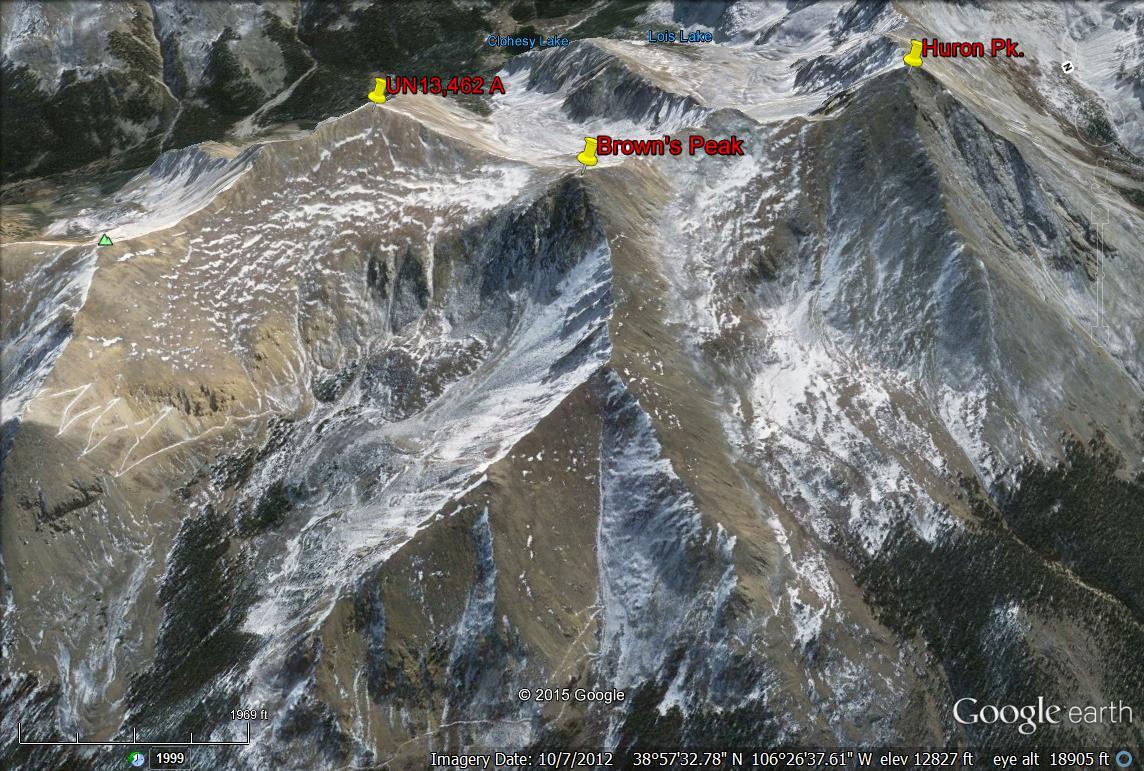
Browns Peak is an unranked summit located between UN 13,462 A and the 14er, Huron Peak. It is a Class 2 hike from Lulu Gulch and can be easily sequenced with UN 13,462 A. If starting from the bridge across Clear Creek, just south of Winfield, 4WD or higher clearance is not required, but this increases overall mileage by about 1.5. To reach the Lulu Gulch old road, a higher clearance vehicle is preferred.
Browns Peak East & South Ridges Route
-
-
Clear Creek/Winfield/Apostles TH
From Leadville, drive south a little over 19 miles on HWY 24 to the turnoff for Clear Creek Reservoir (CR390) and head west. The turn is less than 2 miles south of "Granite." From Buena Vista, drive north just under 15 miles to the same turnoff. Drive west on graded dirt road 11.7 miles to Winfield. As the road approaches Winfield, it will become a little more narrow and likely to have some potholes. Because of heavy use, this road is often washboarded badly. At Winfield, turn south and cross the creek and continue south, then SW on CR390.2B. About 100 yards after crossing the creek, passenger cars may want to park because the road greatly deteriorates beyond there. Higher clearance vehicles may continue. 4WD is not really required for the remainder of the drive to the end of the road. At a little over .7 mile after crossing Clear Creek, just south of Winfield is the turnoff for the blocked road to Lulu Gulch, UN 13,462 A and Browns Peak. From Winfield it's about 2.25 miles to the end of the road and some limited parking. This trailhead is used for both Huron Peak and routes to the Apostles.
If using this general trailhead description for access to peaks up the Lake Fork of Clear Creek (Clohesy Lake), then do not drive all the way to Winfield. Instead, you'll need to turn left at 9.8 miles in from US24 and drive down through the few cabins that comprise "Rockdale," ford Clear Creek and drive to the Clohesy Lake trailhead with a starting elevation of 10,900 ft. 4WD required for this access, otherwise, walk it and enjoy the frigid and sometimes dangerous crossing of Clear Creek.
Camping
For the access to Huron and the Apostles, best camping opportunities are along the final two miles to the trailhead from Winfield. There are several at-large spots available. Camping before Winfield can be difficult because of private property and the large number of people coming to climb Belford, Oxford and Missouri.
There are good campsites for backpackers in the vicinity of "Hamilton" along the Huron Route and the trail up toward the Apostles. There are also good campsites in the meadow just north of the rock glacier at about 11,400 feet or a little lower.
If heading up the Lake Fork toward Clohesy Lake, there is at-large camping at the trailhead which is at a large, open meadow area that's relatively flat. Coordinates are: N 38° 57' 15.48" W 106° 24' 32.64"
-
From UN 13471
Open This Route in a New WindowUse the trailhead description provided but after crossing the creek in Winfield, you only need to drive about .7 mile to where an old mining road comes in from the left (east). On our last visit to this area, that road was gated and closed, but when we first climbed this peak in 1997, we were able to drive it to about 11,600 feet in Lulu Basin and the road was in surprisingly good condition. Since the road no longer shows on the Forest Service map, it has likely been closed permanently. The USGS Winfield 1982 quad does show this road. Total mileage and elevation gain are based on the assumption the road is closed and that you'll be able to start from .7 mile SW of Winfield. Passenger cars will have trouble continuing past Winfield however. Shortly after crossing the creek there, (100 yards) there is a place to park. The next .7 mile is best completed in a higher clearance vehicle.
Begin hiking up the old mining road through forest and up multiple switchbacks for the first mile. At a point on the USGS quad with a marked elevation of 11,393 ft., make sure you follow the road that heads east and rounds the broad ridge into Lulu Basin. This old road can be followed further up the basin and it actually goes most all the way up to Middle Mountain. Depart the road on a switchback at 11,920 ft. at some of the last trees. Continue up valley on mostly tundra, then walk more steeply for about 400 feet in elevation gain to a broader, bench-like area below the saddle between UN13,462 and Brown's Peak. Walk on up to the saddle and turn left to follow the easy ridge for a pleasant stroll to the summit of UN13,462. You will enjoy a great view of Clohesy Lake far below to the SE and of Missouri Mountain further east. You should also be able to see hikers reaching the summit of Huron Peak about 1.5 miles south.
For a descent, either return as you came or head over to tag Brown's Peak, a higher but unranked summit because it does not rise the required 300 feet above the connecting saddle with Huron. From Brown's Peak, it is also possible to continue along the ridge south to Huron Peak at no more than a Class 2+ level. From Pt.13,518, the going will be rockier with some minor problems and as you approach the summit of Huron, you'll encounter the typical broken rock of the higher altitudes, but you will have the aid of the official Huron trail which you'll pick up just a little south of Pt.13,518. From the summit of Huron, you can descend on the Huron trail back down to FR390.2B and walk north back to your vehicle.
Route Description
Year Climbed: 1997We hiked Browns Peak on a day in which we first hiked UN 13,462 A, then Browns and continued on to Huron for our son's sake, who wanted to climb a 14er. The result - we traversed both the east and south ridges of Browns. We have sequenced Browns with UN 13,462 A. One-way mileage and elevation gain are measured from the summit of UN 13, 462 A. Round-trip mileage and elevation gain assume completion of the sequence, but do not include pressing on to Huron.
From UN 13,462 A, simply follow the ridge crest west toward Browns Peak. This is largely a tundra stroll though the summit is an interesting conglomeration of broken rock outcrops. The traverse over can be easily made in 20 minutes.
If trying to reach Browns from Huron Peak, walk north, at first utilizing the Huron Trail that passes through typical 14er summit, boulder rubble, then departing the trail once it leaves the ridge and begins to switchback down the west flank. Continue north along the ridge crest. You will need to either go over or contour around Pt. 13,518 which has some minor rock outcrops to navigate around. The remainder of the hike is easy Class 2 to the summit of Browns.
Additional BETA
Links to other information, routes & trip reports for this peak that may be helpful. -
