LoJ: #191 (Pre-LiDAR #195) / 13,597' Cottonwood Peak
Peak Summary
Cottonwood Peak in the Sangre de Cristo Range is an easy Class 2 walk-up, but with a fairly difficult approach via the forest service road to Rainbow Lake, and beyond to the Silver Lake trailhead. The challenge of this summit is in the drive to reach the TH. A high-clearance, 4WD is required. If you do not have one, you'll be hiking many more miles, from either side of the range. Without 4WD, climbers may want to consider hiking in on the Hot Springs Trail that begins on the west side of the range at the Garner Creek Hot Springs trailhead and heading up Hot Springs Canyon, a route which we have no fist-hand experience with. Pre-Lidar elevation was 13,588.
Cottonwood Peak East Face Route
-
-
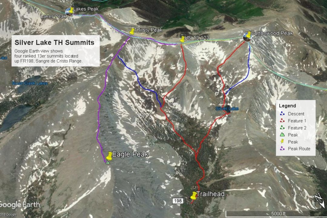
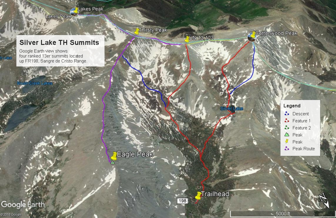
Silver Lake - Cloverdale Basin TH
From the town of Westcliffe, drive 11 miles north on SH 69 to just south of a "township" called "Hillside." At a substantial curve in the highway, turn west onto CR 198. This is easy to miss. The road first heads SW, then turns west. Follow this road for three miles to the Lake Creek Campground and the turnoff for a Lutheran camp close by. The Lake Creek Road # 198, is dirt and in good condition for about the first 3 miles to the camps. Just after the campground and turnoff for the Lutheran camp, the road becomes steeper and rocky and is only passable with a high-clearance 4-wheel drive vehicle. This road passes by Balman Reservoir and Rainbow Lake. Beyond Rainbow Lake, (if driving) extra caution should be taken as the road is narrow, rockier and becomes much more of a challenge to negotiate than the road to this point has been. We drove this road in 1995, then again in 2005. In that 10 year span, it only got a lot worse. In 1995, it was tolerable to Rainbow Lake. In 2005, we would describe it as though someone deliberately hauled in 2 - 6" cobble for a roadbed and dumped it all along the road. You can never go very fast. It is quite slow and tedious, though it is never very steep or offers large clearance problems, it is simply relentless. At one point above Rainbow Lake, the road crosses a boulder field with nothing to drive on but the moving rocks. There is one particularly tight switchback section to the right near some old cabins. In 2005, we were able to make the drive all the way to end of the road and the Silver Lake TH at 11,500 ft. in a Toyota T-100. It required a lot of careful driving. Silver Lake is about one mile from the trailhead. From the Lake Creek CG, it took us 1:45 to make the drive to the trailhead.
Camping
For a designated Forest Service campground, the closest is the Lake Creek CG, three miles in from SH 69 on CR 198. This is a fee campground with typical facilities, but no hookups. There are primitive camping sites at Balsam Reservoir. On the drive up to Rainbow Lake, there are primitive campsites that can be utilized and at Rainbow Lake, there is good camping close by. Above Rainbow Lake, the best camping opportunity will be near some old cabins at 11,260 ft. or farther up the road at the trailhead, across from some old beaver ponds.
Route Description
Year Climbed: 1995From the old mining cabins at 11,260 ft., continue walking up the old roadbed in a general SW direction that skirts above the bottom of the drainage and passes through mostly open, high elevation forest. Not too far past the cabins, the road forks. Stay right to continue up valley and towards Silver Lake. The Trails Illustrated map indicates the trail leaving the old roadbed and gaining elevation on a single switchback before heading more directly to Silver Lake. In 1995, there was too much snow left over from the winter for us to identify the upper trail section. On Google Earth, it appears you can still follow a clearly delineated old trail/roadbed most of the way to the lake.You may encounter some willows along the way.
From Silver Lake, walk around the south side of the lake, then continue up basin following the main stream that fills the lake to about the 12,200 foot level. The east-facing slopes of Cottonwood present a minor "ridge" on the face that offers a fairly easy and direct access to the summit. The rounded ridge begins as mostly tundra, then converts to rocky talus within a few hundred feet of the summit. The boulder-like talus will be a little tedious for younger family members, but you can make it all the way to the summit with little other problem. If you don't want to take this more direct and steeper route, you can follow the center of the basin above Silver Lake all the way to the saddle between Cottonwood and UN 13,123. From the saddle, turn right and walk along the ridge crest to the summit, again with mostly rocky talus.
Additional BETA
Links to other information, routes & trip reports for this peak that may be helpful. -