LoJ: #476 (Pre-LiDAR #482) / 13,215' Eagle Peak

Peak Summary
Eagle Peak is a Class 2 (perhaps 2+ on one brief section) by way of the ridge that connects to Thirsty Peak. The real challenge comes with getting to the trailhead in Cloverdale Basin. Forest Road 198 that begins on the east side of the range and goes up past Rainbow Lake and continues up to Cloverdale Basin is an extremely slow, rocky road that requires 4WD with good clearance. If you don't have such a vehicle, then the best approach may be from the west side of the range at the Major Creek Trailhead and by hiking up either Garner Creek or Major Creek. We have not had the opportunity to hike either of those trails. Another possibility on the east side of the range would be to hike in from the Duckett Creek trailhead, near the Lake Creek Campground off FR198 and up to the Brush Creek Lakes. Also, if attempting Eagle Peak alone, if you can make it to Rainbow Lake, there is a climbers trail on the NNE ridge of Eagle that can be accessed from the lake. Lidar added 10 feet of elevation.
Eagle Peak SSW Ridge Route
-
-
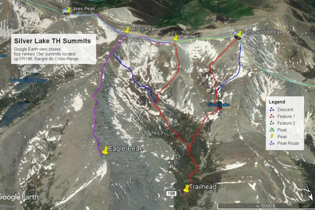
Silver Lake - Cloverdale Basin TH
From the town of Westcliffe, drive 11 miles north on SH 69 to just south of a "township" called "Hillside." At a substantial curve in the highway, turn west onto CR 198. This is easy to miss. The road first heads SW, then turns west. Follow this road for three miles to the Lake Creek Campground and the turnoff for a Lutheran camp close by. The Lake Creek Road # 198, is dirt and in good condition for about the first 3 miles to the camps. Just after the campground and turnoff for the Lutheran camp, the road becomes steeper and rocky and is only passable with a high-clearance 4-wheel drive vehicle. This road passes by Balman Reservoir and Rainbow Lake. Beyond Rainbow Lake, (if driving) extra caution should be taken as the road is narrow, rockier and becomes much more of a challenge to negotiate than the road to this point has been. We drove this road in 1995, then again in 2005. In that 10 year span, it only got a lot worse. In 1995, it was tolerable to Rainbow Lake. In 2005, we would describe it as though someone deliberately hauled in 2 - 6" cobble for a roadbed and dumped it all along the road. You can never go very fast. It is quite slow and tedious, though it is never very steep or offers large clearance problems, it is simply relentless. At one point above Rainbow Lake, the road crosses a boulder field with nothing to drive on but the moving rocks. There is one particularly tight switchback section to the right near some old cabins. In 2005, we were able to make the drive all the way to end of the road and the Silver Lake TH at 11,500 ft. in a Toyota T-100. It required a lot of careful driving. Silver Lake is about one mile from the trailhead. From the Lake Creek CG, it took us 1:45 to make the drive to the trailhead.
Camping
For a designated Forest Service campground, the closest is the Lake Creek CG, three miles in from SH 69 on CR 198. This is a fee campground with typical facilities, but no hookups. There are primitive camping sites at Balsam Reservoir. On the drive up to Rainbow Lake, there are primitive campsites that can be utilized and at Rainbow Lake, there is good camping close by. Above Rainbow Lake, the best camping opportunity will be near some old cabins at 11,260 ft. or farther up the road at the trailhead, across from some old beaver ponds.
-
From UN 13128 Lakes Peak
-
UN 13,128 NE Slopes Class 2 / 2.2 mi / 1,825’ One-Way
Open This Route in a New WindowOur hike begins in the vicinity of the trailhead with hopping across the stream to the south, then following a faint trail up the embankment and heading more south and walking by the edge of the forest. Following the advice of the two men from the evening before, we walked above and alongside the willow-filled area until the meadow narrowed and there was a beaver dam in the flat of the drainage. We followed a faint trail across the beaver dam which led us across the swamp and to the base of a forested terminus to the upper valley that lies between UN 13,128 and Eagle Peak. Hike up through the pleasant forest and after gaining about 200 feet, break out into the vast upper valley that is covered in lush grass, low willows and multitudes of flowers. The “pack trail” that shows on the survey map is only faintly visible in some spots. We did not attempt to follow it, but just meandered through the floriferous valley to about the 12,000 ft. contour. It was here that we crossed the small drainage on the west side of the valley and began an ascent in earnest to UN 13,128. The route we selected led up a shallow valley that descended from the summit to the northeast and emptied into the large basin between Eagle Peak and UN 13,128. Most of this ascent was moderately steep, but on easy, grassy slopes. It was not until the last few hundred feet that we encountered any rock and there was nothing of any great difficulty. This first summit can be gained quickly and easily once you find a way across the creek at the start and past the beaver ponds and willows. The upper valley is quite amazing and the west facing cliffs of Eagle Peak add a dramatic component to the view.
From the summit of UN 13,128, it's easily possible to continue north, dropping to a saddle, then up to Cottonwood, but we had completed Cottonwood 10 years earlier. So we sequenced UN 13,128 with a trip over Thirsty Peak, down the ridge to Lakes Peak, then returned north back to Thirsty, then followed the ridge out to Eagle Peak. This entire sequence we were able to complete in about seven hours.
-
Lakes Peak NW Ridge Class 2 / 1.7 mi / 1,020’ One-Way
Open This Route in a New WindowLakes Peak is sequenced with UN 13,123 with a start at the Silver Lake Trailhead in Cloverdale Basin. One way mileage and elevation gain are measured from the summit of UN 13,123. Round-trip mileage assumes completion of the sequence.
From the summit of UN 13,123, walk SE down the ridge to the saddle between it and Thirsty Peak. It takes about 15 minutes to descend to the saddle on mostly rocky terrain. The Garner Creek Trail that crosses at the saddle was quite visible when we hiked here in 2005. Continue SE, then more easterly to gain the summit of the unranked, Thirsty Peak. The 500 feet of gain trip up will be over mostly rocky rubble, but there's nothing too difficult. When you arrive at the summit of Thirsty Peak, you may want to study the ridge that extends NNE to Eagle Peak. That is the third summit in our suggested sequence.
From Thirsty Peak, continue walking SSE, quickly dropping down to yet another saddle, then heading back up to a longer, flatter section of ridge. Follow the ridge SSE, then it turns more to the SE to ascend some more to the summit of Lakes Peak. From Thirsty peak to Lakes Peak, it is more of an easy stroll on a sparse tundra/embedded rock mix with less rubble. On the ridge section south of Thirsty thta runs more north-south, there was a nice grassy area on the east side of the ridge and below the ridge that we took advantage of before regaining the ridge. The final section to the Lakes Pk. summit will become more rocky.
From the summit of Lakes Peak, you'll enjoy a tremendous view of the Brush Creek Basin and the two lakes. The upper basin is all tundra and in it, we spotted a large herd of elk. Some parties may want to consider going on from here to Electric Peak, nearly another two miles to the SE. Our sequence has you return from Lakes Peak to Thirsty Peak to begin the trip out to Eagle Peak over a two-mile long ridge.
-
Route Description
Year Climbed: 2005In our proposed sequence, you will return from Lakes Peak north back to Thirsty Peak before taking off on the connecting ridge to Eagle Peak. One-way mileage and elevation gain are therefore measured from the summit of Lakes peak to Eagle Peak by way of Thirsty peak. Round-trip mileage and elevation gain assume completion of the sequence.
From Lakes Peak, return NNW on the ridge that connects back to Thirsty Peak. The Lakes Peak route will provide information about this stretch of ridge, which never exceeds Class 2. As you approach Thirsty Peak, you may want to contour across the east face of the summit block about 200 feet below the summit to reach the connecting ridge to Eagle Peak and avoid going back over Thirsty. The most difficult aspect of this traverse will be the ridge that drops down to the Thirsty-Eagle saddle and climbing back up to the 12,907 ft. point. This section of ridge is very rocky, broken up and presents some minor route-finding problems. It is intimidating enough to make you look for an alternative, but there really is none. For a while, the ridge may drive you off the crest. Most of the time, we found ourselves on the north side and a little down. Typically, after allowing ourselves to be driven down, we later find that just a little extra effort to stay on the crest may have proven better. So, pick your own path here. As you approach the 12,907 ft. point, you may again be tempted to avoid going over it to save some unnecessary elevation loss, by contouring on the north side of the ridge. We found we still almost ended up on the summit of the little point.
From the 12,907 ft. point, the remainder of the ridge is a high altitude, long walk over mostly tundra until you near the summit where you'll encounter larger, flatter rocks. The views on either side of the ridge make the stroll very entertaining in regards to scenery. When we did this, we flushed out a nice covey of Ptarmigan along the way.
After you've taken a break and enjoyed the summit view, it is possible to follow the NNE ridge of the peak all the way down to Rainbow Lake. There is a climber's trail you can pick up once you enter tree, but this assumes you have left your vehicle in the vicinity of the lake. If you've left it farther up in Cloverdale Basin, then you will likely need to return along the ridge back in the direction of Thirsty Peak, though there is a report on LoJ of someone descending more directly from the summit back into Cloverdale. We returned along the ridge all the way back to the saddle or low point, working back through the rubble below Point 12,907, and then dropped north off the ridge into the upper basin below. From the vicinity of the low point of the saddle, we followed a shallow gully down that joined another gully about 1/3 of the way down. In between the two gullies was something of an "island," composed of a lighter-colored rock that was prominent from a distance and looked like dirty snow. Descend down this island of lighter-colored rock until it drops you onto an open, scree slope. This becomes the kind of scree where a few square yards may start sliding with you, but mercifully, it will all be over in about 15 minutes because after about 600 feet of elevation loss, you'll reach the basin and the nice tundra, grass and wildflowers. Empty the rocks out of your boots, then resume the hike down through the basin and try to follow the route you took up into this basin in the morning to make your way back to your vehicle and the trailhead. The best part of this return will be the wildflowers in the basin. In early August, this basin was filled with a vibrant and abundant display of aster-type flowers.
Alternate Circuit hike: Drive as far as Rainbow Lake. Ascend the NNE ridge of Eagle Peak. Follow the ridge from the summit of Eagle to Thirsty Peak, turn south to tag Lakes Peak then return to Thirsty Peak, walk NW to UN 13,123, continue NW to Cottonwood, then drop down to Silver Lake, locate the trail back to the trailhead and hike back down the road to Rainbow Lake.
Additional BETA
Links to other information, routes & trip reports for this peak that may be helpful. -