LoJ: #402 (Pre-LiDAR #399) / 13,303' East Buffalo Peak
Peak Summary
Here's an easy way to pick up two 13er summits ranked in the Top 400/500. The twin Buffalo Peaks offer an easy Class 2 walk-up ascent amid isolated terrain. These peaks do not have a direct connection to any other 13ers. With 4WD, this can be a "family-friendly," short-mileage hike with some possible wildlife viewing and probably no one else on the peaks. Passenger car access can lengthen the overall mileage significantly depending on your willingness to abuse your vehicle. Pre-Lidar elevation was 13,300 ft.
East Buffalo South Ridge Route
-
-
Buffalo Peaks Mine TH
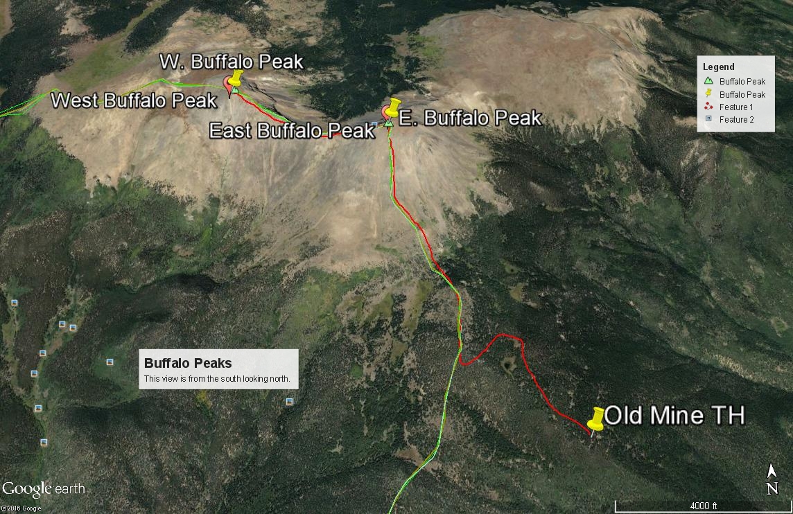
From Johnson’s Corner, a little over 2.5 miles south of Buena Vista, drive east and north on US285 over Trout Creek Pass and continue to the intersection of US285 and where US 24 heads of to the east at "Antero Junction." Continue north 1.9 miles on 285 to the turnoff to the west for the Salt Creek Road (FR435). If coming from Fairplay, drive appx. 19 miles south on US 285 to FR435. Follow FR435 4.5 miles west to a junction of FR435 and FR436. Go left onto FR436. The road climbs up a hill by a couple of switchbacks and at 2.1 miles from the previous junction comes to another intersection just before it crosses the South Fork of Salt Creek. Go ahead and continue over the creek on FR436. At the next two intersections, stay left on what becomes FR436-1A, then right (according to a recent source who corrected our directions). Follow the road to an old mining area and probably park at or above the mine about 2.8 miles from the creek crossing. Check our map link for an interactive map.
On FR435, there are any number of at-large campsites and on up FR436. Up to the intersection of FR435 & 436, the road should be fairly easy. Once on FR436, it will begin to degrade until it becomes mostly 4WD single track. It was not too rocky but showed signs of muddy potholes.
Route Description
Year Climbed: 1995East Buffalo Peak is sequenced with West Buffalo (Marmot Peak). It would make little sense to climb only one of these twin summits. There are also several ways these peaks can be approached. What appears to be a preferred route for Front Range peakbaggers is to drive in eight miles on FR471, which is 12.4 miles south out of Fairplay on US285. The trailhead used for that access is the Lynch Creek. There is also a direct access out of Buena Vista on a combination of County and Forest Service Roads 371 and 375 to the Four Mile TH. There are multiple reports of these other routes on SummitPost and 14ers.com. The access we used in 1995 offers a third option but is best done with 4WD. While we did not find the road access to be particularly rugged, a 4WD vehicle would offer the most assurance of making it to the old mine site near 11,320 ft. Also be aware that there are some private property inholdings in this area and respect them, especially if camping.
From the car park, probably at or near the old mine, continue following the old roadbed as it heads north, then west to gain the broad south ridge of East Buffalo Peak. Once on the ridge, follow it to the east summit on mostly grassy tundra observing the enormous giant thistles that seem to prefer this area. Higher up the tundra will give way to steeper & looser rock, kind of a combination of larger boulders somewhat embedded in the grassy tundra and then, even more loose rock on a steeper slope higher up. Both summits are volcanic in origin. You may want to identify volcanic features as you make this hike. There may be game/goat trails that will lead through the rock. As you near the summit ridge, the angle of ascent will become more tolerable and you can finish on tundra to the large, somewhat flat summit covered in tundra and embedded rocks. From this summit, most will want to continue northwest to West Buffalo Peak.
If you don't like the direct ascent up the south ridge of East Buffalo, it is reportedly easier to head toward the saddle between the two Buffalo summits. From the saddle, follow the connecting ridge to each summit, then return by the same approach. This will involve more mileage (not a significant amount) & contouring.
Additional BETA
Links to other information, routes & trip reports for this peak that may be helpful. -