LoJ: #64 (Pre-LiDAR #63) / 13,942' French Mountain

Peak Summary
French Mountain is a fairly easy Class 2 summit with a ranking in the top 100 Colorado peaks. However, the hiking mileage without 4WD is fairly long, especially when Frasco and Casco are included in the day, which is typical for a climb of these peaks. At least a stock 4WD is recommended to reach the trailhead for climbing any of these peaks. Short bed, high clearance 4WD can get you much farther up the South Halfmoon drainage and shorten the hike.
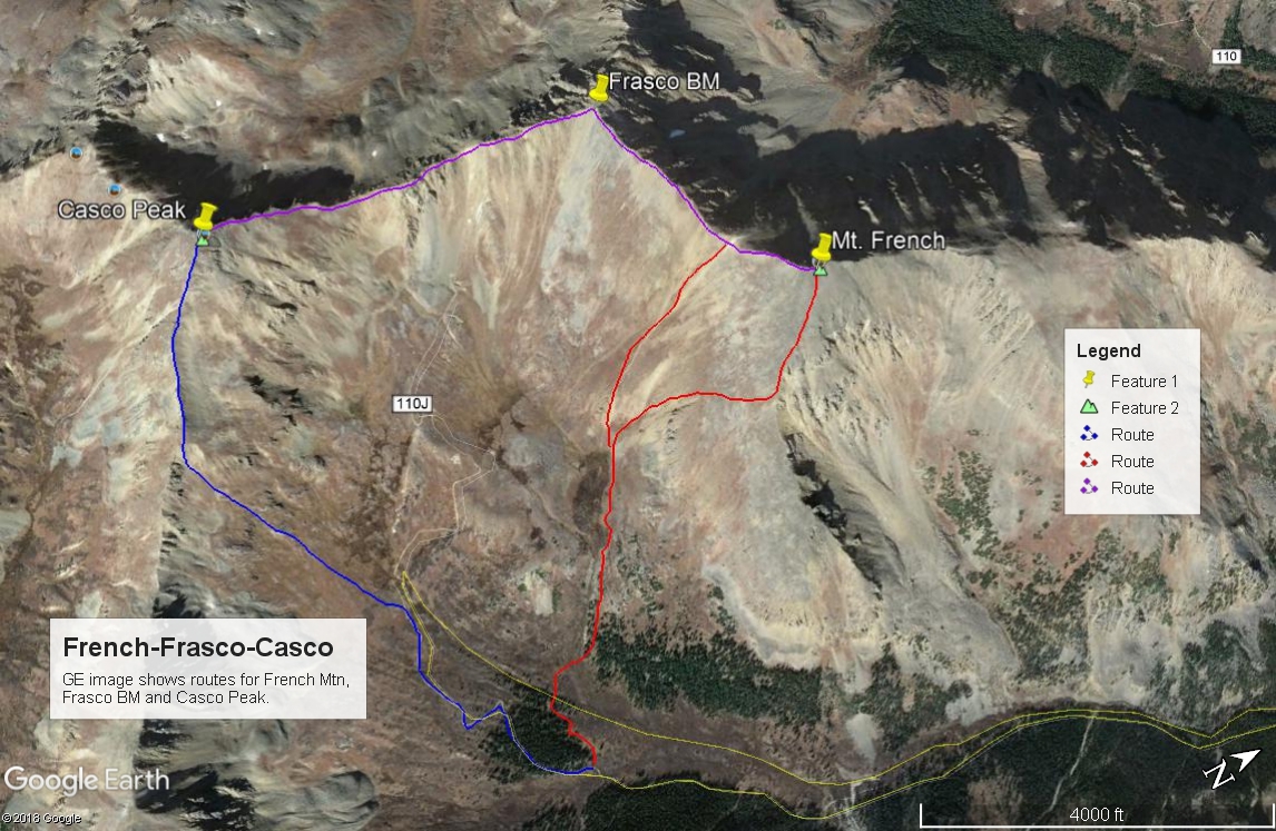
French Mtn. SE Ridge & flank Route
-
-
South Halfmoon Creek TH
From the town of Leadville, drive about 3 miles WSW on US24 to where the highway makes a sharp tunr to the south. At the intersection here, turn west onto CO300, cross the railroad tracks and drive .8 mile west to another intersection. Turn left (south) onto CR11 and drive 1.3 miles to another intersection where you will bear right, remaining on CR11 which in time will become FR110. Continue SW on the graded, gravel road for another 5 miles eventually passing the Half Moon East and West Campground and the Elbert Creek CG. About .3 mile west of the Elbert Creek CG is the trailhead for Mt. Massive, appx. 7 miles in from US24. (N 39° 09' 05.87" W 106° 25' 09.77") The Mt. Elbert TH is located just south of the entrance for the Elbert Creek CG. (N 39° 09' 08.40" W 106° 24' 43.25") If you do not have a vehicle with better clearance, you'll need to park at the trailhead. Otherwise, FR110 continues west for another 2.1 miles to the intersection for FR110J (aka" 1103A). While this last two miles is rated 4WD, having that capability is not as important as having better clearance.
Drive south on FR110J (aka: 1103A) dropping down to Halfmoon Creek. Before crossing the creek, there's an unofficial trailhead. Our hiking route description begins from here. If you have a short wheel base, high clearance 4WD, it's possible to drive a little over a mile up FR110J to where it crosses South Halfmoon Ck. This crossing has for years stopped any number of 4WD vehicles - especially longer base ones. In 2004, our son-in-law tore the bumper off his Jeep Cherokee attempting to cross the creek here. If you have the skills and the vehicle and can get across, the remainder of the road up into the basin is not too terribly bad and you can save some significant mileage. Otherwise, you will have to park at the creek crossing and there's precious little room for doing that and it's not easy to turn around either. Best advise, park back down on either side of Halfmoon Creek and walk the road.
Camping
There are three Forest Service campgrounds along Halfmoon Creek. They are Half Moon East, Half Moon West and Elbert Creek. Information about these campgrounds can be found at this link: https://www.forestcamping.com/dow/rockymtn/sicmp.htm. These campgrounds usually max out on summer weekends. All three are listed as "first-come, first-served," so no reservations accepted. Driving west on FR110 past the Mt. Massive TH on the 4WD road will offer some additional at-large camp spots as you continue up valley. There is a sizable area for at-large camping where FR110J (1103A) turns off for South Halfmoon Creek.
Campsite Locations
Elbert Creek › N 39° 09' 09.16", W 106° 24' 48.74"10,075 ft.Half Moon West › N 39° 09' 27.30", W 106° 23' 52.32"9,950 ft.Half Moon East › N 39° 09' 32.36", W 106° 23' 48.64"9,935 ft.
Click thumbnail to view full-size photo + captionRoute Description
Year Climbed: 1994French Mountain is the first summit in a sequence that includes Frasco BM and Casco Peak. The trailhead begins at the crossing of Halfmoon Creek. Only short-bed, high clearance 4WD should attempt to drive up FR110J, mostly because of the crossing of South Halfmoon Creek. Some stock vehicles may make it as far as that crossing, but historically, the crossing of the creek has been very rough and has turned many a vehicle back. Unless a bridge has been rebuilt, you will also have to do a low-water crossing of Halfmoon Creek, which in runoff season can be a dangerous proposition. Use good judgement. Discretion is the better part of valor.
From the trailhead, cross Halfmoon Creek. Our last visit here in 1994, there was still one log across the creek left over from the remains of an old mining bridge. Walk south up FR110J which gains about 200 feet in elevation above Halfmoon Creek before beginning a long switchback to the west and then back SE, before heading more south again for the crossing of South Halfmoon Creek. That crossing is about 1.1 mile up from the trailhead. Find your way across the creek (wading, jumping, rock-hopping, etc) and continue up the road. On our last visit in 1994, there were still some old logs here to cross on from an old bridge. Hike a total of about 3.6 miles to an elevation of about 11,725 ft. There's a brief opening here between the trees. On the USGS map, this will be the last group of trees the road passes through in the basin. Turning off the road to the west, just after crossing one of the branches of South Halfmoon Creek, utilize the trees to avoid willows and cross the next branch of South Halfmoon Creek. The willows here are at least not the "man-eating" type. Work your way WNW about 100 feet in elevation up the hillside through willows to another group of trees. Staying on the north side of yet another stream and in the open trees will help you avoid willows. Follow along the stream to an area where things level out at about 12,300 ft. There's a large collection of willows here that can be avoided by hiking on the north side. Hike to the west end of the willows where the slope up to Frasco BM and French steepens (12,450 ft.). Here, you can make a choice.
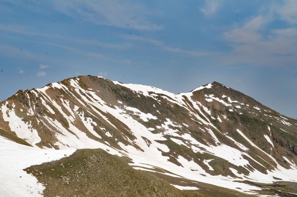
Some will want to head directly up to the French-Frasco saddle and from there, turn right to reach the summit of French. This is a good choice but will lead to some redundant ridge walking. The slope up to the saddle is mostly low, grassy tundra. If you wish to avoid doing the ridge walk from the French-Frasco saddle twice, you can head uphill a little more to the right from the end of the willows and aim to intercept the SE ridge of French by hiking up the south flank of French. There will be some obvious rock outcrops and set of gullies to avoid, but most of this slope will also be on low, grassy tundra until you've gained the SE ridge. Once on the SE ridge, the terrain becomes more rubbly with patches of low tundra, rubble and scree before arriving at the rockier summit. All very typical Sawatch terrain. The summit of French will offer an impressive view of the Mt. Massive complex. You'll also be able to examine the connecting ridge over to Frasco, then Casco.
Additional BETA
Links to other information, routes & trip reports for this peak that may be helpful. -