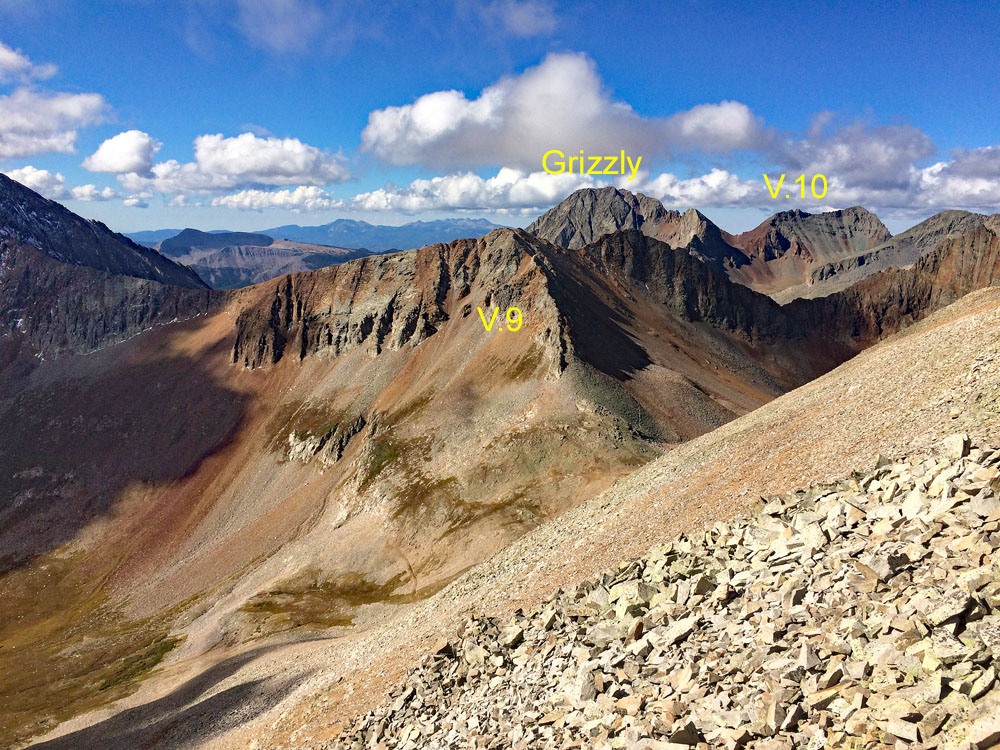
LoJ: #126 (Pre-LiDAR #134) / 13,753' Grizzly Peak Grizzly Peak B

Peak Summary
This Grizzly Peak is by a route on its south ridge a basic, Class 2 walk up on plenty of rubble so typical of this entire area. The summit provides a great view of the southern peaks on the Ophir quad. The trailhead is the same as one of two that are used for V.10 and is best accessed with a 4WD or higher clearance vehicle. The drive in begins at the Durango Mountain Ski Resort. Depending on road conditions, cross-over style vehicles may make it to the TH if they have better than average clearance.
Grizzly Peak B South Face Route
-
-
Durango Ski Mtn. - Cascade Creek TH
This alternate route to the trailhead above Cascade Creek for Grizzly Peak B and V.10 brings you in from the Purgatory/Durango Mountain Resort & Ski area. It is the approach we would recommend for climbing Grizzly Peak B. From Durango, drive north on US550 about 28 miles to the Durango Mtn. Resort and turn west on Hermosa Park Road. (From Silverton, drive south on US 550 for about 22 miles. Follow this dirt road (so it was in 2002) to where it intersects a paved road that's part of the resort and take a sharp right, go a short distance and keep going straight onto a dirt road. This is still the Hermosa Park Road #578. Proceed on a series of switchbacks that climb above, overlooking the resort. At the next intersection, a sign mentions a campground, the Hermosa Creek trail and Ebert Creek Road. Go right. In about another half mile, go right, turning onto the Relay Creek Road (CR38 or FR578) After a quarter mile, stay left. A mile and a half later, turn right for the Cascade Divide Road, FR579, instead of continuing on Relay Creek. You should now be on the correct road - FR579. (On Google Earth this is designated as the Cascade Divide Road.) In a few more miles it passes through a gate and from there it's 8 more long miles to the road terminus. The road becomes much rougher after the gate. Higher clearance is preferred. The road is slow enough to drive that biking it on a mountain bike would not be much slower. It took us around 1:20 to drive in the 15 + miles to the abrupt roads end. If these directions do not work, you could try the last edition of G & M and follow the directions for Grizzly Peak B. On the San Juan National Forest map, this clearly shows as FR579, which is shown connecting to the Colorado Trail. The same road does show on the Trails Illustrated map # 141, but only the last few miles. You would nee TI #140 to see the rest of the road from it's start at Durango Mtn. Resort. This road does not show at all for most of its last eight miles on the older USGS quad. If using our CalTopo maps, use the FS2016 version to see the entire road approach.
The road ends at these coordinates: N 37° 43' 31.26" W 107° 51' 42.46". Elevation is 11,230 ft. In the last two miles, the road goes through twpo pairs of switchbacks. You can primitive camp here or back down the road a short distance, or at other spots along the drive in. The end of the road constitutes the trailhead, but it should be noted that if you hiked up the hill to the west about 100 feet in elevation, you would intersect the Colorado Trail. The better way to get to that trail is to hike from the end of the road NW along a trail that in a couple tenths of a mile will intersect the Colorado Trail without climbing up the hill. Once northbound on the Colorado Trail, you are headed the right direction.
Camping
As noted above, it's easy to car-camp here or set up a tent nearby, or go back down to one of the switchbacks where you may find more room to park and set up a tent if desired. We also utilized a campsite near what was either Graysill Creek or EZ Creek - not sure exactly which one.
Click thumbnail to view full-size photo + captionRoute Description
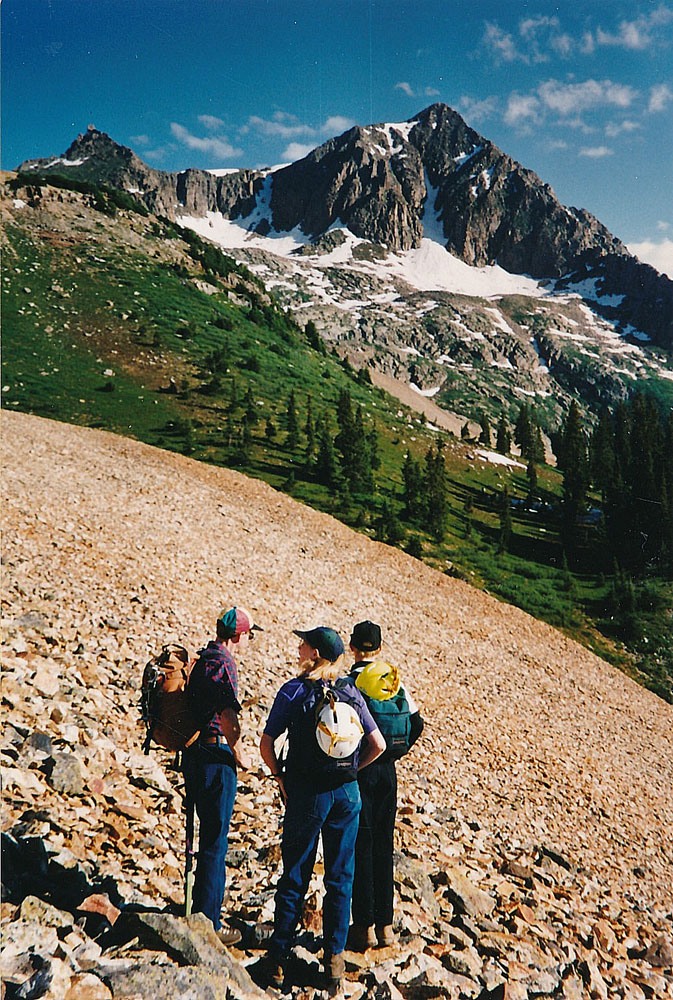
Year Climbed: 1995From the abrupt end of FR579 walk NW on a trail that takes off from the end of the road and continue on a NW contour on that trail into the trees until it intersects the Colorado Trail after about .2 mile and shortly before the Colorado Trail drops down to cross an unnamed fork of Cascade Creek. On some maps, this trail use to be called the Rico-Silverton Trail. Once you find a way to cross the creek (may be more of a problem earlier in the season) follow it east to these coordinates: N 37° 43' 47.19" W 107° 51' 41.32". Here, another, less used trail heads off contouring east uphill above the Colorado Trail. Follow this trail through open terrain for a while as it heads more steeply uphill, then turns north onto a bench area at just about tree line. The trail crosses a brief scree field, goes a short distance, then comes to the tongue of a large rock glacier. It crosses through it at about these coordinates: N 37° 44' 09.63 W 107° 51' 19.53". The trail continues on the timberline bench to yet another rockslide area. If you attempt to skirt at the bottom, you will find willows. If you don't like that choice, walk across the bottom end of the rock glacier. Choose your poison. Once on the other side, the trail will continue to an unnamed pond/lake at 11,560 ft. Backpackers will find some nice camping here.
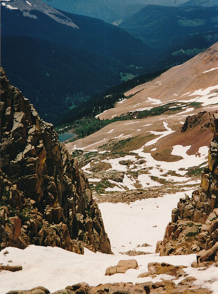
Now the fun begins. From the unnamed lake, to the west will be yet another rock glacier that you'll want to avoid. Looking at the summit of Grizzly, you will see a large cleft-like couloir almost directly below what appears to be the summit. Follow the west (left) skyline ridge down past a rocky buttress to yet another prominent couloir. That is your basic destination. Ascend by the best route you can find in a NW direction to a small basin at 12,140 ft. On the map we supply, this is about where the ascent and descent routes intersect. Hike in the direction of the couloir mainly on grassy slopes with rock outcrops interspersed. Enter the couloir at about 13,100 ft. Earlier in the season, the couloir will still be filled with snow and a minimum of an ice axe will be welcome. If there is no snow, then it is all loose rubble. We climbed this summit on July 29, 1995 and found the couloir filled with snow. 1995 was a particularly heavy snow year in the mountains.
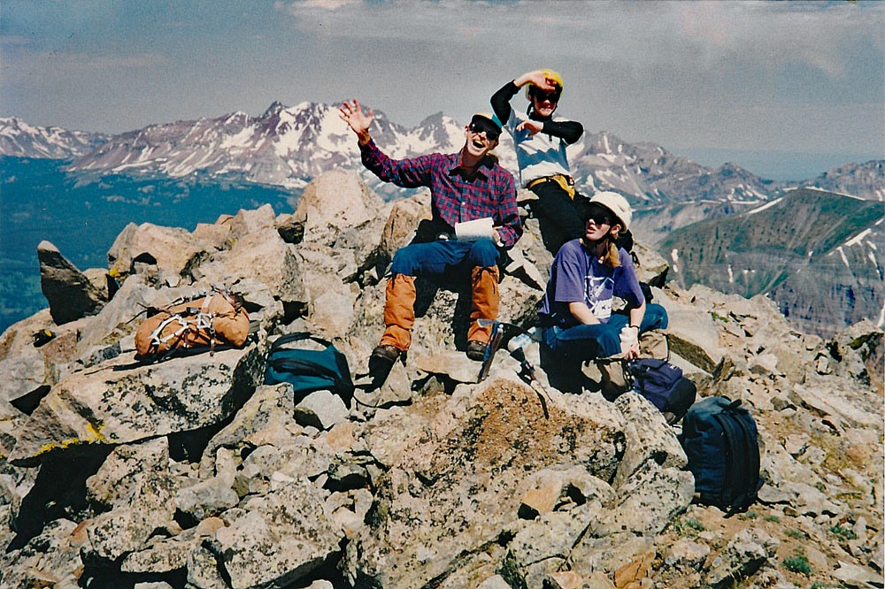
Slug your way up the couloir and top out to find a moderately tilted, wide open slope of mostly small scree/rock and patches of snow earlier season. Follow the south ridge toward a false summit then head left over to the high point following the ridge line for a little bit of scrambling at the end where there is a little false summit that requires scrambling down some and then re-ascending to the true summit. The summit is mostly comprised of large blocks of rock. The north face of the peak drops off precipitously. The ridge that connects to V.10 holds nothing enticing. There's an outstanding view of the large basin at the head of Cascade Creek. From here, you could enjoy views of the Needle Mountains, Grenadiers, La Platas and Dunton Meadows.
For the descent head back as you came or try the following: Walk back down the Class 2 south ridge that you came up and continue past the head of the access couloir. Continue along the ridge on large blocks of rock with tundra ledges in between. The ridge leads to a small, pinnacle-like summit which you may want to climb for the pure fun of it. Contour around the pinnacle on its east side and then begin to drop down to a broad, grassy slope which will lead directly south and will eventually connect back to the ascent route. Just stay away from and off the rock glacier. We completed this climb with our kids, ages 12 & 14 at the time in a little over six hours.
Additional BETA
Links to other information, routes & trip reports for this peak that may be helpful. -