LoJ: #79 (Pre-LiDAR #78) / 13,867' Jones Mountain (A)

Peak Summary
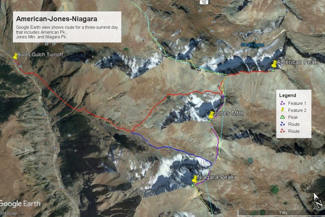
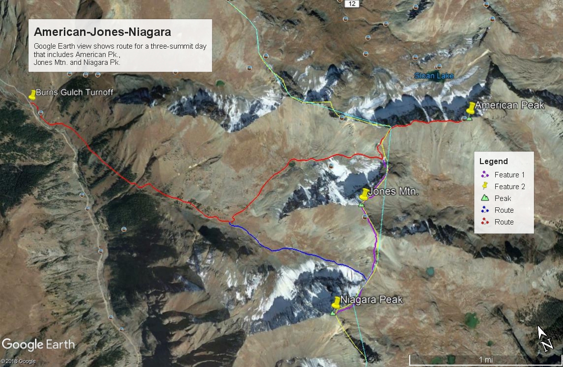
Jones Mountain A is the second summit in a sequence of three that includes American and Niagara peaks. Jones is a fairly steep and rugged Class 2 hike from American Peak. Our suggested trailhead goes up Burns Gulch. Access is from the road up the Animas River NE of Silverton. A 4WD is not required to reach the suggested trailhead and most crossover SUV's could make it to the start. A 4WD vehicle can be driven a couple miles up Burns Gulch saving both mileage and elevation gain. Jones may also be accessed from either Cuba Gulch to the east of the summit or American Basin, north of American Peak and accessed from Cinnamon Pass.
Jones Mtn. NE Ridge Route
-
-
Burns Gulch TH
From the Town of Silverton, drive east to where the paved road splits one block past the courthouse and veer right onto blue-signed County Road 2 (set odometer here) for 4.2 miles of nicely graded dirt road to Howardsville. (On Trails Illustrated map #141, this road is labeled #110. Pavement ends after 2 miles.) From the Howardsville intersection, continue north another 4.3 miles to the old site of Eureka. The road will cross to the west side of the Animas River and continue up a steeper shelf section. From Eureka, continue another 3.5 miles to the turnoff for Burns and Grouse Gulch. It is possible to do a low water ford of the Animas about .2 mile before reaching this point and head on up Burns Gulch if water levels in the Animas allow. However, if you stay on the main road, it will cross back to the east side of the Animas on a bridge. Most cross-over type vehicles should be able to make it to here. (See coordinates) If you do not have 4WD with good clearance, park in the vicinity and follow a spur road back south on the east side of the river that will connect shortly with the Burns Gulch road. Hike or drive the road all the way to about 11,680 ft. where it forks. The road is a single-lane, rocky & moderately rough 4WD track and lower down follows along a shelf where meeting another vehicle coming down can be problematic. There may be a couple places to camp up in the gulch.
Camping
There are no forest service, designated campgrounds along the Animas River to the trailhead, however, at-large camping can be found in numerous locations. Be aware of private property and watch for postings and please dispose of waste properly.
-
From American Peak
Open This Route in a New WindowOur route description assumes hikers do not have access to higher clearance 4WD that would enable driving up Burns Gulch. If you do have such a vehicle and don't mind the rocky drive, you can save 2.0 miles one way and over 900 feet in elevation gain from the figures that we provide.
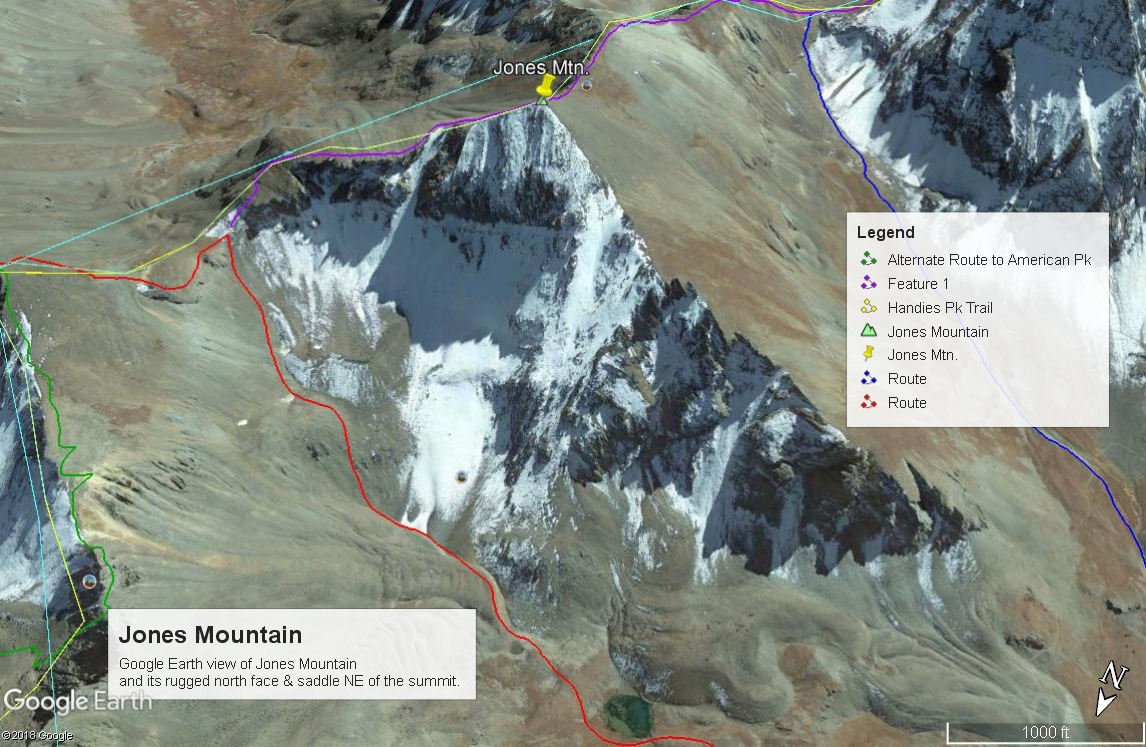
From the Burns Gulch TH coordinates, walk south on the east side of the Animas for about .2 mile to intersect the actual Burns Gulch Road. Follow this road as it makes an ascending traverse to the SE, heading up the gulch. If driving, the shelf section is a narrow, single-lane track where it would be best not to meet an oncoming vehicle. Father up, an older set of switchbacks that show on the USGS map are now bypassed. Continue hiking/driving to a main fork at about 11,680 ft. If driving, park in the vicinity. Hike up on mostly tundra/grassy terrain into the NE fork of Burns Gulch, staying left/west of the tongue of a large rock glacier. Old roadbed may be utilized for the first half mile. At 12,520 ft., there is a very small lake. Continue east past the lake on more tundra for a short while and begin the talus scramble to the saddle between Jones and the west ridge of American. The hike will steepen considerably, and the talus becomes more unstable, turning to loose scree and dirt. There appears to be on Google Earth a trail of sorts established through here now.
Once at the saddle, head north to the third point west of the American summit. This is basically where the ridge-line will take you. If you have viewed American from the Cinammon Pass side, you may be wondering how the ridge east to the actual summit will fare, because on the north side of the ridge, there are precipitous drops. As long as you stay on the south side of the ridge crest, there will be no serious problems other than all the unstable talus, rocks & boulders to cross which will definitely slow progress. Contour at about the 13,600 foot level to avoid the ups and downs. Once again, Google Earth now shows braided trails running east along and below the ridge crest to avoid the three "bumps" all the way to the actual summit. The coordinates provided do not correspond with what GE shows. About 120 feet of mountain are missing on GE - not unusual for summits with cliffs on one or more sides.
Click thumbnail to view full-size photo + captionRoute Description
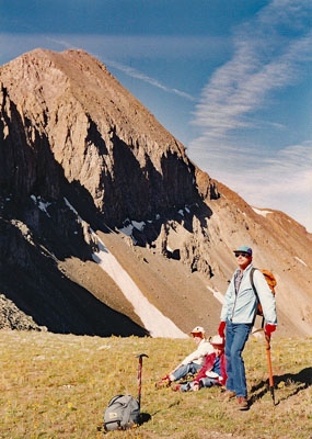
Year Climbed: 1991Jones Mountain is second in a three-summit sequence that begins with American Peak. One way mileage and elevation gain to Jones are measured from the summit of American Pk. Round-trip mileage and elevation gain assume completion of the sequence. The entire sequence assumes a start from the bottom of Burns Gulch at the Animas River and also assumes hiking up the road into Burns Gulch. Two miles of hiking, one-way may be eliminated along with 900 feet of elevation gain if you have a 4WD vehicle that can make it up Burns Gulch.
From the summit of American Peak, make your way back WNW carefully along the teetering talus from the summit of American Pk. Use trails will keep you away from the ridge crest and help avoid some of the unnecessary ups and downs that can make this a longer day. At the third hump, descend back to the Jones/American saddle at 13,340 ft. On the descent, there is at least a little bit of tundra.
From the saddle, mount the rocky ridge-step that blocks the way to the NE ridge to the summit. This ridge-step is the most difficult part of the 520 ft. ascent. It's basically a Class 2 effort, but some might call it Class 2+. A use trail through here will expedite your progress. Once above the ridge-step, the ridge "levels" out some for a while, passes a notch with a large, steep couloir that drops to the north, then makes the final, steeper ascent to the summit, still on mostly talus & rubble.
Additional BETA
Links to other information, routes & trip reports for this peak that may be helpful. -