LoJ: #91 (Pre-LiDAR #92) / 13,838' Jupiter Mountain
Peak Summary
Jupiter Mtn. SW Slopes Route

-
-
Needleton Bridge TH
To begin with, there is no vehicle access to Needle Creek, Ruby Creek, Noname Creek, Tenmile Creek or Elk Creek. The only means of getting to any of these drainages is an excessively long backpack from the nearest pavement, or a ride on the Durango-Silverton Narrow Gauge Railroad. There's plenty of information available on the internet regarding use of the train. This "trailhead" description will therefore deal with a few useful hints for utilizing the railroad to get to Needleton and from there, to Noname Creek, Ruby Creek, NW Pigeon Creek and Needle Creek/Chicago Basin. In regards to 13ers, the Needle Creek trail will provide the easiest access to Jupiter Mtn., Peak Eleven, Glacier Point and possibly Grizzly and McCauley if you're willing to hike over Columbine Pass. The Ruby Creek trail will provide the easiest access to Pigeon, Turret, Peak Fifteen, Peak Twelve, Monitor, Peak Thirteen and Animas Mtn. The Noname Creek trail will provide the easiest access to The Heisspitz, Peaks Four, Five and Six. Additionally, some people use Noname to approach Jagged and Knife Point, Peak Ten and Peak Eleven and even others.
Ahh. The famous narrow gauge railroad ride. How many times we've paid for that trip. Twice we've reserved tickets months in advance, laboring under the impression that was the only way we could get a ticket, only to have our trip rained out by relentless monsoon. At todays train prices, that's no small loss. So here's a few hints. First of all, you don't always have to catch the train in Durango. At least in some years, they will allow boarding from Silverton, but always check ahead on this because they've changed their policy more than once. We finally discovered in 2009, that not only could we board the train there, but we could show up the day of our departure and purchase tickets without any advance reservation. We just walked over to the train station and made the purchase and in doing so, also saved about $10 per ticket. But be prepared to still pay mostly full, round-trip price because they were no longer prorating tickets based on where you may get dropped off. (That was a long time ago.) The reason you can purchase same-day tickets is because they can almost always squeeze you on somewhere, likely in one of the open cars where you may have to stand the entire ride. But hey - it beats packing in all those miles and it only takes an hour to go from Silverton to Needleton. By purchasing same-day tickets, you can be more flexible and schedule a backpack trip when the long term forecast appears more promising. The times we've done this, the train departed Silverton about 2:45 PM and dropped us of by 3:45 PM.
NOTE: As of 2021, we have been informed that you cannot board the train in Silverton and get dropped off at Needleton. The only stop on the southbound trail in the afternoon is Elk Park. For further details, follow this link to the railroad website: https://www.durangotrain.com/w...
Now here's the next hint that specifically relates to the Noname Creek drainage. We found in 2012 that it was possible to persuade the engineer to allow us to get off the train when it stops at the "Needleton Watertank," to re-supply with water, a little over a mile north of the Needleton drop. He had us stash our packs under a seat on one of the cars instead of throwing them into the baggage car and had us make a quick departure when the train stopped so as not to delay it any. From that drop point, we were able to a walk north, off, but along the tracks, until we came to a spot across from Noname Creek where we could ford the Animas. Doing this saved the over two mile long and difficult hike from Needleton on the east side of the Animas that goes up and over "Watertank Hill." It also saves the difficult task of following the sometimes obscure trail that can be easy to lose in a place or two, and it saves a considerable amount of time. But there is one caveat - in many years, it will not be possible to ford the Animas River until August some time, if even then. To discern if it's possible to do so, we used stream flow data to determine the CFS river volume. Our advice is that the streamflow must be under 150 cfs. Use the following link to make your determination: waterdata.usgs.gov. Note: Again, as of 2021, this strategy is probably not possible, which means the best access to Noname Creek will be from the Needleton drop.
Keep in mind this measuring station is upstream from Noname Creek. If you ford the Animas below where Noname comes in, the flow will be even greater. Heavy, monsoon rains can increase flow dramatically. If you do choose to ford here, we are not responsible for your being swept away. If you have an ice axe with you, use it along with another sturdy stick in the other hand. Unlatch all straps on your pack so if you fall in, you can free yourself of the pack and avoid being pulled under. Bringing some sandals for the crossing is helpful. Wear shorts, zip-off pants, or strip down. If you cross below where Noname comes in, leave boots off when you get across because you'll need to wade Noname Creek as well. We crossed a little downstream from Noname at a spot where the Animas widened out a little. Approximate coordinates are: N 37° 39' 37.41" W 107° 40' 44.59" Good Luck!
Camping
At the Needleton drop, cross over on the footbridge and if you head south toward Needle Creek, there are numerous camping opportunities past the last cabin. You can also hike north, past the cabins and find several other camp locations beyond the private property of the cabins in meadows after crossing Pigeon Creek.
-
From Needleton Bridge TH via 11,000' in Chicago Basin
The Needle Creek to Chicago Basin Trail is an old, very-well established and highly used trail. After the first .8 mile, it heads up Needle Creek and gains steadily all the way into Chicago Basin. Compared to many other Weminuche trails, this one is tame. This is the easiest way to reach Chicago Basin if a train ride is in your budget.
From the Needleton footbridge, cross to the east side of the Animas River and follow a trail south for.8 mile to a signed, trail intersection. A trail coming in from the south is the Animas River trail. That's the only foot path way into here if you don't want to pay the train fare. At this intersection, make a left and head up Needle Creek, on the north side of the creek, where the trail stays for the entire journey up to Chicago Basin. At 2.5 miles from the east side of the footbridge, is a trail turnoff for Emerald and Ruby Lakes. Neither the most recent San Juan National Forest map or the Trails Illustrated map show this any longer, but it is on the USGS quad. (This is where the stream from New York Basin comes in on the left.) That would indicate the trail is no longer maintained and may be difficult to spot. There use to be some campsites nearby. If you want to access those lakes now, you're probably better off coming in from Endlich Mesa, because the bottom portion of this trail, as it climbs above Needle Creek, crosses a half dozen avalanche chutes where the trail could have been easily obliterated by now. We are working on seeing if we can obtain any current information on its status.
Beyond where the stream from New York basin comes in, continue another 3.5 miles to the 11,000 ft. elevation in Chicago Basin, where one of the two trails for Columbine Pass heads off to the east. We are designating this as the terminus for the approach. There are campsites well before arriving here and of course, campsites further up in Chicago Basin. We have received reports that beetle kill has devastated the trees here. There has been a campfire ban in place for years. In July and August and even past Labor Day, this area can be crowded with climbers heading for the 14ers. Weekends can be even busier and you can expect competition for campsites. If you have the energy, you may be better off if you can push up either of the two trails toward Columbine Pass and camp at 11,680 ft. where the two trails merge. There are good campsites there.
Open This Approach in a New Window
Route Description
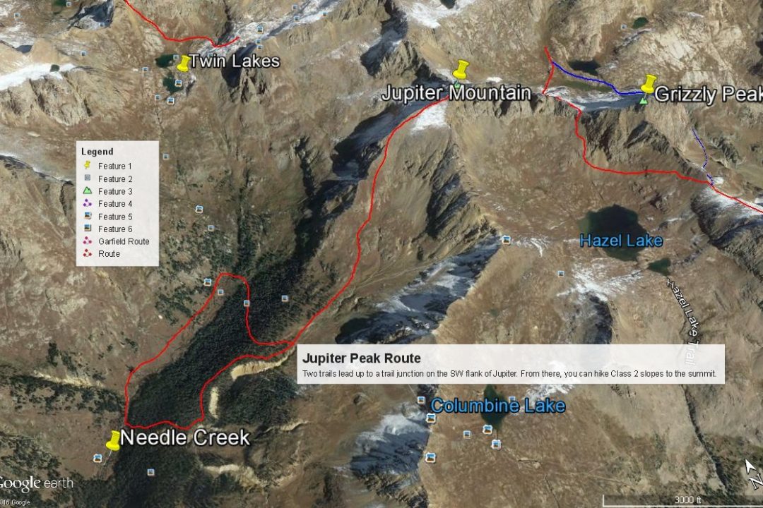
Year Climbed: 1987The bottom portion of the route for Jupiter uses trail. From 11,000 ft. in Chicago Basin, there are two trails that can be taken. Both will intersect at 11,680 feet. The first trail departs the main Chicago Basin Trail at 11,000 feet at a confluence of Needle Creek and an unnamed creek coming down from the SE. To reach that trail, you must cross Needle Creek above the confluence. The trail climbs steeply on switchbacks above an entrenched gorge, working generally SE and east to the junction at 11,680 ft. Neither the San Juan NF map or the Trails Illustrated map show this trail. The USGS quad does. For more detail concerning this trail, see "Colorado's Thirteeners" by G & J Roach. The trail is also mention in G&M.
For the "Official" trail, keep hiking up the Needle Creek trail to the head of Chicago Basin at 11,200 feet. Watch for the trail turnoff to the east that crosses two forks of Needle Creek. Do not be drawn up the climbers trail to the twin lakes between Eolus, Sunlight and Windom. The trail passes some good campsites here, then begins to switchback east some before making an ascending traverse south to the trail junction at 11,680 ft. This is the trail we used in 1987.
From the trail junction at 11,680 ft., begin hiking off the main trail up a large basin with lush grass, tundra and wildflowers to the ENE and the bottom of the steeper SW slope of Jupiter. Stay left of the main drainage where water may still be running. Continue NE up the steeper slope avoiding rock outcrops on more tundra/grass mix. At about 13,400 feet, you will likely come close to the Jupiter west ridge. Follow either the ridge or slope to a false summit. To this point, it's all been at the worst, steep Class 2. Getting to the true summit is where it earns the "+" rating. This last brief section will involve some route finding and minor scrambling through short gullies and larger rocks/blocks. The true summit is the westernmost of several "towers" along an east running ridge. Climbers wanting more detail can consult the Roach book again.
We provide the following as a gauge for climbers making the Chicago Basin trip. In mid-August of 1987, Carrie had about five 14er summits to complete the 14ers. We embarked on a multi-day backpack trip beginning from the train to Needleton, accompanied by our children, ages 4 and 6, and Bob Alden, our frequent climbing partner. We hiked up the trail to Chicago Basin, found a suitable campsite at the south end of the basin and then watched it rain almost continually for the next four days from our tent. On about day three, Bob and Tim decided to attempt Jupiter, which was Bob's main motive for this portion of the trip. Starting out in light rain, the two continued up the trail and began the main ascent where you leave the trail. As they ascended the rains increased until they finally stopped and questioned the sanity of going on. Tim's response was, he would prefer to not be a headline in tomorrows paper, so they gave up and returned to camp. After 4 days of rain, they gave up and packed out.
Disappointed at that failure and having paid the train fare for nothing, Tim and Carrie returned two weeks later over Labor Day weekend with a more promising forecast. Once again, they shelled out for the train ride, rode to Needleton and backpacked not only all the way into Chicago Basin, but up to the twin lakes where they set up camp. (It was legal back then). The next day, with much better weather, they climbed all three 14ers and returned to the same camp. The next morning, they packed up their tent, descended back to 11,200 ft. in Chicago Basin, ditched the backpacks and climbed Jupiter by the route described above. They then descended, packed out and caught the train back to Durango. So in three days, it's possible to do all three 14ers and Jupiter. Carrie went on to complete her remaining 14ers just a couple weeks later. The moral of this story? Weather makes all the difference.
Additional BETA
Links to other information, routes & trip reports for this peak that may be helpful. -