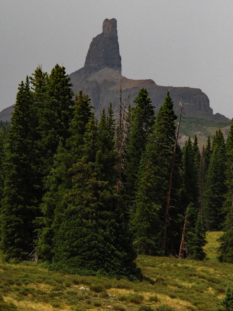
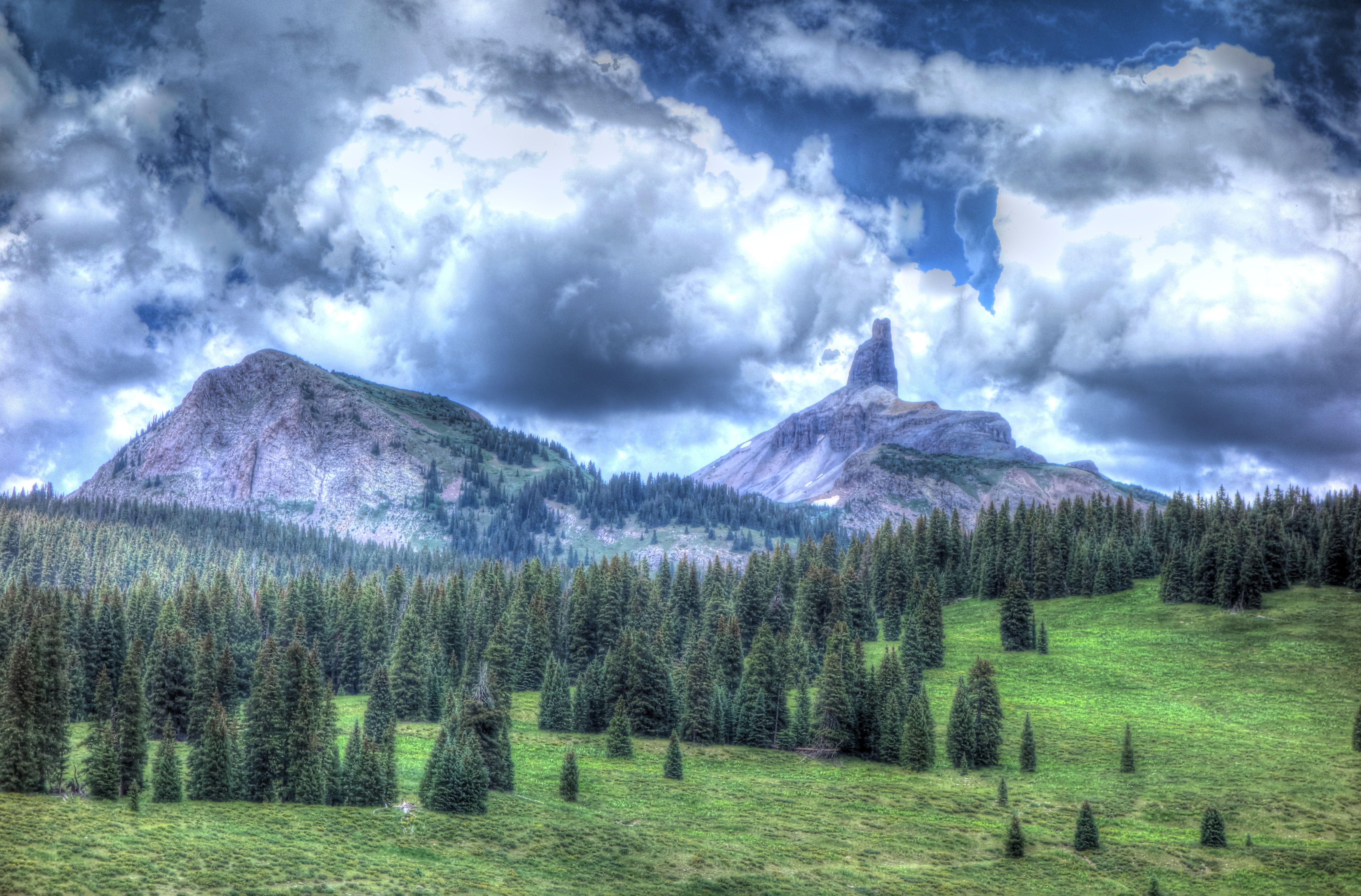
LoJ: #559 (Pre-LiDAR #556) / 13,112' Lizard Head
Peak Summary
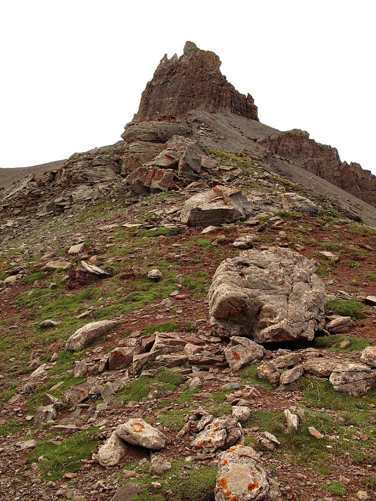
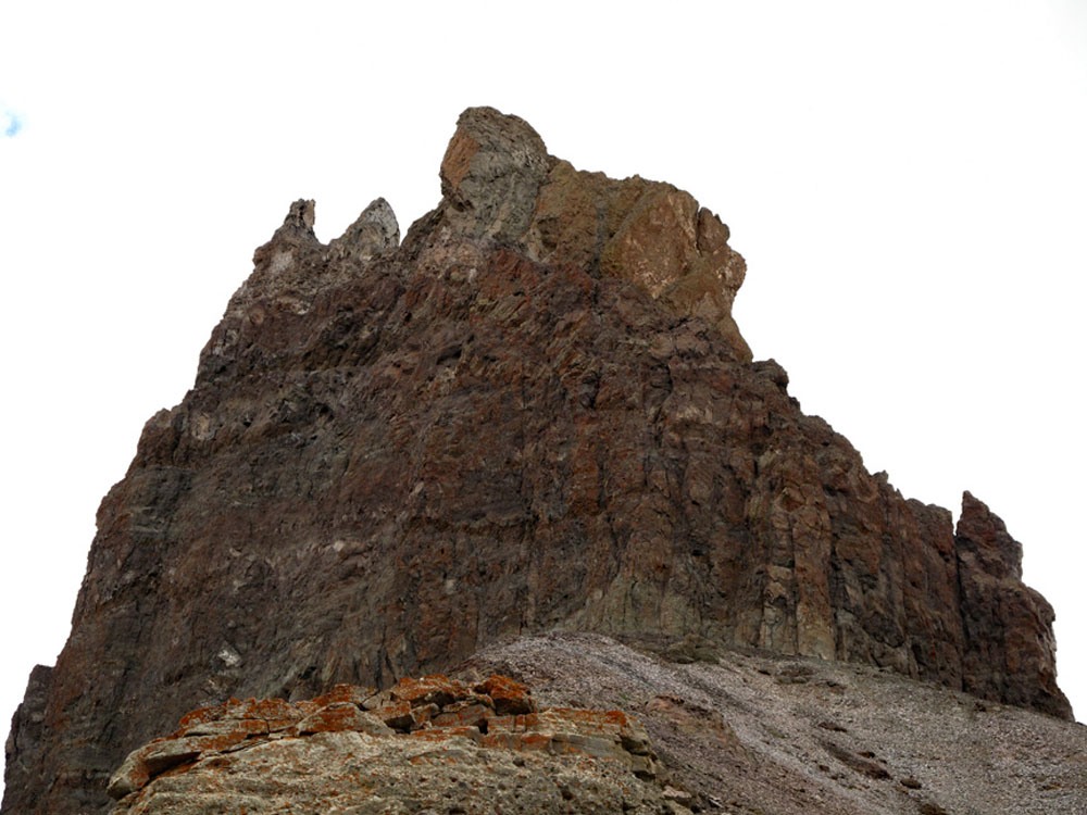
A few sticks of well placed dynamite could easily reduce this crumblimg mass to a rock pile not worthy of being included in the list of ranked 13ers. For years, we joked about doing just that so we would not have to climb it, but so far no one has made any such attempt, therefore, Lizard Head Peak remains as the most technically difficult 13er to ascend by it's easiest route and will likely continue to thwart some peakbaggers from the goal of ever climbing all the 13ers. This is NOT A WALK-UP! Lizard Head is rated a 5.7 or 5.8 technical climb and requires standard technical gear and expertise. The rotten rock enhances the danger of this climb substantially. Helmets are a critical piece of your equipment. The peak can be easily reached and climbed in a day and the trailhead is accessible to any passenger vehicle. If you don't possess the requisite skills to climb this peak, then go hire a guide (like we did) or walk away! Some indoor, rock-climbing gym practice or some real world experience climbing at a 5.8 level will greatly improve your chances of success. And, even with a guide, you must know proper rope handling techniques and be able to rappel. Our quote below by Mark Twain is pertinent to your decision whether or not to take on this challenge. Lidar removed one foot of elevation from this summit.
Lizard Head SW Chimney 5.8 Route
-
-
Cross Mtn. Trail - Lizard Head TH
The Cross Mountain Trailhead is located 2.2 miles south on State Highway 145 from the summit of Lizard Head Pass. If coming from Montrose, CO, drive south on US550 to Ridgway and turn west onto CO62. Drive west across Dallas Divide to the intersection with CO145. Drive SE 13 miles through Placerville and Sawpit to "Society Junction" where you will make a right turn to continue south on 145. (Going straight at this junction will take you into Telluride in 4 more miles.) Continue south on CO145 to the summit of Lizard Head Pass with stunning views of the summits around Trout Lake. Continue south another 2.2 miles to the trailhead parking on the right (west) side of the highway.
If coming from Durango, drive west out of town on US160. At Mancos, turn onto CO184 and head NW to Dolores. At Dolores, pick up CO145 and drive NE to the trailhead which will be 11.1 miles north from the center of Rico and on the west side of the highway.
Camping
The nearest Forest Servive CG is south of the trailhead on CO145 by 4.2 miles or about a little over 5 miles north of Rico. It's called the Cayton Campground. Here is the FS description: "Cayton Campground is 6 miles northeast of Rico on Colorado Highway 145 (part of the San Juan Skyway) 43 miles from Dolores. The entrance is 1/2 mile east of the highway on the Barlow Creek Road (Forest Rd. 578). The campground has 27 campsites, many along the river. Eighteen sites offer 50 amp RV electric plug ins. There are 16 reservable sites, 11 with electricity, and 11 non-reservable sites, 5 with electricity. Fishing is popular on summer weekends. At 9,400 feet, expect cool evenings. A dry dump station is in place."
North of Lizard Head Pass are the Matterhorn and Sunshine Campgrounds, closer to Telluride. The following are the FS description of each: "Matterhorn Campground is a highly developed campground adjacent to Colorado State Highway 145 near Telluride, CO. There are 28 campsites with 4 of them offering RV hookups (electricity and septic). Maximum spur length - 45 feet. Most sites on the outer side of the campground loop are wooded. Sites on the inside of the loop are more open. Most sites have pleasant views, especially the walk-in tent sites with unobstructed and panoramic views of the mountains. Showers are available to both overnight and day use guests. All sites have picnic tables, combination fire-rings and grills, and lantern poles. Firewood is available for a fee.
The campground is convenient to Telluride, CO with its' shops and a cook's night out. Hiking trails, fishing and jeep roads are found nearby. Lizard Head Wilderness is about 3 miles away."
Sunshine Campground is a single loop, paved campground with 15 campsites nestled in a dense aspen forest featuring a small mountain lake. Maximum spur length - 35 feet. A spectacular view of Sunshine Peak is visible from many sites. The campground is convenient to Telluride and its many shops and restaurants. No Reservations. First-Come, First-Serve Camping. $18 per night per camping unit; $4 per day for Day Use/Picnic in a campsite; $6 per firewood bundle; $5.00 per bag of trash (for non-registered guests); showers are available at the Matterhorn Campground for $6. Campers are required to store food and other items in a hard sided vehicle or camping unit constructed of solid non-pliable material. Click here for more information.
There also appears to be a fair amount of at-large camping at the summit of Lizard Head Pass. In general, the farther you get away from Telluride, the easier it is to find primitive sites.
Campsite Locations
Cayton › N 37° 46' 08.41", W 107° 59' 18.03"Elevation: 9,370 ft.
Click thumbnail to view full-size photo + captionRoute Description
Year Climbed: 2012There are a number of sources that can be consulted for routes on Lizard Head that likely provide better information regarding things like cam sizes, needed, etc. The following is simply our perspective, written by two people who never considered themselves to be "real" technical climbers.
Let the adventure begin! From the Cross Mountain TH, (#424 to #637 begin hiking across the meadows and head into the forest following the wide and very well-used trail. If you are climbing Lizard Head, you will likely be doing this in the dark, so headlamps will be useful as well as typical approach boots. The trail is never particularly steep. At a little over three miles, the Cross Mtn. trail intersects the Lizard Head trail #505 coming in from the east. Continue WNW to a pass between Lizard Head Peak and Cross Mountain. If heading up to Lizard Head, you may be able to cut up to the west ridge of Lizard Head before reaching the pass. If arriving in the early morning hours, you may have a very good chance of spotting some elk up here. Listen for them and be aware of their scent.
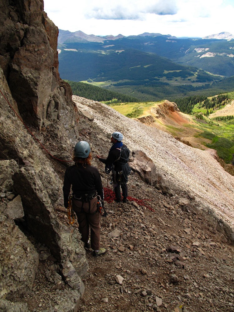
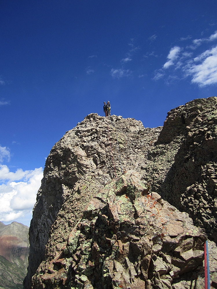
Once you gain the west ridge, follow a use trail as it zig zags up the mostly rocky slope with some tundra interspersed for a while. As you get higher toward the base of the summit tower, almost all vegetation will disappear. Once you reach the cliffs that form the rickety tower, follow at the base of the cliffs to the right (south) until you come to the prominent SW crack to begin the climb. Change into your climbing shoes here, harness up and set up your gear.
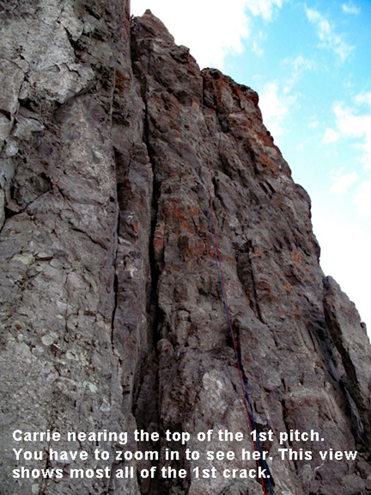
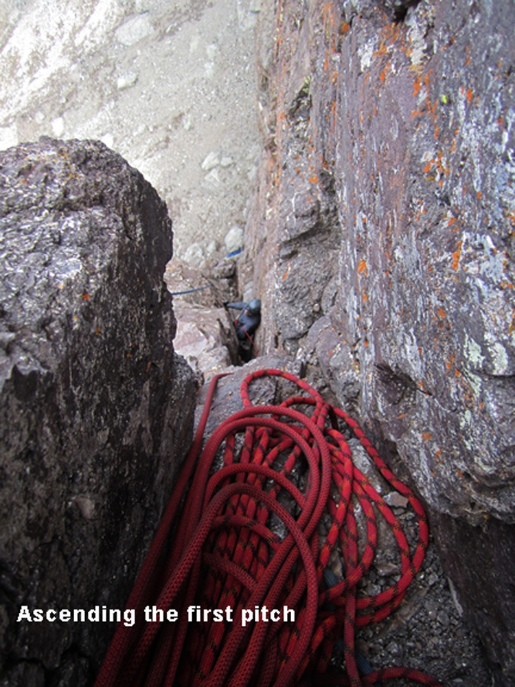
The first pitch is rated 5.7+. Some climbers split this into two leads, others one depending on factors like rope length, etc. The distance of this lead is about 155 ft. Some climbers choose to ascend directly up the crack, others begin by ascending the vertical wall just right of the crack for some distance before moving back over into the crack. Somewhere on this wall is an old piton that is still used as an anchor. We went up the wall before entering the crack. Once in the crack, having some skill in managing an off-width crack is useful. The upper crack is about body width. You need to know how to ascend in that situation. We found some of our canyoneering experience to be very useful here.
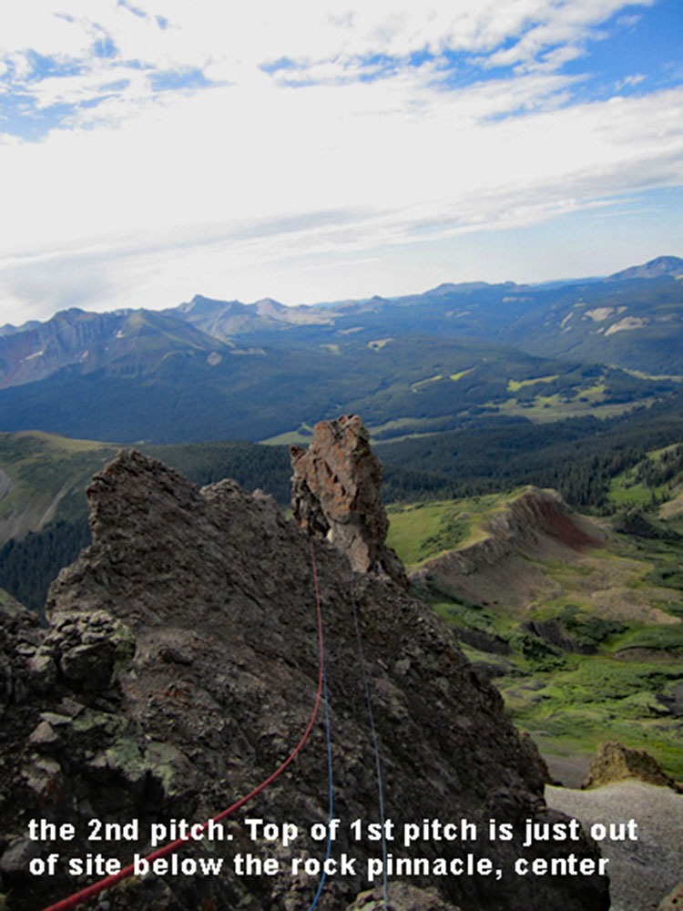
The first pitch crack ends at a notch that we referred to as a "crow's nest" because it felt like you were in a crow's next on a tall masted sailing ship. On either side it drops off precipitously. There is a large rock horn which everyone uses as a rappel anchor so there were multiple slings on it. There was barely enough room for three people in this notch. From the notch, the second pitch leads off to the north, more or less, and crosses in an upward contour across slopes covered in small scree that would rain down the cliffside. The traverse across this section, while not vertical by any means is made more precarious by the loose scree that covers most everything. There seems to be precious little solid rock to utilize, but fortunately, the going here is only about like a 3rd class scramble. With a good belay from our guide, we were able to move across this section quickly because there's really no climbing involved. To get out of the notch and onto the slope, there's a brief 4th class wall to go up, then you're on the scree slopes. Aim/angle to a crumbly rock overhang at the top of a steep scree slope. The second pitch will end here. Now you can rig up for the third.
Our guide used some features under this overhang to set up an anchor for the next lead using a couple of cams. We could belay from under the overhand and avoid some of the rock that might fall from above. As our guide was heading up setting the route, a near constant stream of small rocks were being rained down on us from above. The protection of the overhang was quite welcome. From the overhang, we climbed up to the left a little to reach the bottom of another crack. About ten feet up there was a "bulge" in the crack that presented something of a bulging overhang. Our guide set up extra protection here in case we needed it. Getting up and over that bulge is what gives this pitch the 5.8 rating. Once above it, we followed the mostly near vertical, body-width crack to it's terminus using technique similar to how we negotiated the crack on the first pitch. At this point we will note that strenuous rock climbing at 13,000 feet is an entirely different game. Combine the technical difficulty with the high altitude and you find yourself exhausted much more quickly. It took each of us about 20 minutes each to work our way up - in part because of a need to stop and catch our breath!
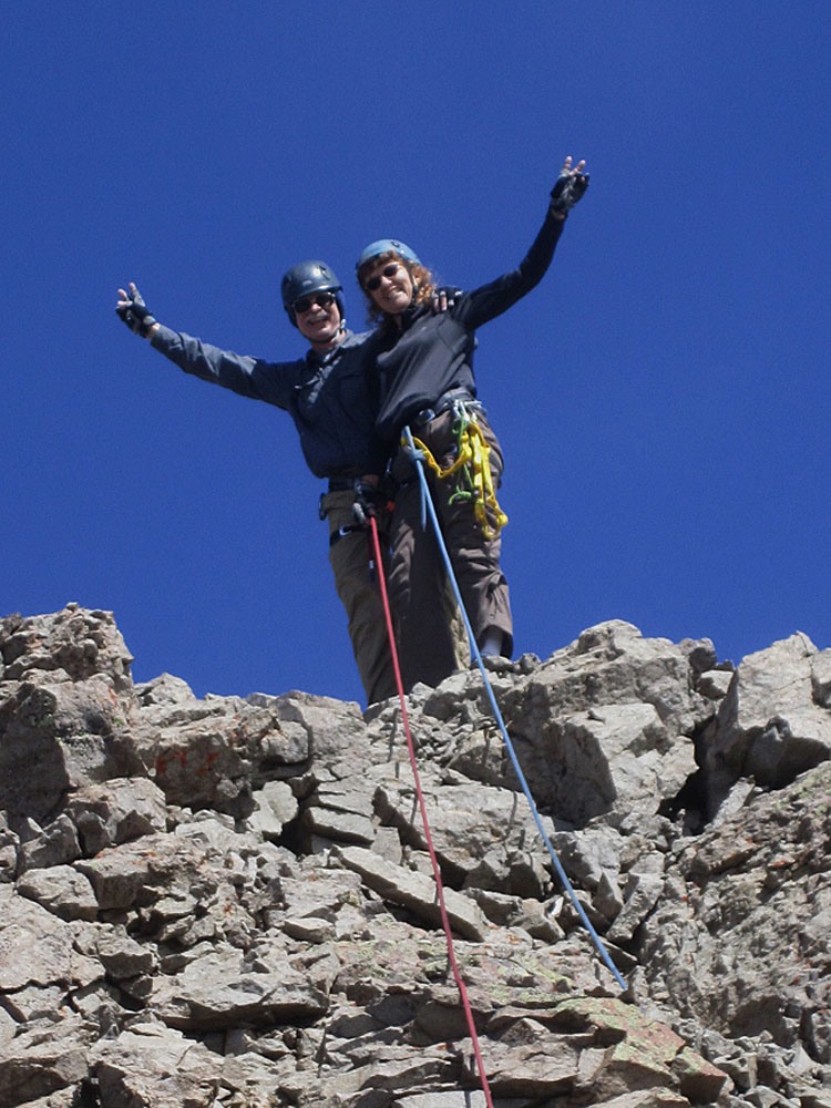
From the end of this pitch, which is in a fairly open spot, the remaining distance to the summit is no more than 3rd class and is basically a walk. Work your way over some rock outcrops, walk around the head of a vertical gully, then scramble on to the summit of more of the same loose, friable rock. With a 4:30 AM start, we arrived at the summit on a typically monsoonal day at 11:15AM. There was not much time to linger because we need to be off the technical portion before afternoon showers would hit and we anticipated they would begin early. This is such an exposed summit, you certainly do not want to be here with any lightening close by. A heavy piece of plumbing pipe held a register in 2012.
To descend, you will definitely need to rappel from the top of the third pitch. This is an airy and spectacular rappel. Enjoy it! Getting back across the second pitch will depend on your own ability to handle the scree-covered slope that could send one plummeting down the cliffs below. Many may want/require a guided set-up to get back down to the top of the first lead. We did not use one. For the final pitch, rappel is required again and it too offers a spectacular view of the terrain well below. You may see hikers down there pausing to watch you on your suicide mission.
Wrap-up: Now you may be asking yourself, "How do I stack up against these people?" So here's an attempt to help you answer the questions, "Can I do this?" and "What would be the best way to go about it?" We never have been what we would call "rock jocks." Though we had some rudimentary rock climbing skills, Tim has probably never led anything more difficult than a 5.6 and prior to this climb, neither of us had ever climbed anything more difficult than a 5.8 and that was in a slot canyon, which is a substantially different environment. Most of whatever skill we had was decades old and there was little by way of the other 13ers to prepare for this. So "how did we prepare?" Our main preparation came from our canyoneering experience. We definitely had rappelling under our belts as well as rope handling skills, knots and stemming skills. That all came in useful. Looking back on the experience, we would suggest anyone attempting this climb whose abilities are questionable should get a months membership in a local climbing gym and reach a point of proficiency where they can climb any of the 5.8 routes comfortably and at least some of the 5.9.
FYI: we contracted a guide through the Telluride Outdoor Adventure School. Our guides name was Keaton and he was a thoroughly prepared and skilled guide and instructor. He/they supplied all the necessary gear including helmets (which we already had), ropes, harware and rock climbing shoes. The service also included a nice trail lunch. We had previously filled him in on what skills and knowledge we had and the result was that Keaton did a great job of quickly assessing our skill level, did not overdo the safety protocols and allowed us to truly participate in the climb. We admit - he did all the leading. We just followed. Having invested about $500 in this guided adventure, we were prepared to make this summit "by hook or crook." Fortunately we did not need either. (We would have spent significantly more than that had we gone out and bought all of our own gear.) We had come prepared with ascenders if we reached a point where we thought we could not successfully free climb the route. We never used them and we never felt a need to have. In getting ourselves over the "bulge" at the third pitch, Keaton had placed an extra piece of webbing that we could use for a handhold if needed. That was the only assist we ever employed. The rappelling was easy and fun. So there you have it. You know how we did it. Now decide how you're going to conquer your own fears and stand on Colorado's most crumbling 13er summit. The links below should offer some additional help. Oh - and one other thing, we climbed Lizard Head at the end of a full week of peakbagging that included a backpack trip up Noname Creek and some moderately difficult summits in the La Platas. Also, we climbed Lizard Head the day after our 34th anniversary.
Additional BETA
Links to other information, routes & trip reports for this peak that may be helpful.SummitPost › Lizard Head Peak -