LoJ: #162 (Pre-LiDAR #171) / 13,672' Mount Mamma
Peak Summary
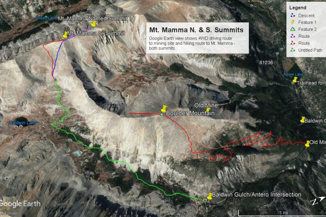
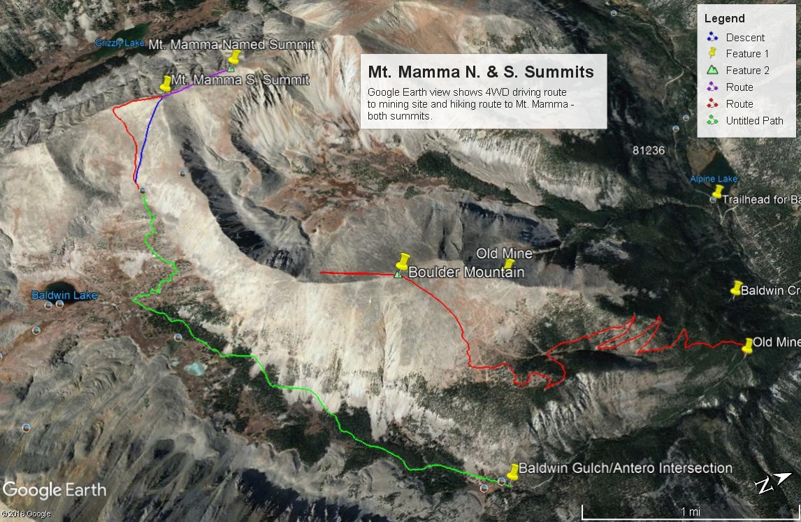
Mount Mamma is a Class 2 summit in the central Sawatch Range near St. Elmo. The mountain is best accessed with a stock 4WD/sport utility type vehicle and by driving up Baldwin Gulch. Shorter wheel-base 4WD can get you even closer. The peak has a named north summit which is lower than the south summit. Mount Mamma may be easily combined with Boulder Mountain, or with Grizzly Mountain by a longer ridge that goes at Class 2+. Lidar changed elevation from 13,646 ft. to 13,672 ft.
Mount Mamma South Ridge/Face Route
-
-
Baldwin Creek TH
From the center of town in Buena Vista at the US285 and CR306 intersection, drive south 8.1 miles south on US285 and turn right onto CR162. If coming from Johnson's Corner, drive south 5.7 miles to CR162. This is also known as "Chalk Creek Drive" and heads up towards the Mt. Princeton Hot Springs and takes you below the spectacular Mt. Princeton Chalk cliffs. Drive west on this road for 12.5 miles to the townsite of Alpine. Or measure from the end of the pavement 2.0 miles. Across from Alpine Reservoir is the turnoff for FR277 that heads up Baldwin Creek. There is very limited parking here. You may be able to find some parking around Alpine, but most everything is private property, so be careful where you park. Summer of 2019, we noticed a lot of vehicles parked along the road both before & after the trailhead.
It is possible to drive up the Baldwin Creek road if you have 4WD or 2WD with very good clearance. Every time we've been on this road (and that's quite a few), we have found it tediously rocky and slow and with more and more 4WD's, ATV's, etc., it is not likely to improve. We were last here summer of 2019 and took a quick look at the road condition. Personally - we would not advise going up this road any longer unless you have 4WD with excellent clearance. That said, we did notice signs indicating that some actual work (road repair) was going on, so perhaps there will be some improvements. This trailhead will be somewhat unique in having an "Upper Trailhead" as well. This is where FR277 and FR278 split with FR278 heading off to the left (SE) and immediately crossing Baldwin Creek. FR278 heads up onto Mt. Antero and eventually crosses over into Browns Creek. FR277 continues SW up along Baldwin Creek to a switchback where a trail to Baldwin Lake heads off. Trails Illustrated shows the road ending there now as does the Forest Service map. The coordinates for the FR277/FR278 intersection are N 38° 40' 57.11 W 106° 16' 22.56". Elevation there is 10,870 ft. The distance from the lower TH is 3.0 miles.
Camping
At-large camping opportunities along CR162 are very limited, mainly because of all the private property. There are National Forest, fee-based campgrounds along the way. They are: "Boot Leg" at 8,400ft. with 6 units & no water; Mt. Princeton at 8,000 ft. with 17 units; Chalk Lake at 8,700 ft. with 21 units and past the Baldwin Creek road and up toward St. Elmo, the Iron City CG at 9,900 ft. You can expect all of these to fill up on weekends. This road leading up to St. Elmo is a popular weekend destination for all types of recreationists.
Near the FR277/FR278 intersection, there are some limited, primitive camping opportunities. Drive just a short distance farther on FR277 toward Baldwin Lake and there is a good area with multiple campsites at the coordinates provided below. There are also some good primitive sites on FR278 just after crossing Baldwin Creek.
Campsite Locations
Baldwin Creek › N 38° 40' 50.08", W 106° 16' 29.15"Elevation 10,900 ft.Iron City › N 38° 42' 30.17", W 106° 20' 12.41"Elevation 9,900 ft. Turnoff is along the short stretch of road that leads down to St. Elmo. This campground has 15 sites, one vault toilet and an untreated water pump that we could not get to work.
Route Description
Year Climbed: 1988For the route trailhead, we are using the "upper trailhead" coordinates at the intersection of FR277 and FR278 along Baldwin Creek. Start walking from there along FR277 which continues up along Baldwin Creek, staying on the west side for the next 2.6 miles to a switchback at 12,000 ft. According to Trails Illustrated & the San Isabel NF map, the road ends here ( at least for vehicle access). An old track heads over to Baldwin lake from this switchback. For those with 4WD and good ground clearance, this 2.6 mile section may be driven, saving over 1,100 feet in elevation gain by foot. Along this 2.6 mile stretch, the road passes through a long stretch of talus followed by a much shorter section. This is where your vehicle will take the most abuse if attempting to drive.
From the switchback, the old roadbed continues to climb north on short switchbacks through scattered trees. At 12,250 ft. it will take a pronounced turn to the west and will terminate at an old mine site at 12,600 ft., just past the last trees. From the mine site, you can choose pretty much whatever path you want to follow. Basically, we headed for the saddle between Pt. 13,405 and Mt. Mamma's southern summit of 13,646 ft. The terrain has scattered, low tundra with plenty of rubble & talus to hike over. The gradient is not too steep so the rubble is not too loose. Once on the ridge, turn right and walk north along the ridge crest to the south summit, another 450 feet above the saddle. Once you obtain the south summit, it makes a certain amount of sense to go ahead and stroll on over to the named summit of 13,553 ft. There's less than 100 feet of elevation gain/loss to deal with. Round trip to this north summit and back to the south one will add 1.0 mile.
Mt. Mamma may be easily combined with Boulder Mountain by a long, connecting ridge that's just short of 2.0 miles long. We have not sequenced these two together however. So, for a descent, either return back down the ridge to the south and the saddle west of the mine or take a short cut route back, angling down the SE face toward the mine. The terrain is similar.
Additional BETA
Links to other information, routes & trip reports for this peak that may be helpful. -