LoJ: #256 (Pre-LiDAR #262) / 13,504' Mount Marcy
Range ›
Sangre de Cristo Range
Quadrangle ›
Electric Peak
Summit Location ›
 N 38° 08' 46.49", W 105° 40' 34.02"
(Not Field Checked)
N 38° 08' 46.49", W 105° 40' 34.02"
(Not Field Checked)
Neighboring Peaks ›
Electric Peak [Electric Peak A]
Gibbs Peak
Silver Peak [Formerly UN 13513]
"Cotton King Peak" [Previously UN 13490]
Peak Summary
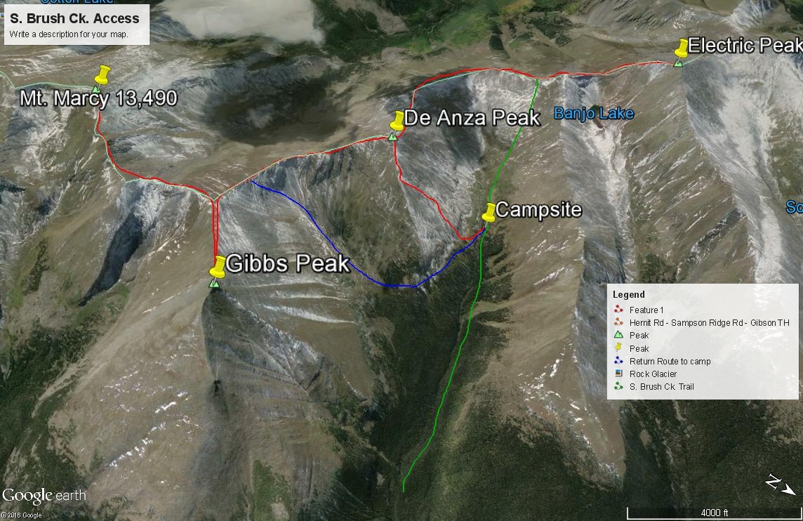
Mount Marcy is the final peak stop on our proposed four-summit day, but it doesn't have to end there. We hiked the ridge from Gibbs to Marcy and then returned to our camp in the upper part of South Brush Creek. But there are several other ways these peaks can be completed and several other peaks could be included such as Cotton King, Silver and Spread Eagle. See our separate write-ups for them. As for the Gibbs to Marcy hike, the 1.5 mile traverse is no more than Class 2 with one rockier section around Pt. 13,335. Use Gibbs Peak as the "access" for Marcy in this description. For trailhead access, on the east side of the range, use either the Ducket Creek TH or the Gibson Creek TH, both of which will utilize the Rainbow Trail to reach South Brush Creek. From the west side of the range, use the Cotton Creek TH. Lidar measurements have added 14 feet to this summit.
Mt. Marcy NE Ridge Route
Class 2
RT From Gibson Creek TH:
27.75 mi / 8,800'
RT From
with
"Electric Peak B"+"De Anza B"+Gibbs Peak:
8.25 mi / 4,300'
From Gibbs Peak:
1.50 mi / 600' (One-Way)
-
-
Gibson Creek TH
From the Town of Westcliffe: Alternate A: Drive north on HWY 69 and in about a mile, turn west onto CR170 (Hemenway Road) which will first head NW, then west. CR170 will take a brief jog to the north and then back to the west at CR175. Continue west and make another jog to the north at Pines Rd. then back to the west again. At a "Y" intersection, turn left onto CR171, (Ute Mesa Trail, but the Forest Service map seems to identify this as FR173. There should also be a Forest Service sign here for the Gibson TH.) driving through open fields and homes to CR172 (N. Taylor Road) where you will turn right (west), then head SW to the trailhead. The road officially ends in a short circle. A road continues on to private property. A trail heads north from this trailhead location to intersect the Rainbow trail (N38° 08' 28.87" W105° 36' 04.92"). There is private property all along this access. Please be respectful. At the bottom of all this description is a link to the San Isabel NF trailhead description for Lake of the Woods Trail and the Gibson Creek TH.
Alternate B: From the main intersection of Highways 69 and 96 in Westcliffe, drive south on 69 .3 mile and turn west (right) onto Hermit Road (CR160). Drive 5.9 miles west and then the road will turn north to intersect CR172. Hermit Road becomes Sampson Ridge Road as it switchbacks to make the connection, passing residences and ranches and working around "The Hogback." At CR172, turn left to finish the short drive to the TH. It's another 1.5 mile to the trailhead from the turn off Hermit Road. The last .2 mile on 172 may be rough and rutted according to one more recent source. Passenger cars may have some difficulty. If you're unable to park at the trailhead parking, park back along the road but be respectful of private property.
For another trailhead access to either South or North Brush Creeks, see the Ducket Creek TH, which is about 5 miles north on the Rainbow Trail of the S. Brush Creek trail and probably has less unnecessary elevation gain and loss. Look under our trailhead listing.
For an alternate access to the west side of the Sangre de Cristo Range and peaks in the same areas as Lake of the Clouds, try the "Cotton Creek" trailhead. Look for that name under the Trailhead listings. We have never used this trail, but it does show on the Rio Grande National Forest map and the Trails Illustrated Map # 138. The link below goes to the Rio Grande National Forest description of the trail:
http://www.fs.usda.gov/recarea/riogrande/recreation/hiking/recarea/?recid=29310&actid=50
Forest Service description of Lake of the Woods Trail and Gibson Creek TH: http://www.fs.usda.gov/recarea/psicc/recreation/recarea/?recid=12756&actid=104
Camping
Since there is so much private property along the access to the Gibson trailhead, we do not advise camping. Even at the TH, there is private property close by. You may be able to camp right at the TH but probably nowhere else on the way in.
-
From Gibson Creek TH via & Gibbs Peak:
-
Electric Peak A SSE Ridge Class 2 / 1.75 mi / 1,900’ One-Way
Open This Route in a New WindowFrom timberline and/or a high camp, continue hiking up the South Brush Creek trail to the central ridge at the trail crosses just above 12,800 ft. the trail works through mostly tundra with some rock. Turn north and hike over Pt. 13,060 and drop north to a saddle at 12,820 ft. Continue hiking NW to the easy summit of Electric Peak which has a nice view looking down onto Banjo Lake, nestled in a bowl a thousand feet below. This final section is still mostly tundra, embedded rock and some rubble. Since this part of the range is less frequented by human visitors, you may have some wildlife viewing opportunities including elk, bighorn or mountain goats.
For the return, retrace your route back to your S. Brush Creek campsite or continue hiking the central ridge south to De Anza Peak.
-
De Anza A NW Ridge Class 2 / 2 mi / 1,000’ One-Way
Open This Route in a New WindowFrom Electric Peak A, just head SE following the central ridge crest and always staying on the ridge. If there are any drop-offs to be concerned about, they will always be on the east side. The terrain is mostly tundra with embedded rock and some minor areas of boulder talus, scree, etc. For the most part it is very easy walking and mostly only Class 1 to low Class 2.
Alternate Route: From the suggested timberline campsite in the last trees, find a route across S. Brush Creek, then ascend the north flank of De Anza on mostly grassy slopes that will give way to more rock higher up. Once you gain the NE Ridge, walk SW to the summit on an easy tundra and rock mix.
For a return, go back as you came or continue on south along the central ridge to Gibbs Peak.
-
Gibbs Peak NW & SW Ridges Class 2 / 1.5 mi / 800’ One-Way
Open This Route in a New WindowWe climbed Gibbs as part of a day that included De Anza and Marcy, so we hiked to Gibbs from De Anza. The distance was about 1.5 miles on a typical Sangre de Cristo ridge connect - that is mostly easy tundra with embedded rock and a little rock rubble thrown in along the way. The summit block of Gibbs has some "blocky" rocks to hike/scramble over for the finish. The drop off on the east side of the ridge into Horseshoe Bend is rocky and fairly spectacular, but as long as you stay on the west side of the ridge crest, there's no danger or difficulty. You will lose over 600 feet in elevation and then have to regain about 800 to summit Gibbs. Once you enjoy the view from Gibbs, especially of the Wet Valley to the east, continue your march toward Mount Marcy.
If this is you last peak of the day, it is possible to exit out through Texas Creek. The San Isabel NF map does show a trail in that drainage that ends at some very small lakes/ponds/tarns in the upper north fork. Sketchy information about this trail and the brown shading used for it on the Trails Illustrated map would indicate this trail does not receive much use however. Attempt at your own risk and perhaps report what you find.
If you backpacked up S. Brush Creek as we did, then you can return to that timberline camp by walking WSW back along the summit ridge, heading NW back to the Gibbs-De Anza saddle and descending into the Horseshoe Bend drainage. From a little east of the Gibbs-De Anza saddle, head down an intermittent ramp of tundra and rock, cutting across three gullies before taking a more direct descent down into the drainage. To get back to our campsite, we contoured on the west side of the creek and headed for trees near Pt. 11,575. From there, game trails led us back to S. Brush Creek and the trail.
-
Route Description
Year Climbed: 1996From the summit of Gibbs peak, turn back to the SW and follow the ridge back to the main ridge that connects all these Sangre peaks and head south. Either skirt/contour around Pt.13,335 or go over the top and then continue SW to the summit of Marcy. The 1.5 mile traverse is mostly on tundra & tundra-embedded rock with no real difficulties other than a minor rocky section.
Once you've rested and enjoyed the summit view from Marcy, if you camped in South Brush Creek as we proposed, return along the ridge to the Gibbs-De Anza saddle and drop down into Horseshoe Bend as described with the Gibbs Peak route. For stronger peakbaggers who have no trouble carry backpacks at 13,000 feet, it would be possible to backpack this entire ridge section and include Silver Peak, Cotton King and Spread Eagle in your agenda before exiting either down to Cotton Lake on the west if you came in from the Cotton Creek TH or exit to Lakes of the Clouds and follow the Swift Creek trail back to the Rainbow Trail and return to either the Gibson Creek or Ducket Creek trailheads. As mentioned before, John Kirk reports on LoJ completing much of this section as a day hike. See his report.
-


Warning!
Climbing peaks can be dangerous! By using this site and the information contained herein, you're agreeing to use common sense, good judgement, and to not hold us liable nor sue us for any reason. Legal Notice & Terms of Use.