LoJ: #169 (Pre-LiDAR #167) / 13,657' Mount White

Peak Summary
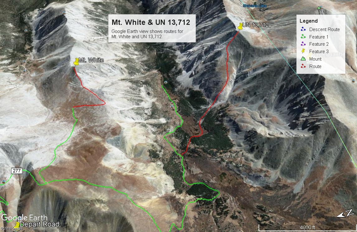
Mt. White is an easy Class 2 hike located just south of the 14er, Mt. Antero, and as a result is often overlooked and certainly dwarfed by its neighbor. The easiest/quickest access is the Baldwin Creek road FR277 near St. Elmo, but this access requires 4WD if you go beyond the FR277/FR278 intersection and drive up towards Mt. Antero. You can actually drive so high on Mt. Antero, that Mt. White can be ascended in about 15 minutes from a saddle between the two summits. Another access would be the Browns Creek Trail which would involve a number of miles hiking. To make this summit a little more sporting, hikers could park and walk from the FR277/FR278 intersection or drive up to about the 12,000 foot level on FR278 and park and walk from there, utilizing the remainder of the road up Mt. Antero. This report will only discuss the short section of the peak that requires walking from the Antero/White saddle. Before Lidar, this peak held an elevation of 13,667 ft.
Mt. White SW Ridge Route
-
-
Baldwin Creek TH
From the center of town in Buena Vista at the US285 and CR306 intersection, drive south 8.1 miles south on US285 and turn right onto CR162. If coming from Johnson's Corner, drive south 5.7 miles to CR162. This is also known as "Chalk Creek Drive" and heads up towards the Mt. Princeton Hot Springs and takes you below the spectacular Mt. Princeton Chalk cliffs. Drive west on this road for 12.5 miles to the townsite of Alpine. Or measure from the end of the pavement 2.0 miles. Across from Alpine Reservoir is the turnoff for FR277 that heads up Baldwin Creek. There is very limited parking here. You may be able to find some parking around Alpine, but most everything is private property, so be careful where you park. Summer of 2019, we noticed a lot of vehicles parked along the road both before & after the trailhead.
It is possible to drive up the Baldwin Creek road if you have 4WD or 2WD with very good clearance. Every time we've been on this road (and that's quite a few), we have found it tediously rocky and slow and with more and more 4WD's, ATV's, etc., it is not likely to improve. We were last here summer of 2019 and took a quick look at the road condition. Personally - we would not advise going up this road any longer unless you have 4WD with excellent clearance. That said, we did notice signs indicating that some actual work (road repair) was going on, so perhaps there will be some improvements. This trailhead will be somewhat unique in having an "Upper Trailhead" as well. This is where FR277 and FR278 split with FR278 heading off to the left (SE) and immediately crossing Baldwin Creek. FR278 heads up onto Mt. Antero and eventually crosses over into Browns Creek. FR277 continues SW up along Baldwin Creek to a switchback where a trail to Baldwin Lake heads off. Trails Illustrated shows the road ending there now as does the Forest Service map. The coordinates for the FR277/FR278 intersection are N 38° 40' 57.11 W 106° 16' 22.56". Elevation there is 10,870 ft. The distance from the lower TH is 3.0 miles.
Camping
At-large camping opportunities along CR162 are very limited, mainly because of all the private property. There are National Forest, fee-based campgrounds along the way. They are: "Boot Leg" at 8,400ft. with 6 units & no water; Mt. Princeton at 8,000 ft. with 17 units; Chalk Lake at 8,700 ft. with 21 units and past the Baldwin Creek road and up toward St. Elmo, the Iron City CG at 9,900 ft. You can expect all of these to fill up on weekends. This road leading up to St. Elmo is a popular weekend destination for all types of recreationists.
Near the FR277/FR278 intersection, there are some limited, primitive camping opportunities. Drive just a short distance farther on FR277 toward Baldwin Lake and there is a good area with multiple campsites at the coordinates provided below. There are also some good primitive sites on FR278 just after crossing Baldwin Creek.
Campsite Locations
Baldwin Creek › N 38° 40' 50.08", W 106° 16' 29.15"Elevation 10,900 ft.Iron City › N 38° 42' 30.17", W 106° 20' 12.41"Elevation 9,900 ft. Turnoff is along the short stretch of road that leads down to St. Elmo. This campground has 15 sites, one vault toilet and an untreated water pump that we could not get to work.
Click thumbnail to view full-size photo + captionRoute Description
Year Climbed: 1988The most difficult aspect of this route description will be the drive up FR278 on the west side of Mt. Antero. From the intersection of FR277 & FR278, head SSE on 278 continuing up through forest until you reach the last trees at just above 12,000 ft. The road turns east and heads briefly up a gully before making the first of six sharp switchbacks to gain elevation on the flank of Antero. After the sixth switchback, the road heads generally south and crosses a ridge at 13,100 ft. This switchback section of the road is the roughest and most tedious part of the drive (or hike). If hiking this section, attempts to shortcut the switchbacks will lead to frustrating loose rock conditions on a very steep mountainside.
At the ridge crossing at 13,100 ft., there is a fork in the road. Going left grants access to Antero and Mount White. Drive/walk a few hundred yards east, then take a right fork that drops from 13,100 feet to about 12,850 ft. This road forks cuts down across a tundra expanse. Part somewhere in the vicinity of the Antero/White saddle if driving.
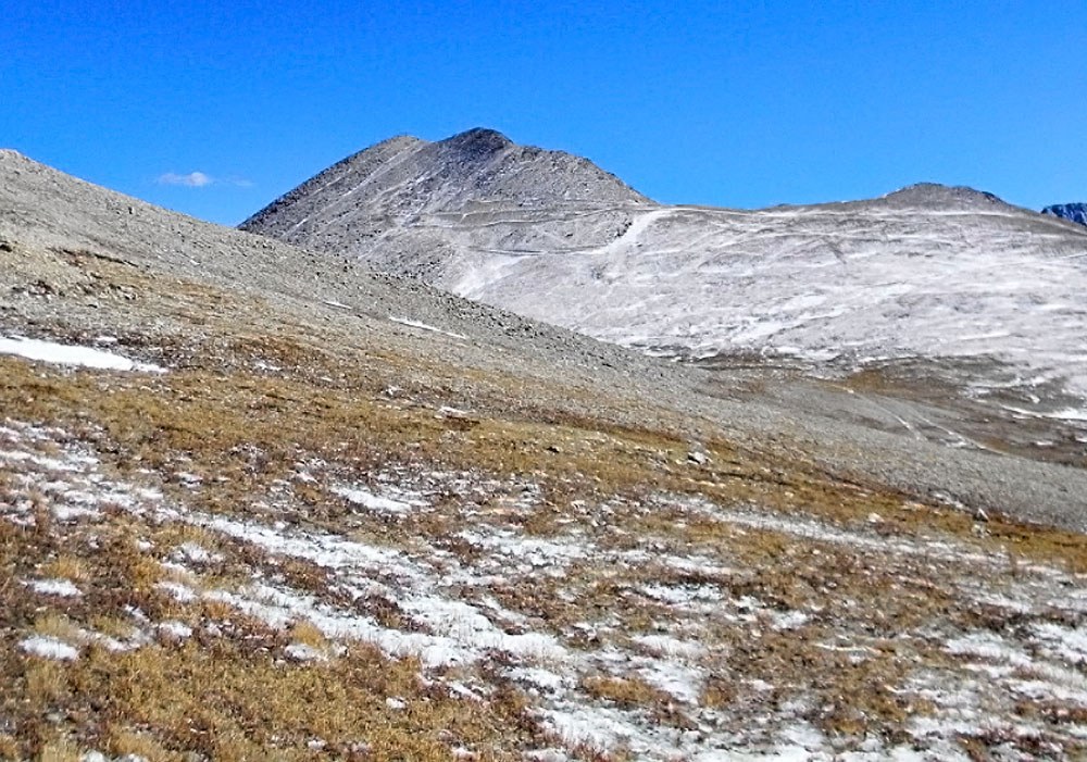
The trip up to White's summit is straightforward. There's an old mining road that heads SSW, gaining elevation across tundra to White's SW ridge. The same road switchbacks and follows the ridge east, but ends at some mining claims at 13,300 ft. Continue following the ridge east to the summit over the whitish rubble/talus and boulder rubble at times. You can also just skip the road and walk SE more directly to the SW ridge over tundra, embedded rock & scree. There are two apparent summits about 400 feet apart. As simple as this peak is, you might as well tag both just to make sure. On Google Earth we obtain a reading of 13,657 for the west summit and 13,664 for the east, but we do not find GE to be very accurate at all. The summit will afford nice views looking down into Browns Creek and across the valley to Shavano and Tabeguache.
If looking for a way to make Mt. White a more sporting ascent, it can be accessed from the Browns Creek trailhead, east of the summit by several miles. The round-trip hike will gain about 4,800 feet and total 13 - 14 miles in length. If hiking from a suggested vehicle park at 12,000 ft. on FR278, the one-way mileage will be 4.0 miles and 1,950 in elevation gain.
Additional BETA
Links to other information, routes & trip reports for this peak that may be helpful. -