#187 / 13,614' North Star Mountain
Peak Summary
North Star Mountain is a long, Class 2+ ridge walk with a lot of rock to navigate. Access is easy by way of passenger vehicle to Hoosier Pass. Reaching the true summit takes more work than the USGS map might suggest, but the reward is outstanding, high altitude scenery nestled between four 14ers.
North Star East/SE Ridge Route
-
-
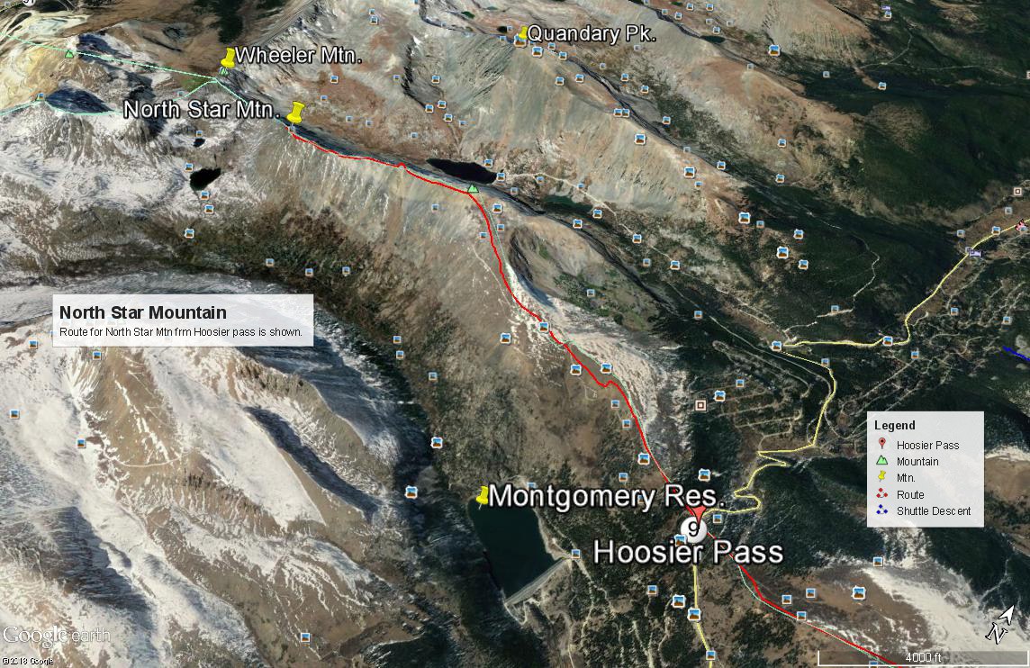
Hoosier Pass TH
The summit of Hoosier Pass is the trailhead for North Star Mountain, Hoosier Ridge and Red Mountain. The pass is located on State Highway 9. The trailhead for Mt. Silverheels is either 2.3 miles south of the pass on SH 9 or 2.85. There is a pullout on the east side of the highway at that location with a single-track road heading off up the hillside. A few yards north on the highway, there is a larger parking area on the west side. This is the second major drainage the highway crosses south of the Hoosier Pass summit. The small stream is unnamed on the USGS map. Roach refers to it as "South Scott Gulch." In case there is a mileage difference, the coordinates for the pullout are: N 39° 20' 05.16" W 106° 03' 04.23". Recent reports to us indicate that this old road access is now closed and marked for Private Property. If so, an alternate start is another .4 mile down from the pass towards Alma. See the Mt. Silverheels route description for further details regarding this alternate start.
From I-70, westbound or eastbound, take exit 203 or 201 for Frisco. From Frisco, continue southbound on SH 9 to Breckenridge. Continue on through Breckenridge past Goose Pasture Tarn and Blue River to the summit of Hoosier Pass where there is usually ample parking on the west side of the highway.
From the south, State Highway 9 can be picked up at Fairplay from US 285. Drive north on SH 9 through Fairplay, then Alma. (Watch for speed traps. The speed limits are rigidly enforced.) North of Alma, the highway begins its ascent to Hoosier Pass in earnest. The trailhead for Mt. Silverheels will come before arriving at the summit of Hoosier Pass. See coordinates above or see the Mt. Silverheels route description. For the other summits, accessed from the top of the pass, park just off the highway on the west side. In summer months there are usually numerous vehicles stopped here from out of state visitors taking in the view and gasping for air.
Camping
On the west side of the highway at the top of the pass there are several informal campsites (no facilities) that have evolved over the years. Enough for a half dozen campers or so. You'll just have to put up with some highway noise. Last time we used one of these sites was in 2013. This area has become well-known and typically full, especially on weekends. We would not be surprised to see the Forest Service or some other governing agency shut it down some day.
There are Forest Service, fee campgrounds in South Park, south and west of Fairplay. These are the Fourmile CG and the Horseshoe CG, both located on CR 18 that heads up toward Mt. Sherman. If you want camping information around the Dillon/Frisco area, see the link below. You can also find limited and not very private places to park and car camp on the north side of Hoosier Pass. Try CR850/Blue Lakes Road up to the lower lake or CR851/McCullough Gulch Road to the end of the road, past all the parking for Quandary Peak. Do not expect to find an available spot here on a summer weekend however, from all the climber traffic heading for Quandary. Otherwise, continued private development throughout this area has made at-large camping mostly a thing of the past.
Click thumbnail to view full-size photo + captionRoute Description
Year Climbed: 1988Note: Total round-trip elevation includes elevation gained by staying on the summit ridge.
From the parking lot on the west side of the summit of Hoosier Pass, proceed west on the non-maintained road that will climb just past the trees and a fork. You do not want the north fork. The left fork will work its way up the SE side of the mountain and come to a saddle just west of Pt. 12,214. If you do not want to walk the road (or driving may be possible in 4WD with good clearance), you can always just head straight up the SE ridge where you can find a trail to use. These coordinates are for where this trail intersects the road: N 39° 21' 40.39" W 106 04' 02.03". The trail is mostly on tundra/grass terrain with open forest to work up through, and will take you to the same saddle.At the saddle, heading west takes hikers across the mining claims for the Magnolia Mine and perhaps some other claims as well. It's best to leave the road here and adhere as best you can to the ridge crest to avoid the mine property as much as possible. There are No Trespassing signs posted along the road leading to the mine and it is our understanding that the mine is still somewhat active. We do not any incidences being reported of confrontations between owners and hikers, nor any indication of attempts to close this access, but be aware that this could all change. Please be respectful of all private property. Do not attempt to enter buildings or mine shafts, do not disturb any equipment and do not try to take any souvenirs.
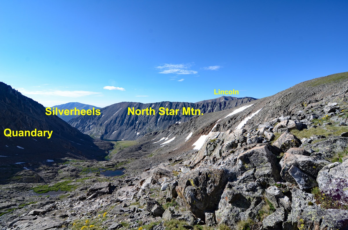
Heading NW up the ridge crest will still cross some 4WD roads. Just keep working up the ridge following either trail, which will skirt the first high point, or directly on the ridge to the same first high point at 13,460 ft. It's still mostly tundra to this point, but heading west along the ridge crest from here will see quite a change. From this point on, the ridge is moderately rugged with plenty of rock which will make for more work that you might anticipate just looking at any map, especially with a series of several closed contour lines indicating a number of small ups and downs. There are two false summits before reaching the true high point. That highest point is well west of where the USGS map places the peak name. The 2016 FSTopo map places the peak name even farther east. At times, the ridge crest narrows to just a few feet giving a sense of exposure. You're not really that likely to tumble to your death, however, winter conditions can make this exposure more challenging. Even in the earlier summer, there may be snow cornices to deal with.
There are two main ways you can tackle this long summit ridge: either try to stay on the crest all the way or hike down below the crest and do a lot of annoying side-hilling. Pick your poison. Either way, you will likely arrive at the summit later than you planned. This summit does not "feel" much like a summit. It's just the highest point on the otherwise, long ridge.
From the summit, enjoy excellent views of the 14ers, both north and south. On Quandary, you'll have a good view of the Cristo Couloir which drops down to the upper Blue Lake. Either return as you came or continue on to Wheeler Mtn. We have not done that traverse so we offer no information regarding it. North Star seems to be a popular winter ascent with several internet reports. One report on SummitPost should be read that records the ascent of a person who was literally picked up off the ground and thrown some distance by a powerful wind gust.
Additional BETA
Links to other information, routes & trip reports for this peak that may be helpful. -