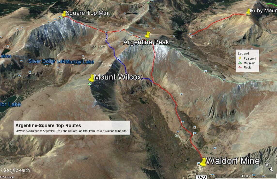
#111 / 13,799' Square Top Mountain
Peak Summary
Square Top Mountain is another easy, Front Range, Class 2 hike that offers expansive views. We have sequenced Square Top with Argentine Peak for a nice, half day hike. Though Square Top could be easily approached from the Naylor Lake road, the access to Square Top we suggest is the Leavenworth Creek road that leads up to the old Waldorf Mine and the east side of Argentine Pass. This is best driven in a vehicle with higher ground clearance, but 4WD is not required to make it to the mine site which serves as the trailhead. For those without such a vehicle, then see our write up on Mt. Wilcox and the Naylor Lake Road and Silver Dollar Trail.
Square Top NW Ridge Route
-
-
Leavenworth Ck - Waldorf TH
From I-70, take the Georgetown Exit 228 and drive east on 15th St. to a traffic circle. Proceed 1/4 of the way through the circle and exit south onto Argentine St. Drive south on Argentine then turn left onto 11th St. Turn right onto Rose St. and head south into the main part of town. Continue all the way to 2nd St. where you'll turn left and will be on SH 381. This is the Guanella Pass Road. Follow it south for 2.7 miles to the turnoff for the Leavenworth Creek Road #352 (aka: FS 248.1). The turnoff is at the sharp curve of a second sharp switchback south of the Georgetown Reservoir by about .7 mile. If you come to Green lake, you have gone too far. The elevation at this turnoff is 9,520 and coordinates are: N 39° 40' 59.55" W 105° 42' 09.83". The road will initially parallel above the highway, then make a sharp switchback to head up to a crossing of Leavenworth Creek. After that crossing, there will be three more sharp switchbacks before the road joins the old railroad bed and stays on it all the way back to Waldorf. The most difficult & rockiest part of this road occurs before joining the railroad grade. If you make it to that point in whatever vehicle you're driving, you can likely make it to Waldorf. 4WD is not necessary for a railroad grade road, but good clearance is helpful.
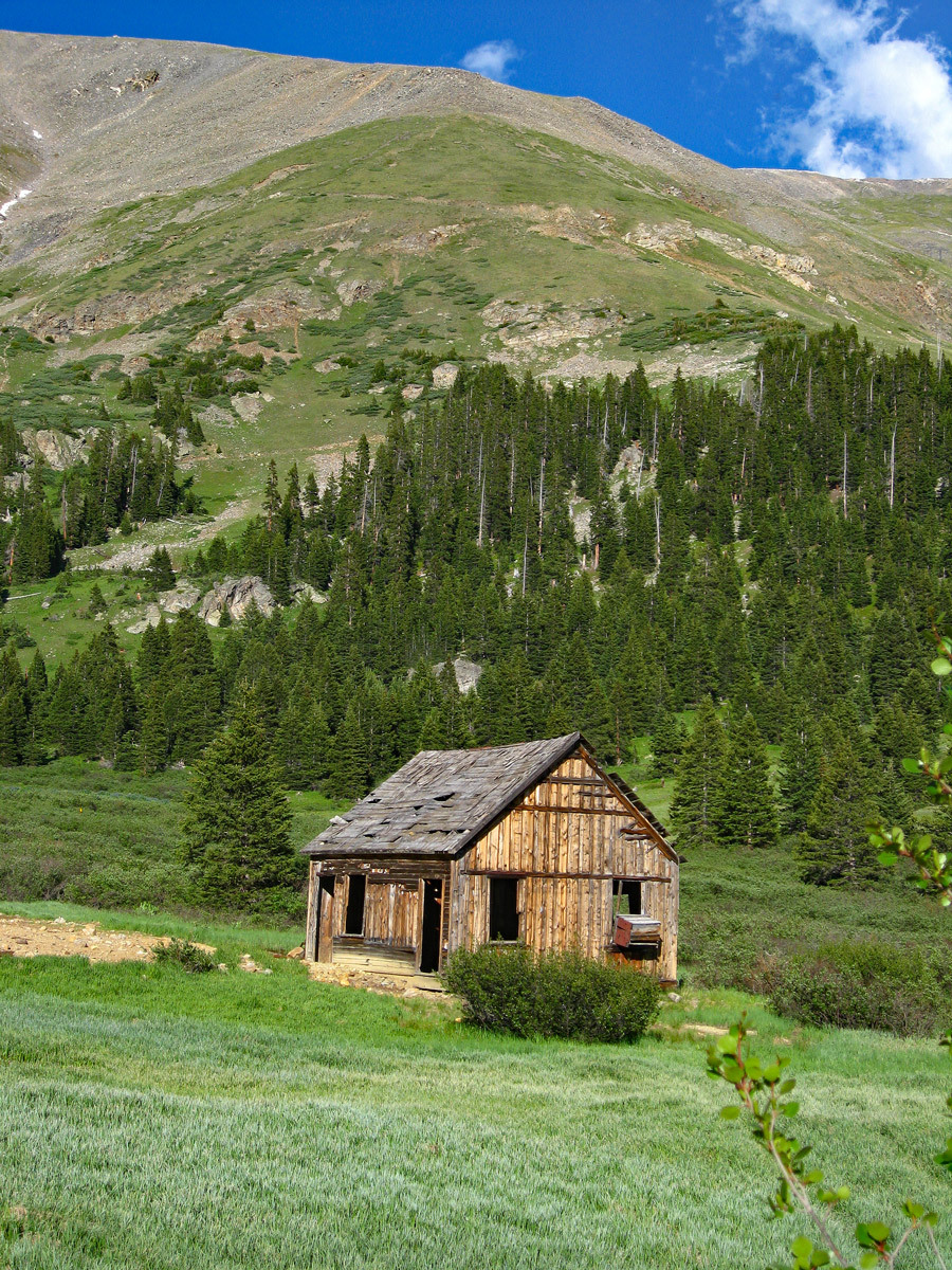
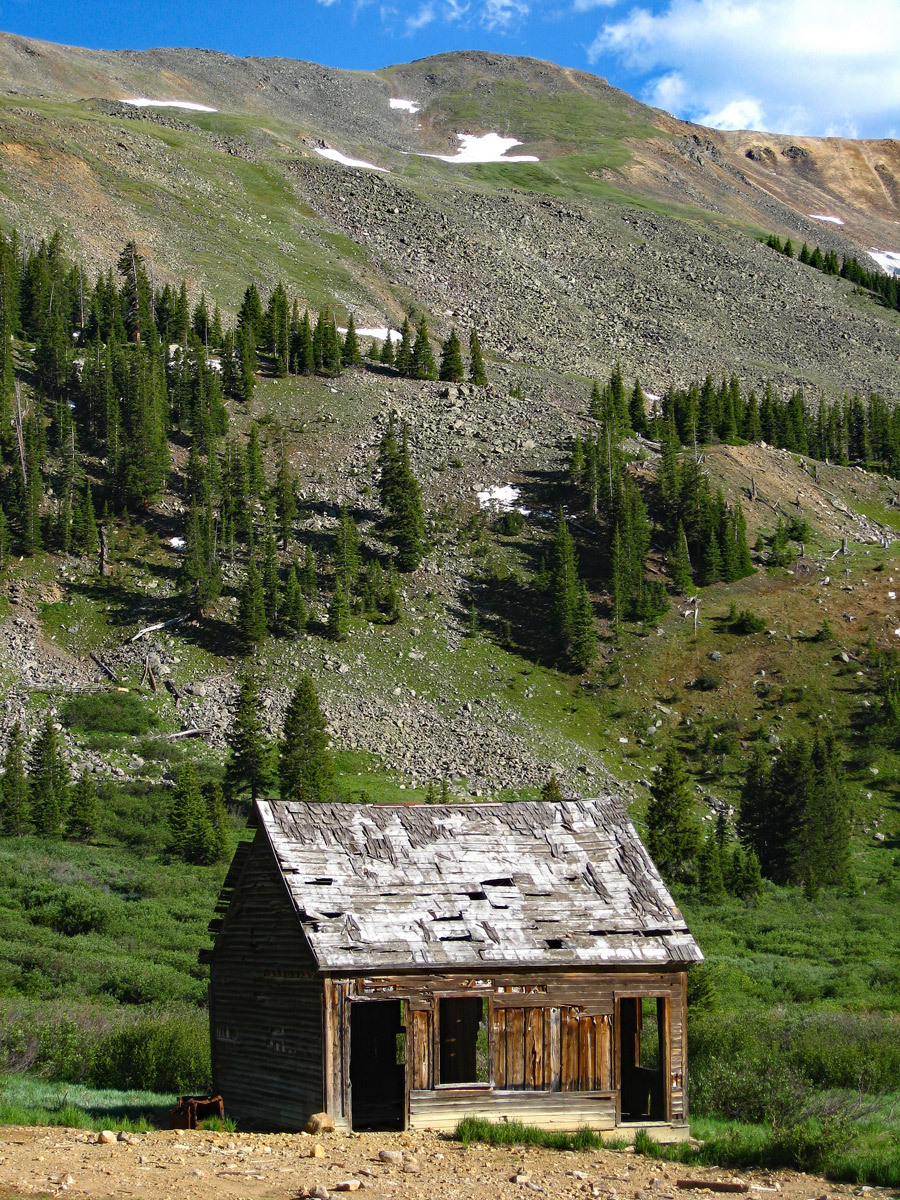
It's about 5.6 miles up the Leavenworth Creek Road to the old site of Waldorf. The road is dirt/gravel and is best driven in at least a higher clearance vehicle. This area is very popular for weekend visitors in ATV's and various 4WD vehicles. When we lived on the Front Range prior to 1990, visiting up Leavenworth Creek was one of our favorite places to go for a quick mountain getaway. As you head up this road toward Waldorf, there will be several at-large primitive campsites if needed, most of them located well up canyon, but expect most all to be occupied on summer weekends. Park at the old mill site at Waldorf at the coordinates provided above the map. Many vehicles will stop here during the course of the day, so if you would like to park your vehicle a little more out of the way, continue south up the road another half mile to a small pond where you can park at: N 39° 37' 59.26" W 105° 46' 11.15". (A report provided to us in 2020 indicated confusion with the roads beyond this point and difficulty in locating the "pond.") Beyond the Waldorf mine area, the road begins to deteriorate & become rockier. Parking at either of the two locations makes a good start location for Mt. Edwards, Wilcox, Square Top or Argentine.
The townsite of Waldorf was established in 1867, three years after a large silver vein/deposit was found in this area. John Edwards Wilcox, a Methodist minister, had much to do with the development of Waldorf. You can read more about the history of this area at: https://www.summitpost.org then search for Mount Wilcox under "Climbing, Hiking and Mountaineering."
Camping
The closest National Forest CG is further south on the Guanella Pass road. There are two: the Clear Lake and the Guanella Pass CG's. Otherwise, you can hope to get lucky and find a primitive site as you head up Leavenworth Creek. One of the best possibilities appears to be here: N 39° 38' 41.64" W 105° 45' 17.62".
-
From Argentine Peak
Click thumbnail to view full-size photo + caption
Open This Route in a New WindowFrom parking at the Waldorf Mine site head .3 mile to the crossing of the stream that drains the east side of Mt. Edwards. Cross on over and then take the right fork of the road which will climb up to the pond mentioned in the trailhead that offers another parking spot. (Most likely only 4WD with good clearance will access this spot.) The road makes a 90° left here and continues south up valley. Shortly, there will be a second fork. The right fork goes all the way up to the ridge that connects Mt. Edwards and Argentine Peak. This would be Argentine Pass. You could just walk this road all the way up to the ridge and then follow the ridge south to Argentine Pk. But on weekends, following the road will likely result in being continually passed by ATVers, etc., and eating their choking dust. So at this second fork, we suggest staying left and following the older, abandoned roadbed that continues toward the head of Leavenworth Creek. Where the road meets the NE ridge of Argentine Peak, depart the road and head up the ridge. A little ways up is a rocky section on the ridge crest that can be avoided by staying right of the crest. Most of the hike up is on tundra with embedded rock, some minor loose scree and occasional rubble. There's nothing difficult other than the angle of ascent is moderately steep.
From the summit, enjoy a nice panorama of the Front Range and of the view down into Peru Creek to the west. You will also be able to see the old road, now more trail, that was the west side of Argentine Pass. That stretch is now part of the Continental Divide trail. From the summit, return as you came; go back north along the ridge and hike down on the Argentine Pass road; or continue on the Square Top and/or Wilcox.
Click thumbnail to view full-size photo + captionRoute Description
Year Climbed: 1989Square Top Mountain is sequenced with Argentine Peak. One way mileage and elevation gain are measured from the summit of Argentine Peak. Please note that another way of completing Argentine, Square Top and Wilcox would be from the Naylor Lake road and the Silver Dollar Lake trail. See our write up for Mt. Wilcox to learn more.
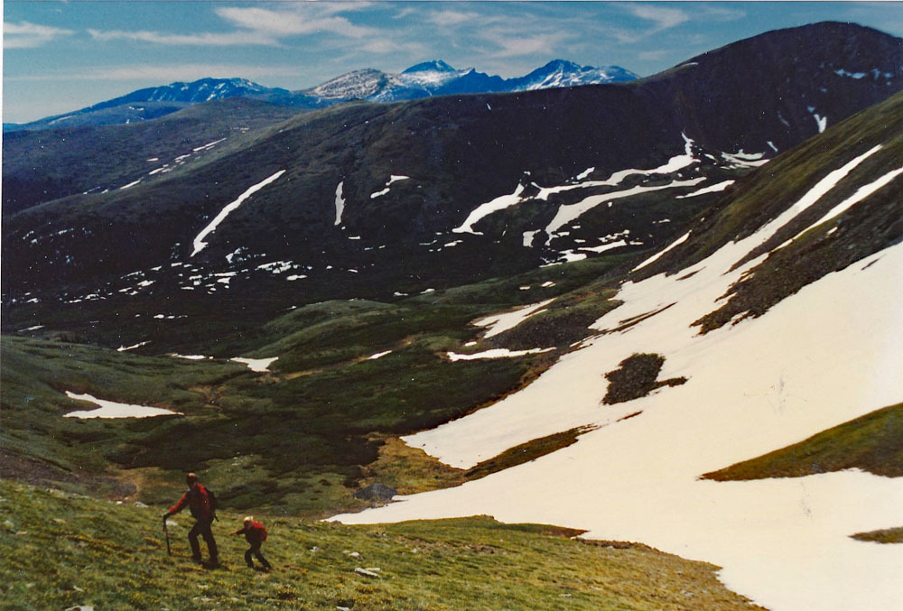
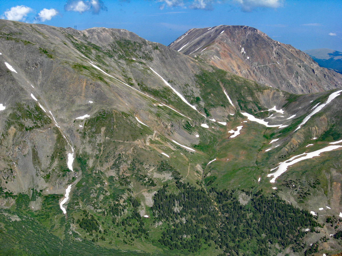
From the summit of Argentine Peak, head directly south down the ridge line for a half mile to where the ridge splits. Continue on the ridge that runs SSE, losing about 500 feet in elevation to the saddle. Continue SSE and begin ascending on the ridge line toward Square Top. Now you will need to regain nearly 800 feet in elevation to reach the summit. Most of this traverse will be on tundra, embedded rock, and some rubble or scree. The rockiest section will be the last few hundred feet approaching the summit of Square Top, then the summit ridge flattens out as its' name indicates. There are no significant difficulties. The summit of Square Top offers a nice panoramic view of the Mt. Evans massif as well as surrounding terrain. You'll be able to look straight down onto Silver Dollar Lake, Murray Lake and Naylor Lake.
Hiking in this area sometimes affords the opportunity to see some mountain goats. The goats on the Front range are much more accustomed to seeing humans and do not necessarily flee upon approach. When we did this hike with our children in 1989, we encountered a group of about 20 goats, mostly females and their less than a year old kids and perhaps some approaching their second year. Among those were some young males. It was interesting to observe their behavior as we walked right through their midst on the ridge. They had no intention of leaving that ridge for our sake, so we simply walked right through the group. One of the two year old males decided to challenge us. He would stomp and paw at the ground and wag his head back and forth, and even take a few steps toward us as a challenge, but would back off his threat if we simply spread our arms out and yelled at him a little. Twice he challenged us but each time backed away if we just held steady on our course and not let him intimidate us. Now would we try the same approach with a full grown male? No sir, and you should probably not either.
For the return trip, head back down the same ridge you came up and back to the saddle at 13,000 ft., west of Silver Dollar Lake and the higher Murray Lake. From the north end of the saddle, at about 13,000 ft., contour north around to the SE and east slopes of Argentine Peak and thread a route past the remnants of an unnamed pond above Murray Lake, where there's more vegetation, staying as best you can at or near the same elevation. Continue to contour until you reach the east-west ridge that connects Argentine and WIlcox. At this point, make a decision as to whether or not to include Wilcox. If you do it will add another 1.8 miles to your day and an additional 550 feet of elevation gain. When finished with Wilcox, return to the same place as where you intersected the connecting ridge. Look north into the Leavenworth valley below and identify the old roadbed that ends near one of the power line structures at about 12,260 ft. On the ridge where you stand, there is a power line support structure. Just a little east of that structure there use to be a faint trail that drops down north through the steep valley headwall. Coordinates for the old trail are: N 39° 36' 39.34" W 105° 46' 05.35". Drop on down that trail for 300 feet, then head out on the tundra toward the next power line structure. From that structure, head downhill more in the direction of the next structure, but before arriving at it, watch for an opportunity to skirt below some rocky outcrops and above some willows to intersect the old roadbed you observed from up on the ridge. Once on the road, follow it all the way back to the Waldorf Mine where you parked (or the other location past the mine if you used 4WD). The advantage of this route is you can avoid any entanglement with the willows that choke the lower Leavenworth valley. The trail mentioned above may now be unidentifiable. In that case, just use the view you have of the terrain and the utility lines to guide you back.
Additional BETA
Links to other information, routes & trip reports for this peak that may be helpful. -