LoJ: #246 (Pre-LiDAR #250) / 13,514' Bridal Peak Formerly T11
Peak Summary
As part of a traverse from Three Needles, Bridal Peak, (T.11) is not quite as difficult as it appears, but still involves a sketchy scree descent into the upper portion of the East Basin above Bridal Veil lake before reaching easier terrain and the final hike to the summit. Class 2+
Formerly known as T11, this summit has recently been given the official name of "Bridal Peak," assigned by the USGS. The following links will shed some more light on this name change for those who would like to know more:
http://www.telluridenews.com/the_watch/news/article_5f4ff46d-3bf6-5b48-b3dd-861ce2a6ac30.html
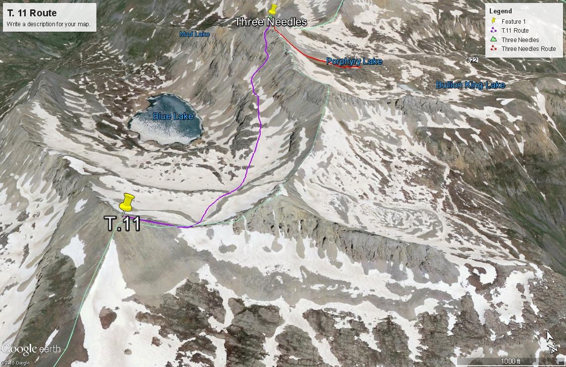
Bridal Peak East Saddle & Ridge Route
-
-
Red Mountain Pass - Black Bear Pass Access TH
We're writing this trip up with the assumption that climbers do not have a 4WD vehicle available, hence, the trailhead for this peak, Trico Peak, T.10, Three Needles, T.11 and UN13,159 is just south of the Red Mountain Pass summit. From Ouray, drive south on US 550 to the summit of Red Mountain Pass and park just south of the actual summit on the west side of the road where the Black Bear Pass road takes out. (FR823) From Ouray, this will take about 20 - 25 minutes of driving.
From Durango, drive north on US 550 to the Red Mountain Pass summit. Park on the west side of the highway just south of the summit where the Black Bear Pass road begins. (FR823)
If you have 4WD with good clearance, you may drive to the summit of Black Bear Pass and reduce both the mileage and elevation gain for the day considerably, if climbing UN13,510, Trico or T.10. In 1996, we found the road up to the pass surprisingly good with no real clearance problems. It was just steep in spots. The more rugged and notorious sections of the Black Bear Pass road are apparently further down on the Telluride side. However, our son reports from trips in 2012 - 2014 that the switchback at about the 11,700 ft. level is deteriorating and becoming progressively more difficult to navigate due to increased use and no maintenance.
Camping
While there are no designated Forest Service campgrounds in the immediate vicinity, north or south of Red Mountain Pass, there are numerous at-large, primitive sites close by. One is located on a knoll, by driving up the Black Bear Pass road about 1 mile and taking a left fork of the road that leads over to Porphyry Basin. Drive up to the knoll no more than .3 mile from the intersection. The elevation is appx. 11,600 ft.
Another good primitive camp location(s) if coming from Ouray is located at the south end of Ironton Park on the east side of the highway, in the vicinity of the road for Corkscrew Pass. If coming from Durango/Silverton, your best bet will be up the South Mineral Creek road.
Route Description
Year Climbed: 1996Note: We climbed Bridal Peak (T.11) on a day that included Three Needles first, Bridal next, then was followed by UN13,159. The total miles and elevation gain provided reflect climbing all three peaks. The actual distance from Three Needles to Bridal is about 1.25 miles with 800 feet of additional gain. This route description begins from the summit of Three Needles.
From the summit of Three Needles, head back down the west side of the south ridge per our description for Three Needles, and return to the notch that allowed access to the south ridge from Porphyry Lake and Basin. If you attempt to proceed further along the ridge crest, there will be a difficult notch followed by a traverse of spires and other obstacles all the way to Pt.13,375. "Furthermore" on LoJ, describes descending on the east side of the ridge to drop below the rough section, then regaining the ridge beyond Pt.13,375 to continue on to Bridal.
As for us, from the notch where we first gained the south ridge, we began dropping straight to the west, following down one shallow gully until we were forced further south to seek a route through a sloping cliff band. We located a place to cut through the cliff and as it turned out, this may have been the only safe place for some distance. Once through the cliff band, it was still more descending for several hundred feet to a rocky bench area at about 12,700 ft. All of this descending was on very steep and extremely loose and treacherous talus. Elevation loss was at least 600 feet.
Once on the bench, head south over large boulders that will give way to tundra. In earlier season, there may be some snow to negotiate. Cross the easy East Basin bench and begin your ascent to the low point of the connecting ridge between Bridal and Pt.13,434 to the east. There will be one steeper ascent place at about 12,800 ft. Stroll across another higher bench and make the final short climb to the east ridge. The section of ridge from the low point to the east will have some spectacular gendarmes, but heading west, you'll encounter no difficulties other than the boulders you'll have to scramble over. Once on the summit, make your decision as to whether or not to include UN13,159 in your day or begin your return hike to Red Mountain Pass or wherever you left your vehicle.
If returning from Bridal Peak to the start, we suggest heading down the south ridge of Bridal, and then dropping down some into the vast Mill Creek Basin. Contour east around Pt.13,228 and north into another basin below Pt.13,375. Contour yet again, at about 12,600 - 800 feet to the east around another protruding ridge and back into Porphyry Basin where you can rejoin your access route from the morning. This is all just Class 2 hiking over varied terrain that includes one rock glacier to cross, some splendid wildflowers and tundra.
-