LoJ: #264 (Pre-LiDAR #266) / 13,494' Three Needles
Peak Summary
Upon first view, Three Needles may cause a little angst and make you wonder if you should have brought a rope and gear, but the impressive summit complex gives way to no more than some entertaining, 3rd class scrambling. 4WD helpful for accessing but can be easily done as a day hike. Combines well with either T.11 or T.10. Lidar added 13 feet of elevation.
Three Needles E Face/S Ridge Route
-
-
Red Mountain Pass - Black Bear Pass Access TH
We're writing this trip up with the assumption that climbers do not have a 4WD vehicle available, hence, the trailhead for this peak, Trico Peak, T.10, Three Needles, T.11 and UN13,159 is just south of the Red Mountain Pass summit. From Ouray, drive south on US 550 to the summit of Red Mountain Pass and park just south of the actual summit on the west side of the road where the Black Bear Pass road takes out. (FR823) From Ouray, this will take about 20 - 25 minutes of driving.
From Durango, drive north on US 550 to the Red Mountain Pass summit. Park on the west side of the highway just south of the summit where the Black Bear Pass road begins. (FR823)
If you have 4WD with good clearance, you may drive to the summit of Black Bear Pass and reduce both the mileage and elevation gain for the day considerably, if climbing UN13,510, Trico or T.10. In 1996, we found the road up to the pass surprisingly good with no real clearance problems. It was just steep in spots. The more rugged and notorious sections of the Black Bear Pass road are apparently further down on the Telluride side. However, our son reports from trips in 2012 - 2014 that the switchback at about the 11,700 ft. level is deteriorating and becoming progressively more difficult to navigate due to increased use and no maintenance.
Camping
While there are no designated Forest Service campgrounds in the immediate vicinity, north or south of Red Mountain Pass, there are numerous at-large, primitive sites close by. One is located on a knoll, by driving up the Black Bear Pass road about 1 mile and taking a left fork of the road that leads over to Porphyry Basin. Drive up to the knoll no more than .3 mile from the intersection. The elevation is appx. 11,600 ft.
Another good primitive camp location(s) if coming from Ouray is located at the south end of Ironton Park on the east side of the highway, in the vicinity of the road for Corkscrew Pass. If coming from Durango/Silverton, your best bet will be up the South Mineral Creek road.
Click thumbnail to view full-size photo + captionRoute Description
Year Climbed: 1996As with UN13,510, Trico, and T.10, we're assuming you do not have a 4WD available, so the mileage and elevation estimates are based on starting out on foot from the parking area described just south of the summit of Red Mountain Pass. From that location, head up along the Black Bear Pass road (FR823) for about one mile to an intersection where you turn left (south) and proceed up to a knoll with some trees and a good camp spot. Shortly beyond that knoll, the 4WD road heads up a very steep section. Over the years that section has deteriorated and become very loose and difficult. If you're attempting to drive this, experienced drivers might be able to make it up, but if you lack experience, you may want to park back at the knoll. Recent reports we have received indicate that the remaining road into Porphyry Basin has several other impassable spots on it anyhow and you may not make it that much further. You may want to check this website for better, more recent reports: Click here.
Porphyry Basin can also be accessed from FR822 which begins less than one mile south from the summit of Red Mountain Pass. Going in this way will avoid the one steep, loose section mentioned before, but the two roads join up at the switchback at about 11,750 ft. Beyond there, are the additional road sections where collapse of the road has made vehicle passage impossible unless there has been recent restoration.
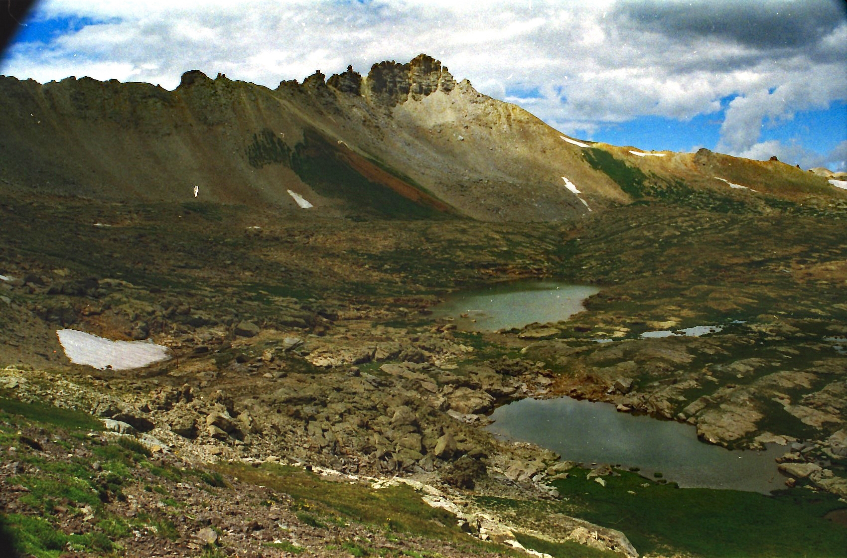
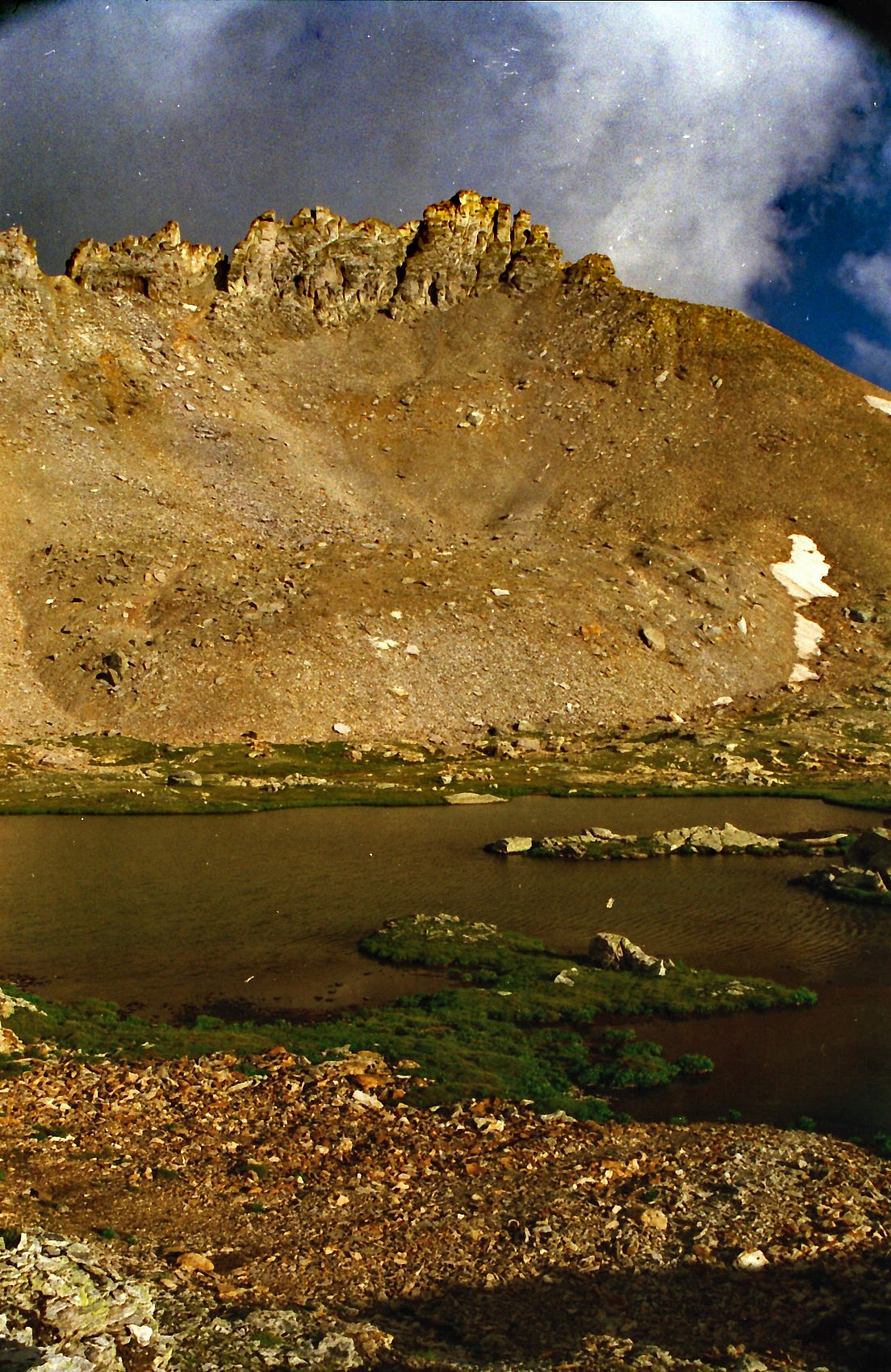
Whether on foot or vehicle, continue following FR822 up into Porphyry Basin. The old road use to end at 12,400 anyhow, so you will definitely be on foot after that. Follow the old road bed up to Bullion King Lake and walk by the lake on the NE side. The northern and western edge of this lake is bordered by a nice cliff with a waterfall plummeting through a narrow slot from above to the lake. From the lake, head west across the tundra examining your route possibilities on Three Needles, now clearly in view. At Porphyry Lake, stop long enough to make your final decision. As you look at the summit block, which appears to be a well-guarded rock fortress with limited access points, there will be a very steep couloir just left of the summit block that appears to go at a 4th class level. We chose not to take that route. Instead, further to the left along the ridge, there is a rocky slope that leads up to another narrowing couloir that ends on the south ridge at a prominent notch.
Climb up the unstable, steep and loose rocky slope to the notch. If in a party of 3 or more, helmets are advisable. Spread out to avoid putting rocks down on each other. At the notch, we found a cairn-marked route that led over easy 3rd class scrambling to the true summit. If no cairns are to be found, traverse along the west side of the ridge to the main summit block. Climb up through some minor cliff bands on rock covered with gravel pellets. Scramble over some more loose rock and then gain the small summit. One of the other "Three Needles" should be directly west of you just a short distance if you have reached the highest needle. This other "needle" would be a technical climb.
Note: If connecting T.10 with Three Needles, on LoJ, "Furthermore" describes following the ridge from T.10 over to Three Needles. His route skirts the main summit block on the east side and appears to gain the south summit ridge much as we have described here.
Admire the view of Blue Lake far below in the east fork of Bridal Veil Basin. Return by the same route or continue on to T.11, a little over one mile SSW.
-