#236 / 13,535' Treasure Mountain
Peak Summary
A class 2+ hike in a fairly remote area that provides an opportunity to overlook the Ruby Range. Combines easily with Treasury Mountain. 4WD or high clearance vehicle will be required to reach the trailhead in the small mountain village of Crystal. Lidar measurements added 7 feet.
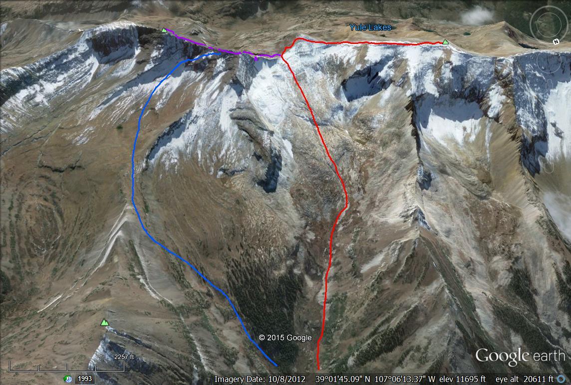
Treasure Mtn. Bear Basin Approach Route
-
-
Crystal Townsite TH
From HWY 82 and Carbondale: Turn south off HWY 82 and drive into Carbondale staying on the main road, which is State Highway 133. Drive south past Redstone and on to the turnoff for Marble, which is less than a mile before where the highway begins to make the climb up to McClure Pass at a definite switchback. Continue on rougher pavement to the town of Marble. Make a couple of left-right jogs to continue east to Beaver Lake. If in a passenger vehicle, you might as well park here. If you have 4WD, continue east past Beaver Lake and up a steep climb to the intersection of Roads 315 and 314. Take 314 to the right for Crystal. The narrow, one-lane road drops to a shelf section where visibility of other vehicles approaching from the opposite direction is limited. Try honking your horn to alert others to your presence. You'll climb back up a little after the shelf section then eventually drop down to creek level. It's a slow and rough 4 miles to the Crystal townsite. Park where you won't interfere with the private residences. It may be both polite and advisable to request permission to park.
Camping
There is no camping in Crystal, or at least, we would assume the residents there don't want people camping in their front yards. On the 4 mile drive in, there are a few at-large spots right alongside the road. There are three National Forest fee campgrounds back out on HWY 133. One is at Redstone, the other just after turning off 133 for Marble and the third just over the top of McClure Pass.
Click thumbnail to view full-size photo + captionRoute Description
Year Climbed: 1998Note: This route description is the first segment of a day that also includes Treasury Mountain. The overall mileage and elevation gain estimates reflects that inclusion.
The most significant difficulty of this hike may be finding a way across the Crystal River from the town. In 1998, we inquired with a local resident who told us to walk east past the last cabin and turn south to cross the creek. She mentioned a former bridge that was no longer there. A trail led down to the water and we found the river divided into 3 separate channels, separated by willow-covered islands. The third channel posed the greatest difficulty but we managed to get across dry on an unsteady, fallen tree and some rocks. The 9th edition of the "Guide To the Colorado Mountains" makes mention of a book by John Beyer, "Hikes and Climbs from Crystal," that describes crossing either on "an Outward Bound suspension bridge or on logs behind the southernmost house." Take that beta for what it's worth. Once you find a way across, head south up a steep embankment to an old roadbed and follow this east until it disappears. Continue bushwhacking through logs and underbrush, climbing up a steep slope to locate a vague trail on the west side of the creek that drains Bear Basin.
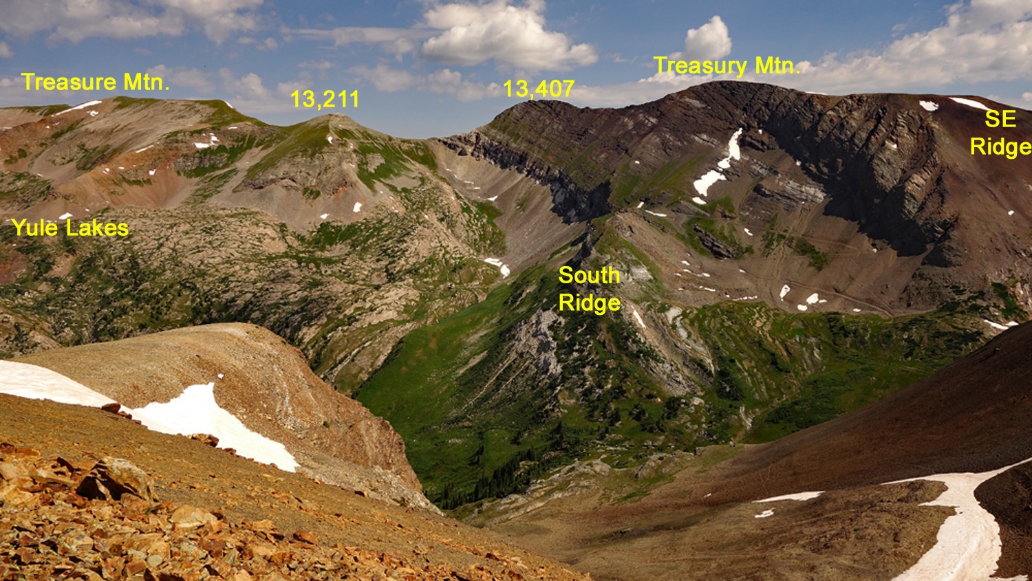
Most of the hike up along the creek is out of the forest, however that does not make the going any easier. The open field you initially encounter will be covered in a lush undergrowth and whatever trail you find will likely become lost in that vegetation. (Perhaps now, 17 years after recording this trip, a better trail has evolved.) Higher up, you may be able to regain the trail if you've lost it, once you clear the dense growth. Prepare to be soaked if it's rained recently. The lush vegetation continues quite a long ways into the upper basin. Above 10,300 feet, follow the west fork and further up, the tall vegetation gives way to lower growing tundra. Streams of water will be cascading across giant slabs of rock and the "Chimneys of Treasure Mountain" will loom dramatically to the west. At 11,800 feet, turn directly south and head towards the saddle just west of Pt.13,407. In early season, expect snowfields up to the saddle. Ice axe will be useful and/or microspikes. In later season, expect rocky rubble. The saddle is not difficult to gain.
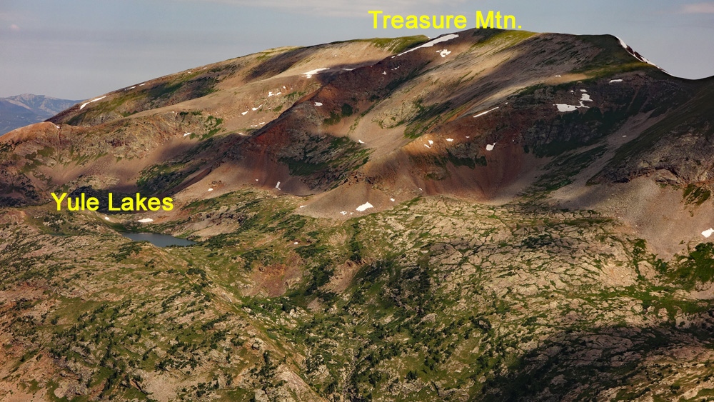
At the saddle, turn west and follow the long ridge crest, first hiking over Pt.13,211, then losing about 100 feet and then continuing on mostly tundra with minimal rock to the summit. From this summit, you'll enjoy a spectacular view of the Snowmass massif to the north and the Ruby Range to the south with Yule Lakes sitting at the southern foot of Treasure Mtn.
Additional BETA
Links to other information, routes & trip reports for this peak that may be helpful. -