LoJ: #302 (Pre-LiDAR #300) / 13,437' "Sundog" Formerly UN 13432
Peak Summary
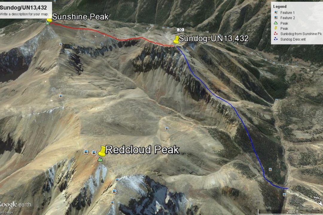
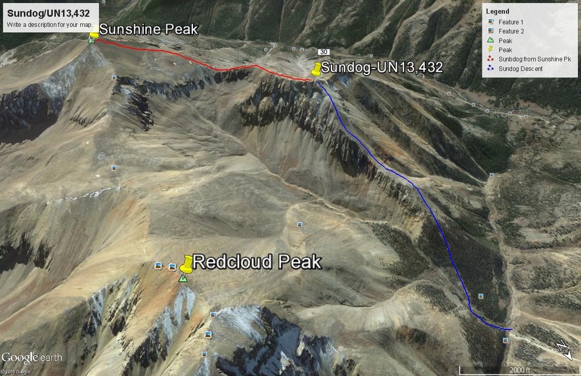
The uninteresting "Sundog" Peak can be easily hiked from the summit of the 14er, Sunshine Peak. Utilizing the same trailhead as for the standard Redcloud-Sunshine ascent, peakbaggers can climb Sundog by following the Redcloud-Sunshine route and then following a connecting ridge to Sundog, or be more adventuresome and blaze their own route, possibly by ascending the north ridge of Sundog from Silver Creek. Class 2 hiking. Pre-Lidar elevation was 13,432.
Sundog SE Ridge Route
-
-
Grizzly Gulch - Silver Ck TH
From Lake City, proceed south on HWY 149 and take the turnoff to the right (south) for Lake San Cristobal a little over 2 miles out of town and after gaining some elevation. Continue south around the lake on the west side and follow CR3 (BLM 3306; CR30 on Trails Illustrated #141) past the Williams Creek, then the Mill Creek (13.2 miles from Lake City) campgrounds to the road intersection at Sherman. (1.2 miles past the Mill Creek CG) Road to here is passable for standard passenger cars. Take the right fork (known as the Cinnamon Pass Road) and begin a steeper ascent into the upper valley. Higher/better-than-average clearance vehicles now advisable. It's a little over 4 miles to the Silver Creek/Grizzly Gulch trail heads used for accessing Sunshine, Redcloud and Handies. From Lake City, it's about 18.5 miles overall and requires the better part of an hour to make the drive. On the weekends, park wherever you can find a place to squeeze in. There is a small parking area on the north side of the road, and the trail for Sunshine/Redcloud begins from the lot. A vault toilet is on the south side of the road with the trail taking off from behind the toilet and a footbridge takes you over the Lake Fork to access Grizzly Gulch and Handies Peak.
Camping
On the east side of Lake San Cristobal, there are two designated campgrounds. South of the lake, there are two more campgrounds: the Williams Creek and the Mill Creek. These typically fill on the weekends. After Mill Creek CG, there are no more designated campgrounds, but there are other at-large, primitive opportunities. Turn off toward Sherman and you may find a spot or two as you drive toward the Cataract Gulch TH. If you continue on up road 3306 to the trailhead for Grizzly Gulch and Silver Creek, some people camp right at the TH parking or on nearby spots, and there are more at-large spots further up the road, but be careful about private property.
Route Description
Year Climbed: 1999Circuitous Route: (This is how we did this in 1999.) From the Grizzly Gulch/Silver Creek TH, follow the standard Redcloud-Sunshine Route used by many 14er climbers that goes up Silver Creek and circles east and southeast to a trail that goes up the north slope of Redcloud. From the Redcloud summit, continue following easy, Class 1 climbers trail over to Sunshine Peak. From the summit of Sunshine, descend NW to a flatter area at 13,300 ft. on very tedious and loose rock, later in the season after the snow melts off. (Class 2) You'll likely find a trail to follow down to here. From the flat area, continue NW to the Sunshine-Sundog saddle at 13,100 ft. on more tundra. Continue NW ascending directly on the ridge toward the prolonged Sundog summit ridge. A rocky cliff band will force you left to find a break (Class 2+) and once above that obstacle, follow the mostly rocky ridge NNW to the high point on the western end.
To descend, drop directly north from the summit on a pronounced ridge. Not too far below the summit is another cliff band with a major interruption that allows easy access through. Continue downhill all the way to the trees on mostly scree and loose but not too difficult rock (unless ascending). Lower down, perhaps at about 11,600 feet, watch for an opportunity to drop right off the ridge (steep and rugged for a short distance) and cross the south fork of Silver Creek, pick up the trail on the other side and head on down to intersect the main Silver Creek trail that you started out on.
Alternate Shorter Route: The alternate route goes up the "descent route" from Sundog as described above. This will reduce overall mileage for the day to about 6 miles and total elevation gain is reduced to about 3,050. Gerry Roach describes this route in his "Colorado's Fourteeners" book as an alternate way to climb Sunshine Peak. See page #286, 28R5 route description.
-