LoJ: #250 (Pre-LiDAR #252) / 13,512' "Petroleum Peak" Formerly UN 13505
Peak Summary
A typical, Sawatch Range, Class 2 summit that requires 4WD to access unless you want to walk extra miles. Nothing particularly difficult about this peak - just mostly pleasant mountain hiking. Formerly known as UN 13505; Lidar increased elevation to 13,512 ft.
Petroleum Peak East Face Route
-
-
Lincoln Gulch - Grizzly Reservoir TH #2
Use this trailhead to access the following summits from the west side of Independence Pass: Grizzly, Garfield, UN 13,460, UN 13,090, both Truro summits, UN 13,631, and Petroleum Peak, all of which are located south of Grizzly Reservoir. The trailhead for Tabor Peak can be accessed from the same 4WD road up Lincoln Creek before reaching the reservoir. Same for the New York Creek/Peak TH. The coordinates provided above are for the Portal Campground located by Grizzly Reservoir. This location will serve as the trailhead.
From the Town of Aspen, drive east up state highway 82 toward Independence Pass. Two miles past the turnoff for the Weller CG, or one mile past the Grottos TH, turn south (right) and drive down toward the Lincoln Gulch Campground. There is an information kiosk right off the highway and a mileage sign for locations along the Grizzly Reservoir/Lincoln Gulch road. Coordinates for this turnoff are: N 39° 07' 10.50" W 106° 41' 18.27". The road immediately crosses the Roaring Fork River. If in a passenger car, you'll need to park either at the kiosk or down at the campground. If you have a 4WD or a better clearance type vehicle, then the road to Grizzly Res. turns off to the left shortly before reaching the campground. The road is rated "4WD." There is a sign indicating the campground is straight ahead with a Forest Service gate. The road to Grizzly "appears" to be in better condition than the one to the campground, but the short road down to the campground is still passenger vehicle passable.
If coming from the Front Range, drive to either Leadville or Buena Vista and turn onto SH 82 from US 24 at Twin Lakes. Drive up and over Independence Pass. On the west side of the pass, drive on past the Lostman CG, and in just under 4 miles past that campground will be the turnoff for the Lincoln Gulch CG. on the left. 4WD or vehicles with better ground clearance may then continue ESE for Grizzly Reservoir as described above. This road is identified as CR23 or FS107.
Along the first 3 miles up to the New York TH, there are 22, designated, primitive campsites with bear-proof lockers for food storage. The road tends to be slow going with potholes, etc., but no real major obstacles. At times, you'll be driving over slabs of rock, but clearance is usually not an issue. We drove the first 3 miles of this road in 2019. While there was one area of extensive avalanche damage and another smaller area, both at about 2 miles in, both had been cleared. It may take over a half hour to drive the 6 plus miles back to the reservoir. There is a small campground there with toilet facilities called the "Portal" campground; first-come, first served.
The trailhead for New York Creek/Peak on the mileage sign mentioned above is 3.3. We measured 3.1. If using that trailhead, the turnoff will be on the right and if you drive a short distance down through some overhanging willows, there is a large parking area with lots of cobbled rock. There is no bridge to assist crossing the creek here. Coordinates are: N 39° 05' 39.23" W 106° 39' 35.51". Elevation 10,100 ft.
The trailhead for Tabor Creek is another 1.8 mile past the signed trailhead for New York Creek/Peak. Coordinates are: N 39° 05' 33.11 W 106° 38' 39.81". Elevation 10,290 ft. There is no bridge to assist crossing the creek.
Just past the Portal campground, in prior years, we have found a locked gate across the road as it continues south up the valley. Because there are some private holdings farther up valley, we've seen some persons with a key to that gate. We've seen the Forest Service keep that gate closed past the 4th of July weekend, depending on snow melt conditions. The gate may also be closed again in early fall. If the gate is open and you have good 4WD clearance, you may continue to drive up valley as far as "Ruby," and the Ruby Mine, right around, 11,400 ft. If the gate is closed, be prepared to walk up to an extra 4 miles, or do as we did one time , and bring mountain bikes and ride up the road as far as you need to go. The bikes won't seem much faster than walking when going uphill, but will speed your return to the campground considerably.
Alternate Trailhead for Petroleum Pk: See the trailhead description for Tellurium Creek north of Taylor Park Res.
Camping
There are two designated Forest Service campgrounds: The Lincoln Gulch CG and the Portal CG at Grizzly Reservoir. In addition, for the first 3 miles as you drive SE to Grizzly Res., there are numerous (22?) "designated" primitive spots for camping. These have been marked by the Forest Service. On summer weekends, both campgrounds and all the designated primitive spots can be fully occupied. Seems to be a very popular area. If the road is open south of the Portal CG, there may be some other, usable primitive sites. Both the Portal and Lincoln Gulch CG have vault toilets, but neither has water. Both have only about 6 sites. The Lincoln CG, you could get an RV or trailer down into, but not the Portal.
Campsite Locations
Lincoln Gulch CG › N 39° 07' 01.72", W 106° 41' 44.39"Elevation 9,600 ft.Portal CG › N 39° 04' 32.82", W 106° 36' 45.35"Elevation 10,560 ft.
-
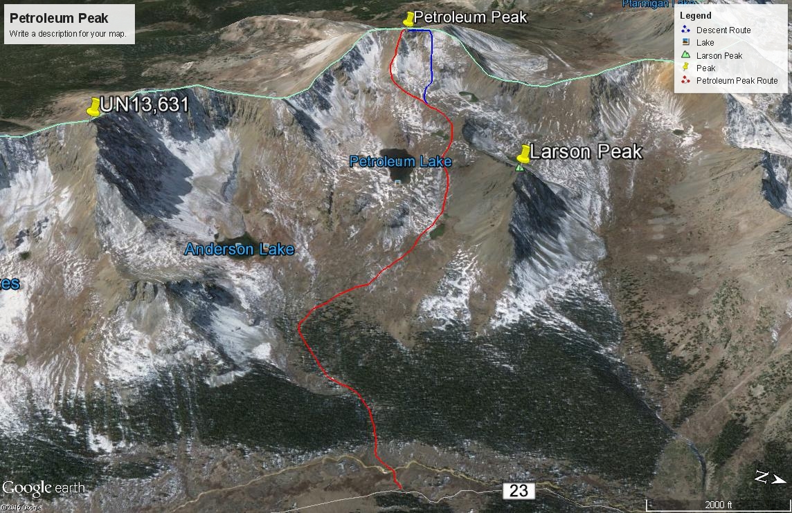
From Lincoln Gulch - Grizzly Reservoir #2 TH via Anderson Lake TH
As indicated in the trailhead description, there may be a locked gate beyond the Portal campground, blocking vehicle access further up Lincoln Creek. It appears that the Forest Service keeps this road closed beyond the Portal CG up until 4th of July weekend, but it all depends on their assessment of road conditions. Therefore, as we said before, if you have a mountain bike(s), you could ride up this road for the 3.25 miles to where the climb for Petroleum Peak begins. This could save considerable time, especially on the return trip. The road, last time we were on it was in generally good condition and not too rugged. Drive, ride or walk this road to these coordinates, where an old jeep track heads off SW for Anderson Lake. N 39° 01' 51.35" W 106° 36' 54.99" Elev. 11,225
Open This Approach in a New Window
Click thumbnail to view full-size photo + captionRoute Description
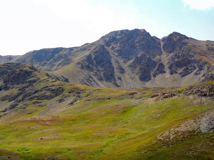
Year Climbed: 1997From the coordinates provided in the "approach," follow the 4WD track down to the creek and wade across. Continue up the track as it heads into the trees and tends SW toward Anderson Lake. The White River NF map shows this track as trail #116 up to Anderson Lake. From the lake, another trail breaks off, designated as #1991and leads over to Petroleum Lake. You can either follow the two trails as marked or, as you head up the 4WD track, as you reach the last trees, and not long after passing a small cabin, bear right to the NW and shortcut your way up towards Petroleum Lake. Once out of the trees, it's tundra & grass terrain, and in mid summer, flowering meadows.
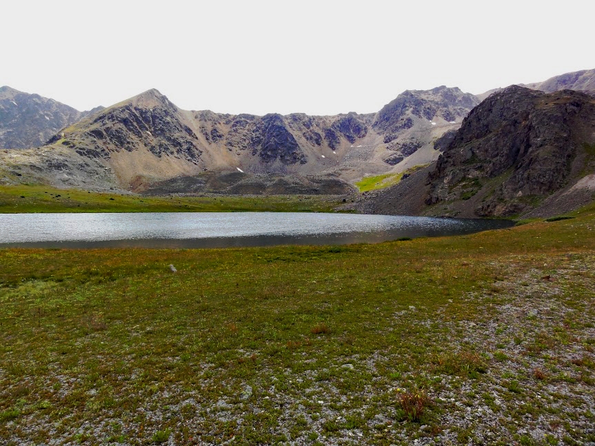
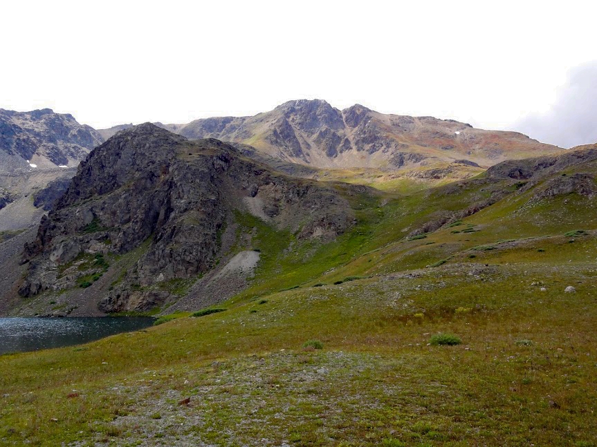
Walk past a small tarn at 12,000 ft., and skirt Petroleum Lake on the north and west side, staying well above and gain a broad ridge west of the lake and SE of a small, unnamed, crescent-shaped lake at 12,600 ft. Follow this broad ridge as it turns more directly west and leads straight to the summit. As you gain elevation, what had been mostly tundra conditions will give way to typical rock rubble, etc. If you're early enough in the season, you may find plenty of snow to hike on above Petroleum Lake.
For a descent, if you brought an ice axe and there's still some snow left, you can make a nice glissade back down by walking north from the summit a little and then heading down a steep snow field to the east. After 600 feet of elevation loss, reconnect with your ascent route and continue down.
-