LoJ: #254 (Pre-LiDAR #248) / 13,505' UN 13505 Previously UN 13510 A (G&M)

Peak Summary
Note: In older versions of G&M this peak was listed as UN13502 with an elevation of 13,502 and a ranking of 255, using the older Bristol Head 15 map. The Baldy Cinco 7.5 minute quad now corrects the elevation to 13,510. LoJ and Lidar have now adjusted the elevation down 5 feet to 13,505 ft.
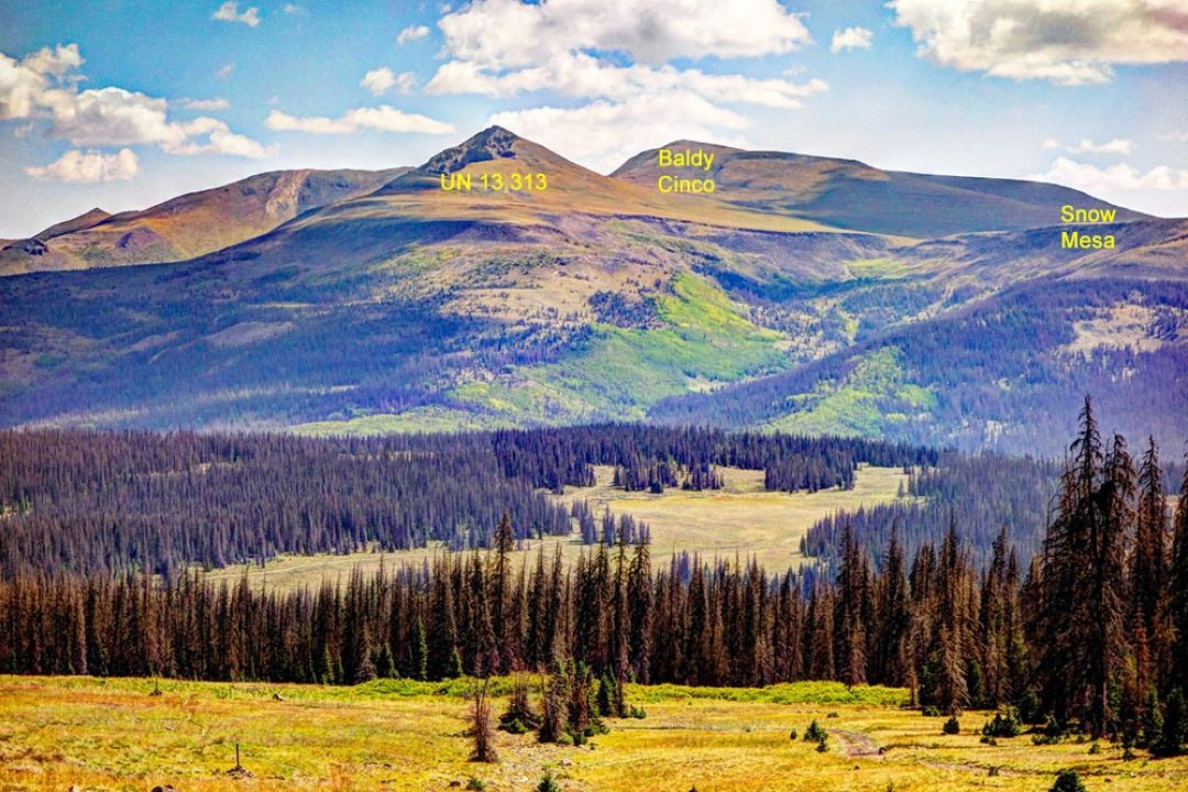
UN 13,510 is the fourth summit in a sequence of four 13ers located on the north end of Snow Mesa - a vast, high altitude plateau east of Spring Creek Pass. The four 13ers can all be easily hiked in a single day from the Spring Creek Pass. UN 13,510 is basically a Class 2 ascent that utilizes a section of the Continental Divide Trail. The trailhead is located at Spring Creek Pass and is accessible to all passenger vehicles on CO149 from either out of Creede or Lake City.
UN 13,510 South Ridge Route
-
-
Spring Creek Pass - Snow Mesa TH
From the main intersection in Creede where CO149 reverses direction after crossing the creek, drive 33.0 miles SW, then north to the uneventful summit of Spring Creel Pass. The Snow Mesa/Continental Divide Trail heads out from the east side of the highway. On the west side of CO149, you can drive in on pavement and there's a small parking area for trail hikers with a vault toilet. The road continues to a circle where there are some picnic tables and another vault toilet. This use to be a campground but is now technically closed to camping. There's no water available here. The Continental Divide Trail also continues to the west and heads up onto Jarosa Mesa.
If coming from Lake City, drive south from town on CO149, remain on CO149 when the turnoff for Lake San Cristobal comes in on the right, and begin the long, steep climb to the summit of Slumgullion Pass. CO 149 then descends south from the pass winding through beetle-kill forest that has been cleared back from the highway and open, attractive meadows. Farther down are nice stands of aspen. The highway then makes one short gain to reach the summit of Spring Creek Pass. From Lake City, it's 17.3 miles to the summit of Spring Creek Pass as described above. It takes a good half hour to make the drive from Lake City.
Camping
There are three national forest campgrounds close by. They are: Slumgullion - at the top of Slumgullion Pass; South Clear Creek Falls and North Clear Creek. The South Clear Creek has been closed for some time but reopened recently from what we could tell. The Slumgullion is located in the midst of a lot of beetle-kill mitigation. A little farther drive away are the Rito Hondo CG at Rito Hondo Reservoir and Bronw Lakes, which is a state park area. South of Spring Creek Pass is your best chance to locate primitive sites.
-
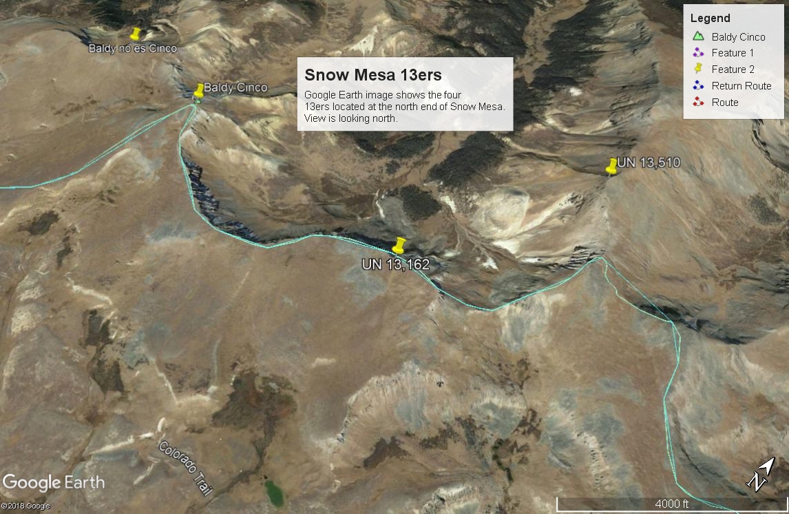
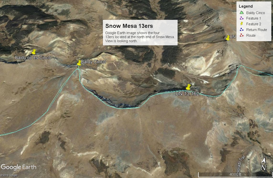
From "Baldy no es Cinco" Baldy Cinco UN 13173
-
Baldy no es Cinco South Slopes Class 1 / 4.6 mi / 2,415’ One-Way
Open This Route in a New WindowThough LoJ classifies this summit as Class 2, in our opinion, it's really only a Class 1 walk-up. The only reason we can think of for calling it Class 2 is the overall mileage.
From the trailhead parking area on the west side of CO149 at Spring Creek Pass, walk across the highway to locate the beginning of the trail up to Snow Mesa. This is trail #787 and is a section of both the Continental Divide Trail and the Colorado Trail system. The well-maintained trail leads up through fairly open, beetle-kill forest. The first 1,000 feet of gain are moderate and the next 400 feet of gain are steeper as the trail mounts Snow Plateau. The plateau is a vast stretch of tundra that continues both east and south for a significant distance at an average elevation of 12,200 ft. The north end of the plateau is where the 13ers are located. The south slopes of all the 13ers are more gentle as they drop down to the flatter plateau. The north edge of the peaks and the entire plateau drops off markedly with cliffs and broad valleys leading north. Once on the plateau, the trail is clear at times and vague at others but usually marked with stakes, etc.
When you find yourself SSW of UN 13,313, break off from the CD/Colorado trail and head north across the tundra toward the first destination of the day. Contour around the Cebola Creek basin to avoid elevation loss and continue north, heading straight up the lush, grassy tundra for the next 1,100 feet. Once on the summit, the west face drops off in dramatic cliffs while a more gentle ridge heads north toward Tumble Creek. You may see trails from both game and domestic sheep grazing. The valleys north of and below the north edge of the plateau seem to offer prime elk habitat. See if you can spot any. If doing a family hike with younger ones, you may want to consider calling this summit a day. If you're a committed peakbagger, head on over to Baldy Cinco.
-
Baldy Cinco NW Ridge Class 1 / 0.9 mi / 485’ One-Way
Open This Route in a New WindowBaldy Cinco is the second in a sequence of a four-summit group of peaks. One wya mileage and elevation gain are measured from the summit of Baldy no es Cinco. Round-trip mileage and elevation gain assume completion of the sequence.
From the summit of Baldy no es Cinco, descend along the ridge to the NE to about where it turns more to the north, then take a right and head downhill to the SE to a saddle at 12,900 ft. From the saddle, there's a well-defined game trail. Continue a little more easterly and steeply to the summit of Baldy Cinco. The entire traverse is almost all tundra with one modest section of rubble/talus on the way up to Baldy Cinco. Enjoy the continuing expansive views in all directions.
-
UN 13,168 West Ridge Class 1 / 1.9 mi / 493’ One-Way
Click thumbnail to view full-size photo + caption
Open This Route in a New WindowUN 13,168 is the third in a sequence of a four-summit group of peaks. One way mileage and elevation gain are measured from the summit of Baldy Cinco. Round-trip mileage and elevation gain assume completion of the sequence.From the summit of Baldy Cinco, make a descent down the gentle SE ridge of the peak which will turn east, then NE (with a steeper drop) to a saddle with an elevation of 12,669 ft. From the saddle, continue walking east along the ridge crest to the summit of UN 13,168. This entire traverse of nearly two miles is on almost all grassy tundra with a short area of talus/rubble as you approach the summit of UN 13,168. Again - it's all very easy so we keep the classification at Class 1. The summit is mostly tundra-covered with rocks strewn around, nestled into the grass and flowers. The summit also affords an outstanding view of Snow Mesa as it stretches southward toward Creede.From this summit you can easily drop down and pick up the CD/Colorado Trail to return to Spring Creek Pass. Doing so would save an additional 3.5 miles of walking or so, and you could get back in time for dinner easily, but then you would leave UN 13,505 hanging. So why not finish it all up and continue on to UN 13,505?
-
Click thumbnail to view full-size photo + captionRoute Description
Year Climbed: 1997UN 13,510 is part of a four-peak sequence of summits on Snow Mesa. One way mileage and elevation gain are measured from the summit of UN 13,162. Round-trip mileage and elevation gain assume completion of the entire sequence of four summits.
From the summit of UN 13,162 descend ENE to a saddle at 12,540 ft. This is a steeper drop but still on a largely grassy slope. In mid-July, we still found some snow to glissade on. At the saddle you will intersect the CD/Colorado trail here. From the saddle, you could continue directly NE along the ridge crest, but if you wish to avoid a rockier section of that ridge, follow the CD/Colorado trail east a few hundred yards, then turn north, off the trail and hike north and back to the NW on a flower-strewn slope to regain the ridge above the rocky section. The south ridge of UN 13,510 then eases for a while. The only challenge remaining as you walk on north is the final stretch along the ridge that becomes rockier before reaching the uneventful summit. This particular peak appeared to be laced with multiple domestic sheep trails. Admire the vast expanses and large valleys of the La Garita Wilderness that lie north of the Continental Divide. If you complete this hike as described, by this point you will have covered nine miles and gained over 4,300 feet in elevation, plus two of the summits are officially "continental divide" summits.
Now for the more tedious part - the return hike. From the summit of UN 13,510, return back to the CD/Colorado Trail at the saddle at 12,540 ft. Follow the trail south as it drops off the divide and contours across steeper terrain to descend to the flatter Snow Mesa. Near a pond on the mesa, Trail #787 (CD/Colorado Trail) can be followed directly west for the remaining straight, mostly flat miles back to Spring Creek Pass. You're likely to encounter backpackers and other users along the way. There are no trees for shelter. Since it's likely that it will be afternoon for this afternoon hike back, be prepared for some weather. We found the trail to be vague at times but marked well-enough with posts and cairns to keep us on track. For reference/comparison/planning purposes, it took us nine hours to complete this sequence.
Additional BETA
Links to other information, routes & trip reports for this peak that may be helpful. -