LoJ: #231 (Pre-LiDAR #240) / 13,541' "Cataract Peak" Formerly UN 13,524
Peak Summary
Garrett & Martin list this peak as UN 13524 A. Lists of John assign the name "Cataract Peak" to help distinguish from UN 13524 (Peak of the Clouds) on the Rito Alto Quad. USGS quad shows the high point east of the Tundra Top-Cataract connecting ridge. Google Earth shows a higher elevation more to the west end of the summit ridge. GE elevations we do not find to be all that accurate. Lidar measurements added 17 feet to this summit.
Cataract Peak is most easily climbed by going over the summit of UN13,450 otherwise known as "Tundra Top" or some older sources called it "Meadow Mtn." While Tundra Top is a mellow Class 1 hike, we'll give Cataract a Class 2 rating because of some scree conditions to manage. Our suggested route involves a backpack trip into this area from Carson Pass. A 4WD vehicle will be required for this route. If you don't have 4WD, then the best access point will be the Cataract Gulch Trail. More about that in the route description area.
Cataract Peak South Ridge Route
-
-
Carson Pass TH
Most of the 13er summits on the Pole Creek Mountain quad and the Finger Mesa quad can be most easily accessed from one of two trailheads, both off of County Road 3, south of Lake City and Lake San Cristobal. The first TH is Carson Pass at the head of Wager Gulch. This access requires 4WD with good clearance. The drive in is followed by walking the Colorado/Continental Divide Trail west. There is minor elevation gain and loss and no more than 4 miles of hiking/backpacking. The other trailhead is accessible to passenger cars, but requires more elevation gain (2,500 ft.) on foot. That access utilizes the Cataract Gulch Trail from near "Sherman." It's about a 4.5 mile hike/backpack up to Cataract Lake for a base camp. We used the Wager Gulch/Carson Pass access, hence our trip reports will be based on that as the start point. Peaks accessed in this manner include: Coney BM; UN13,260 D; Bent Peak; Carson Peak; "Tundra Top;" Cataract Peak; Half Peak; UN13,674(Quarter Peak); UN13,581; UN13,580 A; UN13,660; and Pole Creek Mtn. For information regarding the Cataract Gulch TH, you can find that by searching for that trailhead. We have never actually hiked that trail except in the vicinity of Cataract Lake. Our route descriptions for many of these peaks should be usable regardless of which TH you choose with the exception perhaps of Bent, Coney BM and UN 13,260 D.
Wager Gulch/Carson Pass
From the Town of Lake City, drive south on SH149 and then turn right onto CR3 (BLM 3306) to Lake San Cristobal. Trails Illustrated labels this road as CR30. The road is paved past the lake then turns to graded dirt, passable for all passenger cars. About 2 miles past the Williams Creek campground, watch for a road turning off to the left (south) for the old townsite of Carson. This road is identified on maps as either BLM3308 or FS568. it's also called the "Wager Gulch" road. From this point on, 4WD is advisable.
Head up the road through aspen and conifer forest. At times, the road climbs steeply, but generally is not too rocky or in very poor condition. Along the drive up, there are a few primitive campsites. See coordinates below for what we consider to be the best primitive camp area. The road is fairly easy driving to the old townsite of Carson. Beyond there, it works its way up to Carson Pass through areas of willows and becomes quite rocky in stretches. We drove this summer of 2018 and found that a lot of the willows had been cleared away and though rocky in stretches, the road was easily passable in our Toyota Tundra. If you're not comfortable with driving this last part, park down near Carson and walk this last mile. From the summit of the pass and the coordinates provided above, you can begin your hike or backpack. In previous years, it was possible to continue driving south on a 4WD track for another half mile to where you would actually connect with the Colorado trail. Those coordinates are: N 37° 50' 52.67 W 107° 22' 06.06". Elevation here is 12,150 ft. so you've dropped down from the pass a little.
Camping
There are designated, Forest Service campgrounds at Lake San Cristobal, Williams Creek and Mill Creek (which is past the Wager Gulch turnoff). On the drive up Wager Gulch, we observed a few nice, primitive sites at some level locations. The best location was just a little before reaching the road that turns off for Carson. There is some open meadow on either side of the road and a good cam area on the west side. Be advised though that the beetle kill all through here is heavy and there are numerous dead trees around this camping location. See coordinates below.
Campsite Locations
Carson Primitive Site › N 37° 52' 46.78", W 107° 21' 49.41"Elevation 11,240 ft.
Click thumbnail to view full-size photo + captionRoute Description
Year Climbed: 1992From either Carson Pass, or a half mile to the south from the pass, you want to connect with the Colorado Trail and head west. The trail drops down in elevation some toward Lost Trail Creek, then easily regains elevation to a non-descript, tundra pass that separates the Lost Trail drainage from the Pole Creek drainage. If you're backpacking in, we found a good campsite location about one mile west of this pass in the open tundra, on a bench not far from an overlook of Cataract Lake. Warning: There may be a large herd of domestic sheep grazing in this area.
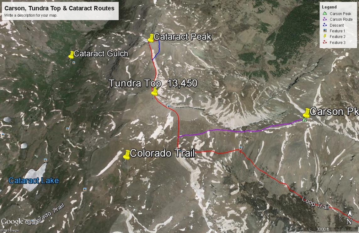
From the Pole Creek/Lost Trail Pass, turn north and ascend mostly tundra-covered slopes with some scree higher up to the ridge that connects Carson and Tundra Top. At the ridge, turn west and amble on to the large summit area of Tundra Top, peering occasionally over to the north and looking down the dramatic cliffs. When we climbed this summit in 1992, the summit register identified this as "Meadow Mountain." From Carson Pass, you can probably do this peak alone, easily in a half day, but why stop with one? Cataract Peak is just north, less than a mile away.
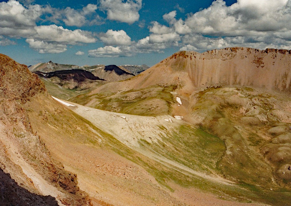
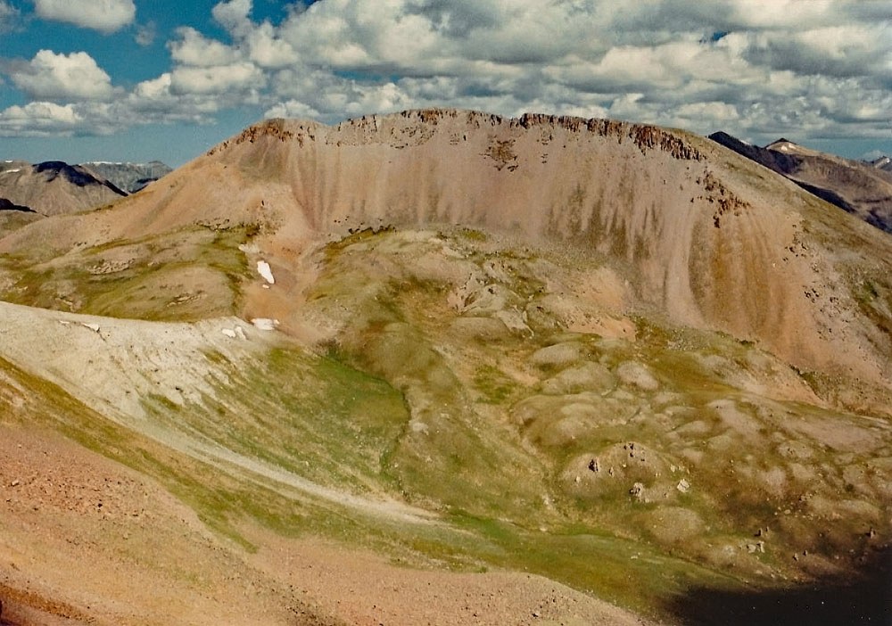
Drop north off the summit of Tundra Top and follow directly on the ridge that connects over to Cataract Pk. A steep, loose rocky section will quickly give way back to the tundra so prevalent in this area. From the connecting saddle, head NW towards the peak, using game and sheep trails to lead to a SW ridge that you can follow to the main summit ridge. About 300 feet of this ascent will be on steep, very loose, pebbly scree. A minor cliff band near the top should not prove an obstacle. Once through it, you can stroll east to the summit. As you make the traverse from Tundra Top to Cataract, you may want to watch carefully down in the Mill Gulch basin to the east. This isolated basin seems to attract a fair sized herd of elk.
For the return, you can use that steep, loose scree to your advantage. From near the summit, we walked back west just a little to a break in the cliffs and did a scree-ski descent for about 400 feet down the south face. Then we contoured back over to the saddle and regained Tundra Top. From Tundra Top, if you have not already climbed it, you can easily traverse over to Carson Peak, See the route description for that summit.
Additional BETA
Links to other information, routes & trip reports for this peak that may be helpful. -