LoJ: #587 (Pre-LiDAR #589) / 13,078' UN 13078 Formerly UN 13075
Peak Summary
This little Class 1 summit is about as easy as they come. If you have 4WD, you can drive to within less than 400 feet of the summit. If you want to make it a little more sporting, or don't have the 4WD, there are two pleasant routes to the summit that will still only involve 3 miles of hiking one way. This summit sequences easily with Hanson Peak and you can still keep it at a half-day hike. Lidar increased elevation by 3 feet.
UN13,078 West slope Route
-
-
California - Placer Gulch TH
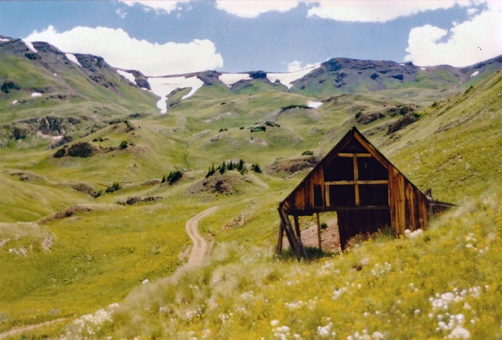
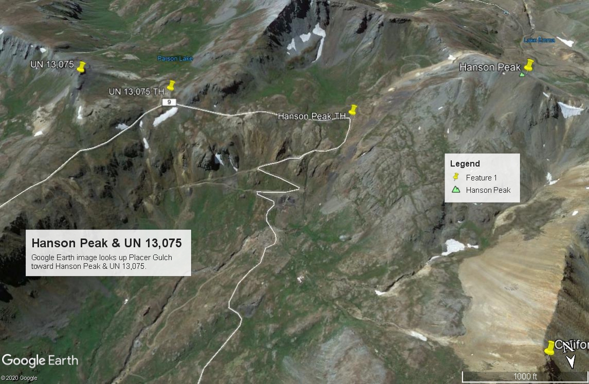
From the Town of Silverton, drive east on the main road through town to where the paved road splits one block past the courthouse and veer right onto the blue-signed County Road 2 (set odometer here) for 4.2 miles of nicely graded dirt road to Howardsville. (On Trails Illustrated map #141, this road is labeled #110. Pavement ends after 2 miles. This road is also known as "The Alpine Loop Road and BLM 4500.) From the Howardsville intersection, continue north another 4.3 miles to the old site of Eureka. The road will cross to the west side of the Animas River and continue up a steeper shelf section. The road begins to get a little more difficult and enters a more narrow section of the Animas River canyon. At about 10,740 ft., the valley begins to widen out again. In that location, another road heads off to the left for Picayne Gulch. It is possible to reach UN 13,075 and Hanson Peak by going up this way, but the lower section of this road is intensely steep, so only for lower gear ratio 4WD vehicles. The easier way is to continue north, still on the main road and take the turnoff on the left for Animas Forks. There are actually two roads that will take visitors into Animas Forks. We suggest the first one you come to which will drop down and cross the river, then ascend back up to the old mining site. Past Animas Forks, drive west on BLM Road 4505, which on Google Earth is identified as CR19. Trails Illustrated does not designate the road with any number. At Animas Forks, the road becomes rated more of a 4WD on the Gunnison NF map and the USGS map from 1955, however, the FSTopo 2016 shows it as not rated for 4WD. When we drove it, it was in good shape and our Jeep Cherokee handled it easily. From where the two roads to Animas Forks converge, it's a 1.2 miles west on CR19 to the turnoff for Placer Gulch and a place to park to begin the hike up that gulch. Google Earth designates the road up Placer Gulch as CR9.
For Tuttle and Houghton, continue on CR19 from this intersection for another .7 mile and park on the left side of the road at these coordinates: N 37° 55' 48.76" W 107° 36' 16.92". Begin the hike for Tuttle & Houghton from here, however, it's also possible to just park and begin your hike from the California - Placer Gulch intersection.
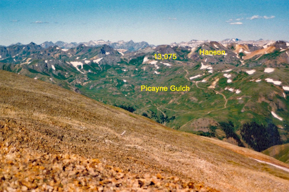
If you have 4WD with good clearance, it's possible to drive on up all the way to the foot of Hanson and then continue down Picayne Gulch back to the main Animas Road on this CR9. The road in general is good up to about 12,200 ft. where it begins to climb more steeply on switchbacks at the Gold Prince Mine site. It becomes more rocky here. At 12,600 ft., a short road breaks off to the south that makes a good parking spot for hiking Hanson. If wanting to continue on from here to the east, it's an easy drive over to the saddle just west of UN 13,075 and some parking that overlooks Parson Lake. From UN 13,075, the road heads NE down Picayne Gulch. The upper portion is in a wildflower/tundra basin. As the road descends, it becomes steeper and almost intensely steep farther down. But, we never found it to be difficult to drive as far as rock hazards and clearance issues were concerned. Keep in mind, this was a number of years ago. With all the ATV/ORV/4WD activity that has become much more popular in this area, the road may be in much worse shape.
Camping
There are no official Forest Service campgrounds in the upper Animas River valley and summer weekends can see a swarm of campers in this overall area. Something of an "RV" village tends to build up at a large flat area along the river opposite the Maggie Gulch turnoff and then at the ghost town of Eureka, there's a number of campsites east of the river. This area is now a pay-campground. There is a store here called, "The Miner & Prospector Store." Campsites as of 2021 were $20 or $40 with electric. It is best to make a reservation by going to www.eurekacampground.com or contacting [email protected]. Cabins are also available at $75 per night and hot showers may be obtained for $10.
The best campsites we have found are along the spur road that leads to the trailhead for the South Fork of the Animas, aka: The"Boulder Gulch" trailhead. The road that heads into there has several primitive sites. Lastly, you could just camp at the switchback for the trailhead to Bonita. This location is open with no trees for shelter. None of these locations have facilities of any kind.
The best campsites we have found are along the spur road that leads to the trailhead for the South Fork of the Animas, aka: The"Boulder Gulch" trailhead. The road that heads into there has several primitive sites. One could also just camp at the switchback for the trailhead to Bonita. This location is open with no trees for shelter. None of these locations have facilities of any kind. Lastly, we spotted some reasonable sites in Picayne Gulch. If you turn off the main Alpine Loop Road where the Picayne Gulch Road first comes in a couple miles south of Animas Forks and drive up the CR9, there will be a branch road that heads off and climbs a ridge with trees on the south side of the gulch. Eventually that road rejoins the main Picayne Gulch Road at a switchback at 11,800 ft. We noticed some campsites along this spur road in the trees before it rejoins the main road.
-
From Hanson Peak
Click thumbnail to view full-size photo + caption
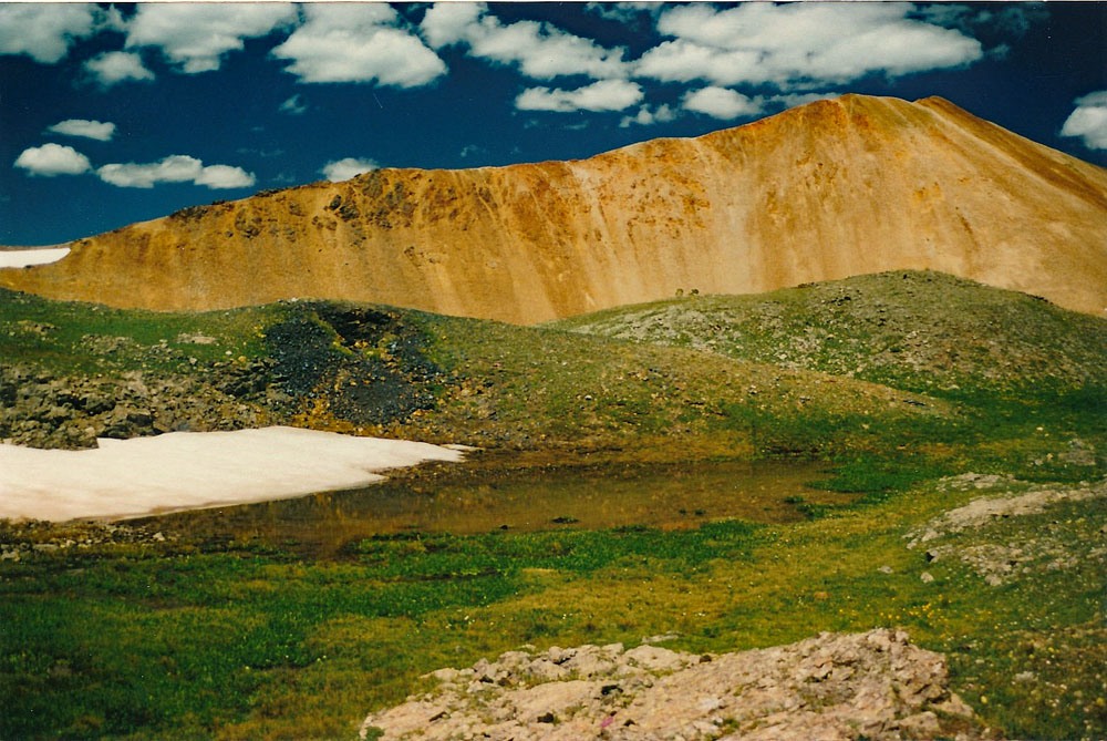
Open This Route in a New WindowFrom the trailhead where California and Placer Gulches join, walk south up the road (CR9) that heads up Placer Gulch. If the road walking is too boring, you could walk down in the creek bottom. The willows are not too bad. As the road approaches the Gold Prince Mine, take a few minutes to look among the ruins, then continue following the road to a somewhat flat area at 12,600 ft., where the road will turn sharply east. (Parking available here for 4WD.) From this point, walk SW on mostly tundra to a saddle that's south of the Hanson summit. At the saddle, turn north and finish the last 300 feet of gain on scree and rock.
When you arrive at the summit, try to find Lake Emma, indicated on the USGS quad as SW of the summit. (Hint: you won't find this lake because it was accidentally drained by mining activity.) To read an interesting story, check out this link:
http://rocktumblers.blogspot.com/2012/03/silverton-colorado-one-of-worst-minding.html
When it's time to head down, why not try another route to add a little interest to an otherwise uneventful hike? We hiked down on the east flank and at about 12,800 feet found a nice bench area with a small tarn and beautiful, lush grass with a small creeklet that flowed from a snowbank. This place just invited a leisurely time to cool your feet and eat some lunch. Then you can just continue on down with one steeper slope of rocks to negotiate to get back to the road. Hike on back to your vehicle - wherever you left it, or make a short jaunt east along the road and tag UN13,075 before calling it a day.
Bonus Points: Climb UN13,075 while you're here. It will take less than an hour. Then also include California Mountain, north of Hanson. California is classified a "soft rank" summit, so it might be worth the effort. You can easily exit east from the summit of California and descend some scree before reaching mostly tundra back to the road in Placer Gulch and return to your vehicle.
Click thumbnail to view full-size photo + captionRoute Description
Year Climbed: 2002UN 13,078 is sequenced with Hanson Peak. One-way mileage and elevation gain are measured from the summit of Hanson. Round-trip mileage and elevation gain assume completion of the sequence.
From the summit of Hanson Peak it would be entirely possible to walk the connecting ridge over to UN 13,078. This would be a Class 2 route with no real difficulties on mainly tundra and scree/talus. Following this ridge will take you to the saddle west of UN 13,078 that overlooks Parson Lake.
For another way over, descend Hanson as we suggest on the east flank and hike back to the suggested parking for 4WD vehicles. Simple walk east along the road that heads for Picayne Gulch over to the same saddle overlooking Parson Lake. From the saddle, chose your route up either the west flank of UN 13,078 or contour around a bit to the north ridge and follow it south to the summit. From the saddle, the 400 feet of gain will be mostly on tundra, then when you reach the summit ridge, you'll have a little bit of rocky rubble and chiprock along a narrow ridge to manage before arriving at the summit.
Return by the same route. If you're in a 4WD and have parked nearby, (the saddle overlooking Parson Lake is a good spot), you could continue driving down Picayne Gulch and rejoin CO 110 a little over two miles south of Animas Forks. Going down Picayne Gulch won't put your vehicle to as much "test" as driving up. This is a very steep road in places, but when we drove it, we did not find it to be too rough.
Bonus Points: California Mountain, which lies north of Hanson, was classified a "soft rank" 13er, but is no longer regarded as such due to Lidar. As easy as it is to get to it, it might be worth a little extra effort to do so, and you could easily descend east and rejoin the Placer Gulch road to get back to your vehicle.
Additional BETA
Links to other information, routes & trip reports for this peak that may be helpful. -