LoJ: #532 (Pre-LiDAR #528) / 13,145' "Jackass Point" Formerly UN 13145

Peak Summary
An easy, mostly trail and tundra hike above Telluride with excellent views. Good family hiking with two possible approaches. Class 1 tundra stroll. Combines well with La Junta and Wasatch peaks for a longer but doable day. Trailhead is accessible by higher clearance vehicles. Descent is more of a Class 2 affair if you go down Jackass Basin because any old road has been all but overgrown and hard to follow, thus, some bushwhacking.
Jackass Point South Ridge Route
-
-
Bridal Veil Basin TH
From the Town of Telluride, on the main street (Colorado Ave.) drive east out of town and continue on the same road which becomes the Black Bear Pass road, labeled as CR648. This road will climb above some mine ponds on 5-6 switchbacks and then straighten back out to continue SE and closer to Bridal Veil Falls. The road will cross Ingram Creek and shortly after begin the series of switchbacks that take you up the mountainside to Black Bear Pass. There is some room to park at the 4th switchback for the Via Feratta route, but for the trailhead to Bridal Veil Basin, continue for two more switchbacks and finish heading south to the trailhead parking, a little above Bridal Veil Falls and the historic power plant. Be careful not to venture any farther up the Black Bear Pass Road. Beyond the Bridal Veil TH, the road is one-way to the west.
Camping
There is no camping available in this immediate area unless you pack in for a ways. At-large camping anywhere near Telluride is difficult to come by and generally not allowed. The nearest campground is located along HWY145 about 5 miles south from "Society Junction." That's the "Sunshine" Campground. You may be able to find some at-large spots on 63J south of Illium or back along HWY145 before climbing the big hill into the Telluride Valley. There are several at-large spots along the highway, but be careful of private property. There is also a campground located on the east end of the town at the town park. Campsites are available on a first-come-first-served basis. These links offer more information:
http://www.telluride-co.gov/DocumentCenter/View/623
http://www.telluride-co.gov/181/Campground
-
From Wasatch Mountain La Junta Peak
-
Wasatch Mtn NNW Ridge Class 2 / 4.25 mi / 3,215’ One-Way
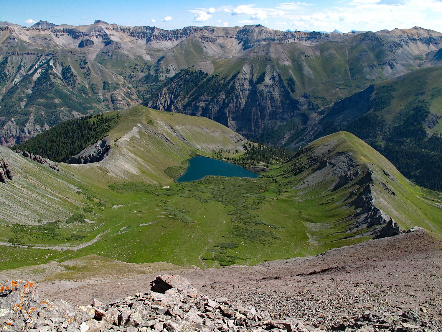
Open This Route in a New WindowFrom the TH above Bridal Veil Falls, follow this popular day hiking route south into Bridal Veil Basin. The old mining road provides easy access to the upper basin area. It remains on the east side of Bridal Veil Creek and a couple of times, switchbacks up the mountainside to gain elevation. At about 1.5 miles in, the road forks, the left of which heads up to Blue Lake. Continue hiking on the less used right fork instead and continue along Bridal Veil Creek for appx. another 1.5 miles. About 1/2 mile from the previous junction, the road/jeep track will cross the creek and begin climbing on the hillside to reach a bench area below Wasatch, passing by a pair of small tarns at about 12,190 ft. Soon after, the road begins to play out.
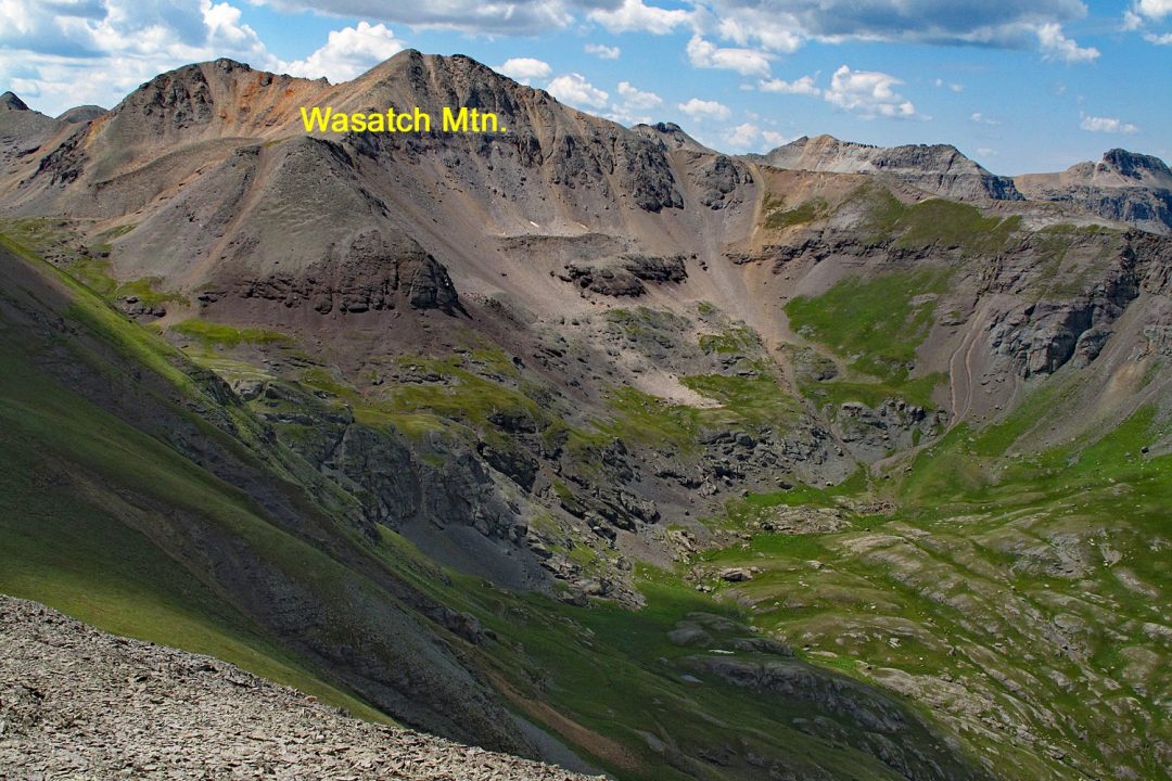
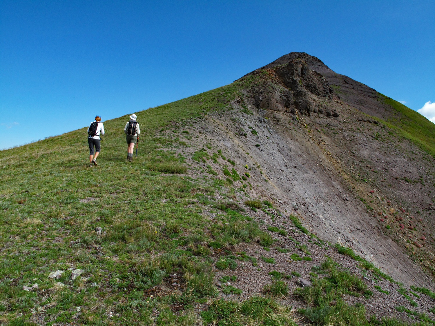
From the two small tarns, walk uphill west, staying on the south side of the creek and head in the general direction of the Wasatch/La Junta saddle. This route will take you up a series of tundra benches with intervening rocky outcrops. You should intersect an old road/trail that goes on to cross the saddle and shortly after that, a small tarn at 12,815 ft. that shows specifically on the USGS map below the NNE ridge of Wasatch. A steeper tundra slope to the south of the tarn leads west to a saddle on the NNE ridge of Wasatch. Once at the saddle, it's an easy walk on mostly dinner-plate talus to the summit, another 400 feet up.
For your return trip, either descend by the same ascent route, or hike back down to the Wasatch/La Junta saddle and include La Junta in your days agenda as well as Jackass Point for a 3-peak day.
-
La Junta SSW Ridge Class 2 / 0.9 mi / 620’ One-Way
Open This Route in a New WindowLa Junta Peak is the middle part of a sequence of three summits which include Wasatch Mtn. and UN13,145 (Jackass Pt.) One-way mileage and elevation gain are measured from the summit of Wasatch Mtn.
Follow the trail head and approach directions for Wasatch Mtn. as far as the small pond at 12,815 feet near the saddle between Wasatch and La Junta. If climbing Wasatch first, make your ascent and then turn around and descend the NNE ridge back to the same saddle avoiding one steep, rocky section along the way by staying right of the ridge crest. From the saddle at 12,860 ft., begin your ascent of La Junta walking steeply up over loose rocks (talus) and gravel at times for the 620 feet to the summit.
From the summit of La Junta, either continue north to Jackass Point or if done for the day, return to the Wasatch/La Junta saddle and hike back out to the Bridal Veil trailhead.
-
Click thumbnail to view full-size photo + captionRoute Description
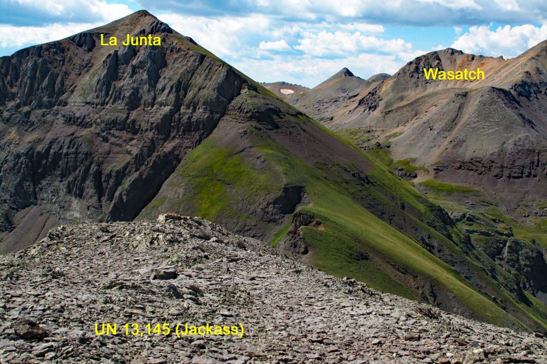
Year Climbed: 1996UN13,145 (Jackass Pt.) is the third summit in a sequence with Wasatch Mtn. and La Junta Peak, all on the east side of Bridal Veil Basin. One-way mileage and elevation gain for Jackass are measured from the La Junta summit.
From the summit of La Junta, descend the NNW ridge of the peak down to the connecting saddle with UN13,145. The descent is mostly on tundra with a minor cliff band that's easily avoided. At the saddle, continue straight north to the summit of UN13,145 over tundra with chiprock at the summit. This entire traverse is really Class 1 terrain but we give this peak an overall Class 2 rating because of some of the difficulties in finding your way back down through Jackass Basin and into the lower section of Bridal Veil Basin and the trailhead.
To descend, go back some toward the Jackass/La Junta saddle and then drop east into Jackass Basin. As you descend, you'll enter into lower flanks of the peak covered in a beautiful array of wildflowers with a lot of orange paintbrush mixed in. Once in the basin, hike NE, staying on the north side of the basin to avoid swampy areas filled with plentiful Marsh Marigolds. At the east end of the basin, locate the remains of an old cabin, probably much more deteriorated now than when we passed by in 1996. From the cabin, we were able to locate the old mining trail that shows on the USGS map that comes up out of Bridal Veil Basin. Follow this trail down to the best of your ability. With all the overgrown vegetation, it's easy to lose at times. We had little difficulty in finding the trail into Silver Lake Basin at Pt. 11,146, but after that we lost the trail for quite a while until we neared the bottom and Bridal Veil Creek. Make the best of it and thrash your way through. At least you can see where to go. Once back on the Bridal Veil Basin trail, walk easily back to your vehicle. The entire loop of three summits can be completed in about 7 hours or less.
Alternate Route for UN13,145 alone: We did this hike in 2013. From the main street in town, (Colorado), turn south onto Pine and drive about 4 blocks south to the parking area for the Bear Creek trail, which begins behind some condominiums. This is a very popular summer hiking route. Parking is very limited around here. Hike across the creek on a bridge and begin the trek into Bear Creek canyon on a wide, old roadbed. Continue walking south for about 1.75 miles to an open area where you should see a trail heading off to the left and down to the creek. Lots of people often stop in this area. Find a way to cross the creek and then get to the north edge of an avalanche chute that tumbles down to the creek from La Junta Basin. This chute is very visible from the Bear Creek Trail. As you head up along the chute, you should pick up a trail that continues climbing along the northern edge of the chute on numerous switchbacks. About 1,200 feet up, the trail will cut through some cliffs making for some dramatic trail shots and then will contour around the basin over some difficult talus sections, cross the creek and head up through low willows to a moderate bench area at 11,600 ft. At or slightly above 12,000 ft., break off from the main trail that continues to the Wasatch/La Junta saddle and follow some old roadbeds as they climb up toward the La Junta/Jackass saddle. Wherever you like, leave the old roads and walk through verdant tundra to the saddle, then turn north for your finish. Because there is more elevation gain to this route and greater mileage, it would not be suitable for younger children. Best for middle school age and up. Overall distance is about 8 miles round trip with 4,400 feet of gain and we rate this as Class 2+ because of the steepness of the ascent out of bear Creek. Plan on around 6 hours.
Additional BETA
Links to other information, routes & trip reports for this peak that may be helpful. -