LoJ: #471 (Pre-LiDAR #460) / 13,220' UN 13220 Formerly UN 13222 A

Peak Summary
A Class 3 scramble near the summit (some Class 4 possible depending on exact route taken) with an otherwise nice approach trail into an isolated basin from the Middle Fork of the Cimarron trailhead. Drive to trailhead possibly accessible by passenger car but better clearance advisable in case of road washouts. Lidar reduced elevation by 2 feet.
UN13,220 NW Ridge Route
-
-
Middle Fork of the Cimarron River TH
From either the West Slope or East Slope:
From Montrose, drive east on US50 past Cimarron about 2.7 miles and turn south on County Road/Forest Road 858 that goes to the Silverjack Reservoir. From Gunnison, drive west on US50 past the Blue Mesa Reservoir, down through a narrow canyon section, up over a pass at 8,700 ft., then down a long and winding descent toward Cimarron. The turnoff is one mile past the turnoff for CR864 and just past a small resort on the south side of the highway. It's a long, 22 miles drive back on a graded, dirt road, suitable for passenger cars, but can be dusty and/or washboarded. Continue past the Silverjack Reservoir about a mile and then make a right turn to cross the creek and then make an almost immediate left onto FR861.1. If you fail to make this left turn, you'll find yourself ascending toward Owl Creek Pass. Hikers can also come in from Owl Creek Pass, the road for which turns off from US550, about 2 miles north of Ridgway. That road is CR8 or FR858. Hikers coming from Durango, Telluride, Ouray or Ridgway will probably want to use that approach. In which case, they will need to drive over Owl Creek Pass to near the Silverjack and locate FR861.1 to make the proper turn.For all approaches, once you're on FR861.1, it's a 4.6 mile drive back to the end of the road and the trailhead for the Middle Fork of the Cimarron. We found the road to be generally passable for most vehicles, however, the time we were in here, there had been heavy rains the week before that had left sections of degraded road where small streams had swept across. Smaller passenger cars would have had difficulty getting past those damaged areas. We do not know if and how well they have been repaired, hence, the higher clearance recommendation. (Report from 2017: Some of those minor creek crossings still present a problem for lower clearance vehicles.)
The trailhead area apparently use to be a campground years ago, but the tables and designated sites have been removed. There are now plenty of primitive camp spots on fairly level ground in the trees to use and a vault toilet. There's also a nice meadow shortly after where the trail begins and some other campsites there.
Camping
There are three designated, Forest Service Campgrounds just north of the Silverjack Reservoir. South of the reservoir, where FR861.1 turns off, there's a large, flat primitive area with multiple campsites in and out of the trees as you head back to the trailhead. Then, there is primitive camping at the trailhead as explained above.
-
From UN 13350 Emerald Lake
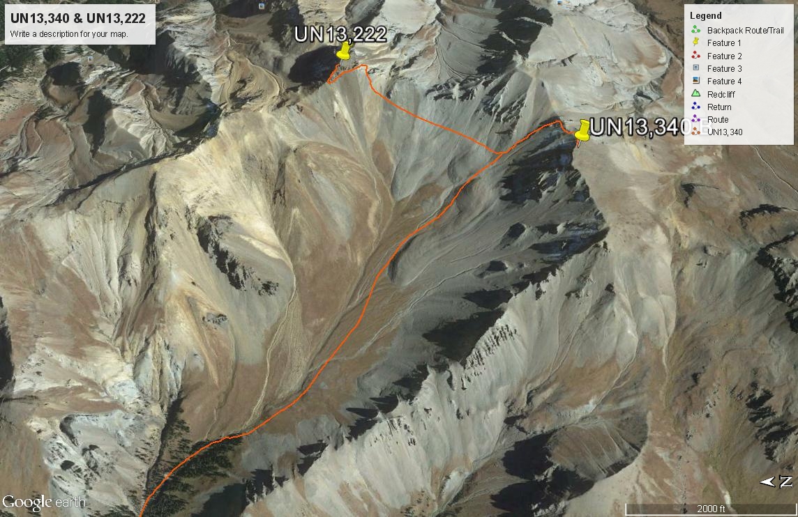
Open This Route in a New WindowFrom the trailhead for Middle Fork Cimarron, walk south up the trail for the two plus miles to the crossing of the creek coming out of Porphyry Basin. Locate a well used trail on the north side of the creek that leads into the upper Porphyry Basin. This trail begins by climbing steeply for a short while, then more gradually as it makes a very long switchback to the north before turning south and bringing you back to the drainage at about the 11,200 ft. contour. Then the trail climbs more gently, coming to a fork in the drainage at 11,400 ft. Across the creek to the south and up on a hillside is a small cabin that appeared to be in use back in 2005. We walked over to it and investigated a little before crossing back over the creek and heading on up valley. Shortly above the cabin, the valley opens up and you'll leave the last trees. This upper basin stretches for about a mile. It is a beautiful, tundra filled basin that earlier in the season would be rife with wildflowers. The most interesting thing we saw in this basin was one lone buck who spotting us, tore off back down the valley and never stopped until he was out of our site.
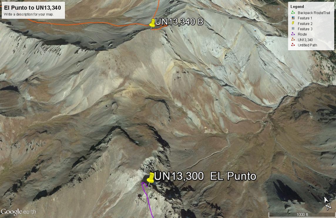
As the basin gradually turns more easterly, begin veering south, heading for a saddle between the east and west summits of UN 13,350. This elevation is an interpolated one. The east summit shows an elevation on the survey map of 13,315 ft. The west summit has no elevation on the map, but the contours indicate it must be at least 13,320 ft. As we headed for the saddle, we were able to follow some tundra for a while, but eventually had to enter the shallow gully and begin scrambling up the scree and dirt on poor footing. We had to negotiate about 600 vertical feet of this stuff and as we approached the saddle, it became very difficult to maintain footing. At the saddle, a difficult section along the ridge compelled us to contour on the north side through the head of another steep gully and climb further up. This last scramble up was even worse for footing, requiring us a couple of times to use our ice axes plunged into the dirt to secure our feet. But once on the ridge again, it was easy walking on up to the summit and only required a few more minutes. The summit is composed of a lot of large, flat, brittle rocks and there was a cairn. To the south, you can clearly see El Punto. From this summit over to it would be an easy walk, but it appeared that gaining the summit from the north side would be a difficult feat. Adding UN13,340 to an El Punto day would be easier than coming up Porphyry Basin as our route has you do.
Descend as you came (on the scree this would be a fast one) or consider contouring over and bagging UN13,222 as well. It would make little sense to leave that one hanging, but it won't be easy.
Click thumbnail to view full-size photo + captionRoute Description
Year Climbed: 2005In our trip, we combined UN13,350 with UN13,220. Therefore the mileage & elevation estimate from 13,220 are based on having first completed 13,350 and then the following route over to 13,220. Most of the account below is from our personal records.
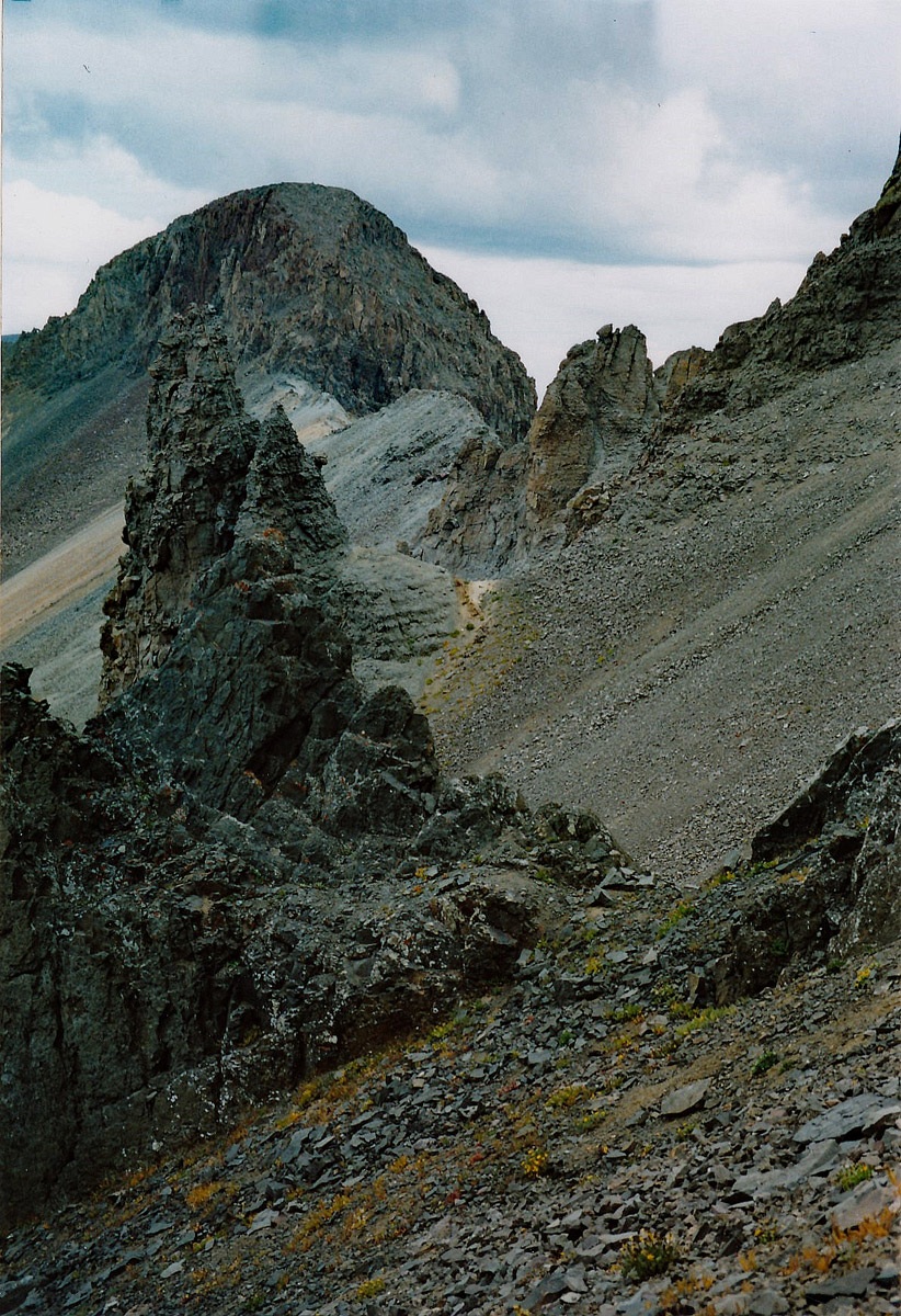
From the saddle east of the true summit of UN13,350, you may wish to tag the 13,315 summit and then proceed along the connecting ridge to 13,220. We did not take that ridge because of threatening weather. So, we decided to lose the elevation and began a plunge-step descent in the scree back down the ascent couloir we had used for 13,350 for about 500 feet until things leveled out a little. Then we contoured for a little while before heading back up to a saddle just south of the 13,220. The task of gaining the next saddle was difficult because it was mostly over slickened, medium -sized boulders for quite a distance. As we approached the saddle, the boulders relented some. We then walked along the ridge north, past one minor point and to the base of the cliffs of the 13,220 summit block. From a vantage point further away, we had spotted what appeared to be a possible route from this side up through the cliffs to a steep slope up above that would lead to the summit. So we explored up a steep, narrow gully that led up for about 50 feet and then ended abruptly. Above the gully, it appeared we could advance a little further, but beyond there, all we could see was a near vertical rock wall that would require technical ascent and gear. Because of the on and off rain and very dark clouds approaching from the south, we knew there would not be enough time to mount a technical ascent, so we decided to retreat back down the gully and contour at the base of the west cliffs across the face of the summit block to the north ridge. (Note: if using Google Earth, it does a very poor job of representing this summit block area.)
This slightly descending contour was across extremely loose and unstable scree. If we had been gaining altitude, it would have been very difficult. Even gradually descending, it was hard enough. After about 15 minutes of struggling across, we turned back up a steep slope of scree, using the aid of a small outcrop of rock for an occasional hand hold to assist and shortly gained the ridge north of the summit block. We proceeded along the ridge toward the summit. In a short distance, we came to the summit block. The route we followed is too complicated to describe, but for the most part, we followed along the ridge, working both sides, and doing a series of 3rd (perhaps 4th class) moves to ascend. The route took us across the head of a precipitous couloir on the northeast side, across ledges and up other short chimneys, etc. for nearly 200 vertical feet. On the wet rock, we had to be extra careful. We were so concentrated on the route, that we never really noticed the exposure. Had it been a nicer day, and had we not been so aware of the oncoming storm and the need to get to the top as rapidly as possible, we might have been more intimidated. But we made the entire ascent without aid or protection. Near the summit, things leveled off and amid rumbles of thunder nearby, we raced to the summit cairn, tagged it, took a quick look around and headed back down. This was no place to be in a thunderstorm, and we wanted to get off the summit block before the rocks became wetter from a serious rain. For another account of this NW ridge, see the link provided to a report by "Furthermore" on ListsofJohn.
As we headed back down, we were able to follow our ascent route closely, even though there was not time on the ascent to make many mental notes as to exactly how we ascended. We did take note of three small cairns on the way up and those three helped to guide us down. Hoping as we descended for the serious rain to hold off for a little longer, we hastily made our way back to the more level ridge and then began a descent on the scree, straight down into the basin west of the summit. Within another 15 minutes, we were out of the scree and onto the tundra. Another 20 minutes got us back to the cabin. From here, you can pick up the trail that accesses Porphyry basin and descend back to the Middle Fork trail and return to the trailhead.
Additional BETA
Links to other information, routes & trip reports for this peak that may be helpful.ListsofJohn › UN 13,222 -