LoJ: #146 (Pre-LiDAR #154) / 13,702' UN 13702 Formerly UN 13,688 B
Peak Summary
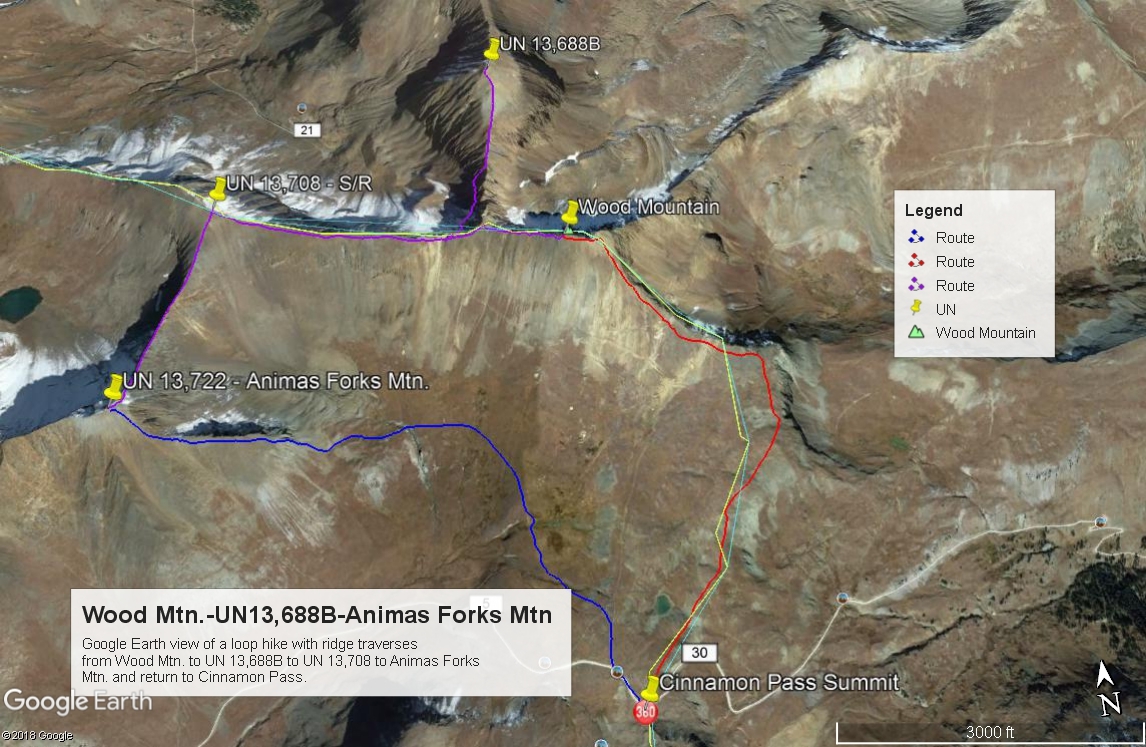
UN13,702 (South Gravel Mtn. and previously measured at 13,688) is part of a three-summit sequence with a 4th, soft-ranked summit thrown in for an easy circuit hike atop Cinnamon Pass. The other summits are Wood Mtn., UN13,708 and UN 13,722 (Animas Forks Mtn.). Reaching UN13,702 from the main ridge that connects all these summits requires going off on a north running spur ridge that requires 3rd class scrambling on pitiful rock. If you're bringing the kids, let them sit this one out unless we're talking about teenagers with some experience under their belt. The Cinnamon Pass trailhead can be reached from the east or the west side by 4WD with good clearance. If you don't have such, you'll be doing a lot more walking or hitchhiking.
UN13,702 South Ridge Route
-
-
Cinnamon Pass TH
From Lake City, proceed south on HWY 149 and take the turnoff to the right for Lake San Cristobal. Continue south around the lake and follow CR3 (BLM 3306) past the Williams Creek and Mill Creek campgrounds to the intersection at Sherman. (On Trails Illustrated, this is CR30) Road to here is drivable for standard passenger cars. Take the right fork and begin a steeper ascent into the upper valley. Higher clearance vehicles now advisable. It's a little over 3 miles to the Silver Creek/Grizzly Gulch trail heads used for accessing Sunshine, Redcloud and Handies. Continue just about one more mile to the trailhead for Cooper Creek. If you're doing the series of 13ers that run NE from Wood Mtn. to Cooper Lake, there is some parking on the west side just after crossing the creek or continue a little further to these coordinates (N 37° 56' 37.57" W 107° 28' 18.36") for another parking spot and the beginning of an old roadbed that leads north, then east to gain a bench above Cooper Creek. Drop one vehicle here if you're able to do a two-vehicle setup, then continue driving on to the summit of Cinnamon Pass. After the turnoff for American Basin, the road begins to climb more steeply and becomes rougher. Park at the summit of the pass or in some other nearby turnouts.
If coming from the Town of Silverton, drive east to where the paved road splits one block past the courthouse and veer right onto blue-signed County Road 2 (set odometer here) for 4.2 miles of nicely graded dirt road to Howardsville. (On Trails Illustrated map #141, this road is labeled #110. Pavement ends after 2 miles.) From the Howardsville intersection, continue north another 4.3 miles to the old site of Eureka. The road will cross to the west side of the Animas River and continue up a steeper shelf section. From Eureka, continue another 3.5 miles to the turnoff for Burns and Grouse Gulch and then a final 1.1 mile farther north to the signed Cinnamon Pass turnoff on the right. Just before this intersection, be careful not to veer off to the left onto the more inviting road up California Gulch. To get to the Cinnamon Pass turnoff, you must continue on the road that would take you to Engineer Pass.
Camping
On the Lake City side, there are designated, forest service campgrounds at Williams Creek and Mill Creek CG. There's also some primitive sites around Sherman. Once above Sherman, additional primitive sites may be found at the TH for Sunshine, Redcloud and Handies and again near the TH for Cooper Creek. You may even be able to find some other primitive sites or just road pull-outs further up the road past Cooper Creek and up into American Basin, but be aware of some private property issues.
On the Silverton side, there are at-large spots heading up the Animas out of Silverton, including some large areas taken over by RV's. Be careful about private property which is all through this area. Up the Cinnamon Pass road , there's really not any good camping, though you could probably vehicle or small tent camp at the pass itself. There are no trees along the drive up from the turnoff.
-
From Wood Mountain
Click thumbnail to view full-size photo + caption
Open This Route in a New WindowWood Mountain is sequenced with UN13,694 (South Gravel) and UN13,740 (Animas Forks Mtn.) for a three summit day. From the top of Cinnamon Pass, walk NNE along the mostly tundra-covered and flower-laden ridge crest, passing a small pond on the left not long after you start. At about 13,000 ft., the ridge turns abruptly to the west. About 50 feet in elevation below the ridge, you can avoid some rock by following an old mining road NW towards a higher point on the ridge.
Alternately, from Cinnamon Pass, there is an old mining road that heads off to the north and passes the same pond mentioned before on it's west side. At about 12,700 ft., you can veer off the old track onto a fainter track that heads off to the right and up the tundra. This track will also intersect the route above near Wood's east ridge at 13,000 ft.
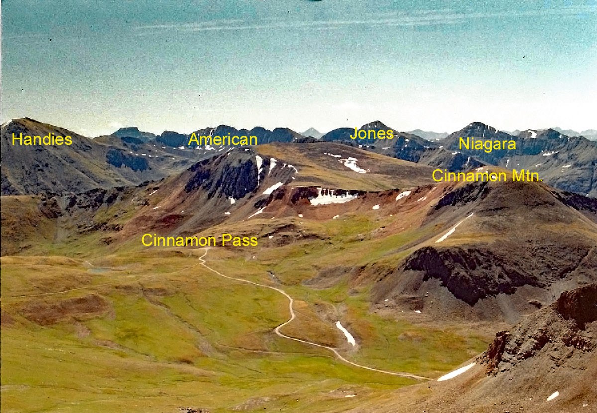
Once on the higher east-west running ridge, hike west on mostly scree/small rock with some low, sparse tundra to the easy summit. If you leave out UN13,688B, the circuit hike around to Animas Forks Mtn. stays at Class 2 and would remain a fairly good family hike perhaps at a three-star level. The view from Wood and any of these peaks here offers an expansive scenic of the surrounding San Juan range. Handies will be the most prominent summit to the east.
Click thumbnail to view full-size photo + captionRoute Description
Year Climbed: 1993UN13,702 (South Gravel Mtn., previously measured at 13,688) is the second peak of a three-summit sequence that also includes a soft-rank summit as well. One-way mileage and elevation gain are measured from the summit of Wood Mountain. Round-trip mileage and elevation gain assume completion of the circuit. The route description described below is basically that proposed in G&M and followed by us.
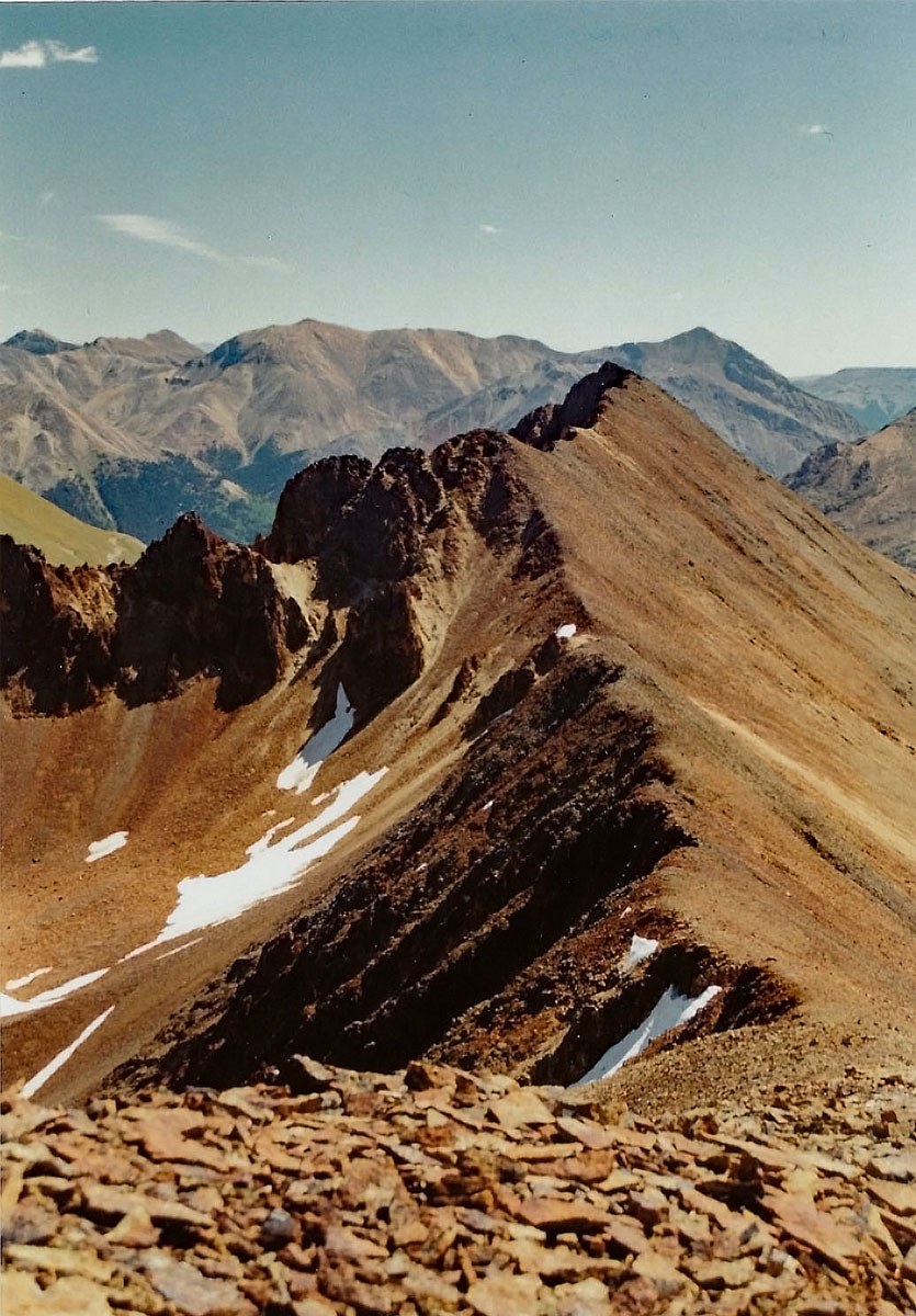
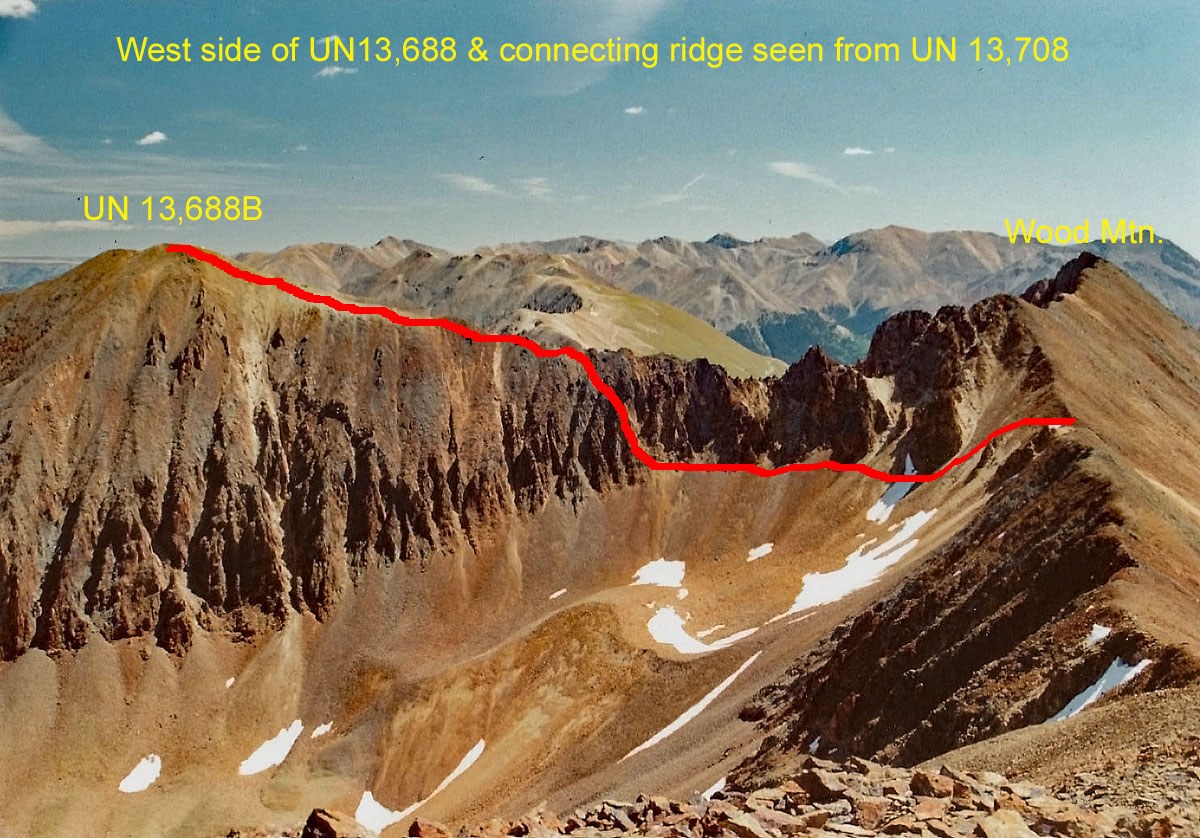
From the summit of Wood Mountain, walk west along the ridge crest on larger, broken rock. In a quarter mile you will come to where the connecting ridge to UN13,702 breaks off at 13,540 ft. The view of the ridge is rather intimidating with all kinds of cliffs on either side and rock spires. The suggested route will be on the west side of that ridge, so continue your westward descent to a saddle at 13,300 ft. Before beginning the traverse, see if you can identify a third couloir that will bring you back up to the ridge just beyond the last major difficulty. That couloir is what to aim for, however, identifying it from below is more difficult. By now, we suspect the route is fairly well established and cairn-marked. On the west side of the ridge, all of the cliffs tend to terminate at about the same level. We found the easiest going to be right at the base of those cliffs, rather than descend farther down into the talus which is very loose and unstable. The upper bowl of Hurricane Basin is nothing more than an unstable talus field. Descend north from the 13,300 foot saddle into the head of Hurricane Basin losing as much as 200 feet, then begin contouring north at the base of the cliffs passing the first two main couloirs. In about 15 minutes you should arrive at the base of the third couloir. The earlier you are in the season, the more likely you will find a large snowfield in the upper basin that can expedite the traverse. Bring an ice axe. Clamber up the steep rock covered with a lot of small gravel, broken rock and sand. It's moderately exposed and my feel 4th class to some, but you should be able to navigate the re-ascent of nearly 200 feet back up to the ridge in 10 minutes or so. If climbing earlier in the season, this will likely be snow-filled and would require ice-axe and crampons. Even though we were climbing this around Labor Day, there were still evidences of snow and ice.
Once back on the main ridge, it's a more simple walk to the summit on much more stable rock. When you arrive, you may want to consider going an additional third of a mile north to the named summit of Gravel Mountain. The round trip will take about 20 minutes each way. Either summit offers nice views of the Engineer Pass road far below at Rose Cabin and the American Flats area to the NW. To continue on with the sequence, basically retrace your route over as best you can, descending that same 3rd couloir, traversing below the cliffs at the head of the talus, then scamper back up to the saddle at 13,300 ft. Head for UN13,708. Brian Kalet has a good report on this peak with a useful photo showing the location of the 3rd couloir. Follow this link: https://www.sites.google.com/s...
Additional BETA
Links to other information, routes & trip reports for this peak that may be helpful. -