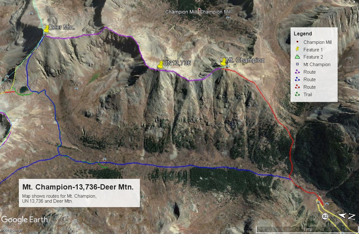
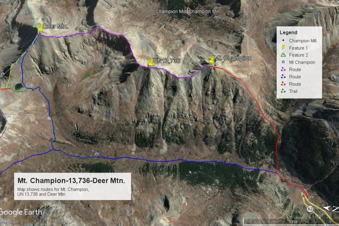
LoJ: #135 (Pre-LiDAR #133) / 13,738' UN 13738 (Formerly UN 13,736)

Peak Summary
UN 13,738 (formerly UN 13,736) is located on a long ridge between Mt. Champion and Deer Mountain, in the headwaters of the North Fork of Lake Creek near Independence Pass. The trailhead is accessible to passenger cars but a few potholes may force some careful navigation. We have sequenced UN 13,738 with Mt. Champion and Deer Mtn. for a longer day that spends a lot of time on a high ridge. Parts of the hike include a stiff, Class 2 uphill hike.
UN 13,738 South Ridge Route
-
-
North Fork Lake Creek TH
From Aspen, drive east on SH82 over the summit of Independence Pass and continue down the east side of the pass to the last switchback where the highway drops into the North Lake Creek valley. Just below the last switchback, there's a turnoff to the left (east) that's a short dirt road that leads to trailhead parking for several vehicles in 100 yards or so. This is just under 5 miles from the summit of the pass. The trailhead parking has a wood rail fence. The short drive in may have some potholes.
If coming from the Front Range, turn west from US24 onto SH82 and drive west past Twin Lakes, continuing up along the Lake Fork until the highway makes the first switchback to begin the climb up Independence Pass. Just before that switchback, turn right (east) onto the dirt road that leads to the trailhead parking in 100 yards or so. This measures about 18.5 miles from US24/SH82 turnoff.
Camping
Camping at the trailhead parking area is not good. If you can get your vehicle across the creek here, there's a faded track that leads up to a primitive site in some trees. Otherwise, there are designated National Forest campgrounds at Parry Peak and Twin Peaks campgrounds back towards Twin Lakes. We recommend a primitive site that has numerous camping possibilities about 2.4 miles back south on SH82 from the trailhead where a diversion tunnel empties water into the Lake Creek at these coordinates: N 39° 04' 54.99" W 106° 32' 21.86". We call this the Graham Gulch TH and it's 16.1 miles from US24/SH82. About a half mile north of there is another smaller area on the west side of the highway at these coordinates: N 39° 05' 15.72" W 106° 32' 32.28".
Measuring from the US24/SH82 intersection, the Whitaker CG is 5.3 miles; Town of Twin Lakes is 6.1; Willis Gulch TH is 8.1; Parry Peak CG is 8.7; Twin Peaks is 9.4; La Plata Peak TH is 14.0.
Campsite Locations
Graham Gulch › N 39° 04' 54.99", W 106° 32' 21.86"
-
From Mount Champion
Click thumbnail to view full-size photo + caption
Open This Route in a New WindowWe have sequenced Mt. Champion with UN13,736 and Deer Mountain on a long ridge connect. Combining these three summits makes for a longer and more difficult day, hence the "Long Day/Back for Dinner" rating. The only real problem with climbing Champion is the initial start and heading up Lackawanna Gulch. This initial start is the same as we have for K49 (UN13,535). Our route described here is best suited for West Slope hikers, but the trailhead access for Front Range hikers, involves probably a little more driving time than taking the long dirt road up Halfmoon Creek out of Leadville.
From the trailhead, walk north on the old roadbed a few hundred yards and find a place to ford the creek. Once across, follow an old jeep track north into a clearing with some old mine tailings. Locate a trail that continues north, then turns east climbing into the trees. This trail continues well-defined (as of 1989) up into Lackawanna Gulch. Eventually, it fades in the higher meadows as you approach timberline. Bill Middlebrook on 14ers.com refers to a more ill-defined trail here. This may be the same as we have described, but what we found was never sketchy at the time. The main point is to work your way east, up through forest and staying on the north side of the main creek in Lackawanna Gulch. It's probably best to avoid the temptation to head directly up the SW ridge of Champion. Continue along and above the creek to about 11,300 feet in elevation where trees begin to thin. Turn more to a NE heading and begin hiking much more steeply up the south slopes of Champion. It is not necessary to continue east up Lackawanna Gulch until the stream forks, but you can if you find using the trail easier.
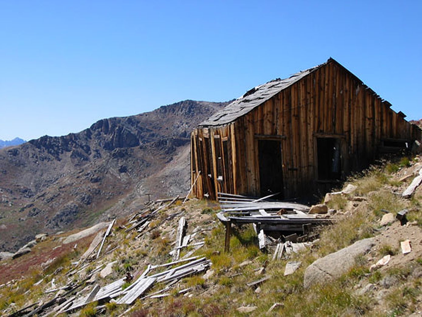
Once you depart the trees, heading north up the steepening south slope, the remainder of the hike is uneventful. The ground coverage is mostly tundra/grass for quite a ways before getting into more scree/rock, etc. Pass the old Champion Mine at about 12,900 feet. At about 13,500 feet, you'll intercept the SE ridge coming in from the right. Continue north along the main ridge to the summit and an impressive view gazing down into the North Fork of Lake Creek, now 2,000 feet below.
For the descent, return as you came. For the more determined peakbaggers, continue north from Champion and begin the trek to UN13,736 and Deer Mtn. The next couple hours of hiking will be a ridge type "skywalk" with impressive views on either side.
Route Description
Year Climbed: 1989UN 13,738 is the second summit in a sequence that begins with Mt. Champion and finishes with Deer Mtn. One-way mileage and elevation gain are measured from the summit of Mt. Champion. Round-trip mileage and elevation gain assume completion of the sequence.
From the summit of Mt. Champion, descend NNW down the ridge to the saddle between Mt. Champion and UN 13,738 on mostly low tundra and smaller rubble. Continue north along the same ridge passing over some rockier sections, but still remaining a Class 2 hike. The ridge returns to low tundra higher up until you reach the false and true summit. These are rockier with some blocks and boulders to scramble around. This section of the three-summit sequence will go quickly and easily in comparison to what comes next. Again, enjoy the views down into Halfmoon Creek on the east and the North Fork of Lake Creek on the west. The scenery is very typical of the Sawatch.
Additional BETA
Links to other information, routes & trip reports for this peak that may be helpful. -