#90 / 13,838' UN 13838 Formerly UN 13,832
Peak Summary
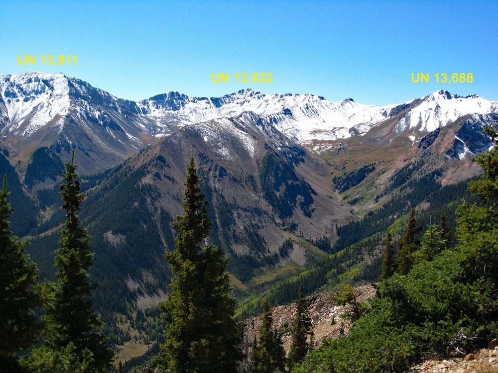
UN 13,832, along with UN 13,811 are two Top 100 summits that are often overlooked by climbers who are more interested in the nearby 14ers, Sunshine and Redcloud. Both 13,832 & 13,811 are easy Class 2 summits. The route covers a lot of high tundra with only minor rock, talus, or rubble to deal with. The Silver Creek Trailhead out of Lake City can be reached by many passenger vehicles, carefully driven, but something with a little higher clearance is preferable.
UN 13,832 West Ridge Route
-
-
Grizzly Gulch - Silver Ck TH
From Lake City, proceed south on HWY 149 and take the turnoff to the right (south) for Lake San Cristobal a little over 2 miles out of town and after gaining some elevation. Continue south around the lake on the west side and follow CR3 (BLM 3306; CR30 on Trails Illustrated #141) past the Williams Creek, then the Mill Creek (13.2 miles from Lake City) campgrounds to the road intersection at Sherman. (1.2 miles past the Mill Creek CG) Road to here is passable for standard passenger cars. Take the right fork (known as the Cinnamon Pass Road) and begin a steeper ascent into the upper valley. Higher/better-than-average clearance vehicles now advisable. It's a little over 4 miles to the Silver Creek/Grizzly Gulch trail heads used for accessing Sunshine, Redcloud and Handies. From Lake City, it's about 18.5 miles overall and requires the better part of an hour to make the drive. On the weekends, park wherever you can find a place to squeeze in. There is a small parking area on the north side of the road, and the trail for Sunshine/Redcloud begins from the lot. A vault toilet is on the south side of the road with the trail taking off from behind the toilet and a footbridge takes you over the Lake Fork to access Grizzly Gulch and Handies Peak.
Camping
On the east side of Lake San Cristobal, there are two designated campgrounds. South of the lake, there are two more campgrounds: the Williams Creek and the Mill Creek. These typically fill on the weekends. After Mill Creek CG, there are no more designated campgrounds, but there are other at-large, primitive opportunities. Turn off toward Sherman and you may find a spot or two as you drive toward the Cataract Gulch TH. If you continue on up road 3306 to the trailhead for Grizzly Gulch and Silver Creek, some people camp right at the TH parking or on nearby spots, and there are more at-large spots further up the road, but be careful about private property.
Click thumbnail to view full-size photo + captionRoute Description
Year Climbed: 1991The route for UN 13,832 begins at the Silver Creek TH. This is the trail most commonly used for hiking to the 14ers, Sunshine and Redcloud. Head northeast on the trail up Silver Creek which stay on the west/north side of the creek and well above it. In about 1.7 mile the trail for the South Fork of Silver Creek turns off to the right. Ignore that and continue NE another 1.2 mile where the trail will turn more to the east in open tundra terrain. Follow the trail for another mile through more open tundra and then switchbacks to climb more steeply to a saddle at 13,020. This is how most will approach Redlcloud Peak, the route for which heads due SW from this saddle.
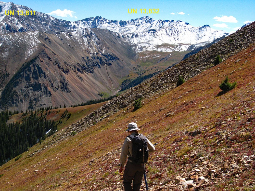
For UN 13,832, at the same saddle, turn left and follow the ridge NE to Pt. 13,561 on tundra, then more rubble. About 200 feet below reaching Pt. 13,561, the trail fades out as people choose various points at which to traverse across the south face, below the summit and on talus instead of going over it. You'll likely find several possible fainter paths to follow so just generally head in the direction of the saddle immediately east of PT. UN 13,561. As you approach the saddle, more well-defined trail options will again appear. Continue east along the ridge and soon, pass a rocky outcrop by following a trail on the south side of the ridge and below the outcrop. Keep hiking more SE to the summit of UN 13,832 on a mix of mostly low tundra, with some scree and smaller rubble.
An alternate route which may save a little time and mileage is as follows for one section of this hike. Back on the Redcloud trail, a little before it begins the steeper climb to the 13,020 saddle, there is a scree gully which directly east and gains about 1,000 feet to intersect the ridge just south of Pt. 13,561. From there, rejoin the route as described above. Whether you use this will depend on your affinity for scree gullies.
Additional BETA
Links to other information, routes & trip reports for this peak that may be helpful. -