LoJ: #192 (Pre-LiDAR #210) / 13,597' West Apostle
Peak Summary
Often climbed in combination with North Apostle and Ice Mountain. This route description will work as a stand alone summit. A moderate dayhike with some steeper terrain and scrambling near the summit makes for one of the more entertaining Sawatch 13ers. Higher ground clearance vehicle will keep the overall mileage down to a medium dayhike, but the peak can be climbed in a day from Winfield where the main road is passable to most all passenger vehicles. Pre-Lidar elevation was 13,568. 29 feet in elevation were added.
West Apostle North Face Route
-
-
Clear Creek/Winfield/Apostles TH
From Leadville, drive south a little over 19 miles on HWY 24 to the turnoff for Clear Creek Reservoir (CR390) and head west. The turn is less than 2 miles south of "Granite." From Buena Vista, drive north just under 15 miles to the same turnoff. Drive west on graded dirt road 11.7 miles to Winfield. As the road approaches Winfield, it will become a little more narrow and likely to have some potholes. Because of heavy use, this road is often washboarded badly. At Winfield, turn south and cross the creek and continue south, then SW on CR390.2B. About 100 yards after crossing the creek, passenger cars may want to park because the road greatly deteriorates beyond there. Higher clearance vehicles may continue. 4WD is not really required for the remainder of the drive to the end of the road. At a little over .7 mile after crossing Clear Creek, just south of Winfield is the turnoff for the blocked road to Lulu Gulch, UN 13,462 A and Browns Peak. From Winfield it's about 2.25 miles to the end of the road and some limited parking. This trailhead is used for both Huron Peak and routes to the Apostles.
If using this general trailhead description for access to peaks up the Lake Fork of Clear Creek (Clohesy Lake), then do not drive all the way to Winfield. Instead, you'll need to turn left at 9.8 miles in from US24 and drive down through the few cabins that comprise "Rockdale," ford Clear Creek and drive to the Clohesy Lake trailhead with a starting elevation of 10,900 ft. 4WD required for this access, otherwise, walk it and enjoy the frigid and sometimes dangerous crossing of Clear Creek.
Camping
For the access to Huron and the Apostles, best camping opportunities are along the final two miles to the trailhead from Winfield. There are several at-large spots available. Camping before Winfield can be difficult because of private property and the large number of people coming to climb Belford, Oxford and Missouri.
There are good campsites for backpackers in the vicinity of "Hamilton" along the Huron Route and the trail up toward the Apostles. There are also good campsites in the meadow just north of the rock glacier at about 11,400 feet or a little lower.
If heading up the Lake Fork toward Clohesy Lake, there is at-large camping at the trailhead which is at a large, open meadow area that's relatively flat. Coordinates are: N 38° 57' 15.48" W 106° 24' 32.64"
-
From Clear Creek/Winfield/Apostles TH via Meadow @ 11,360
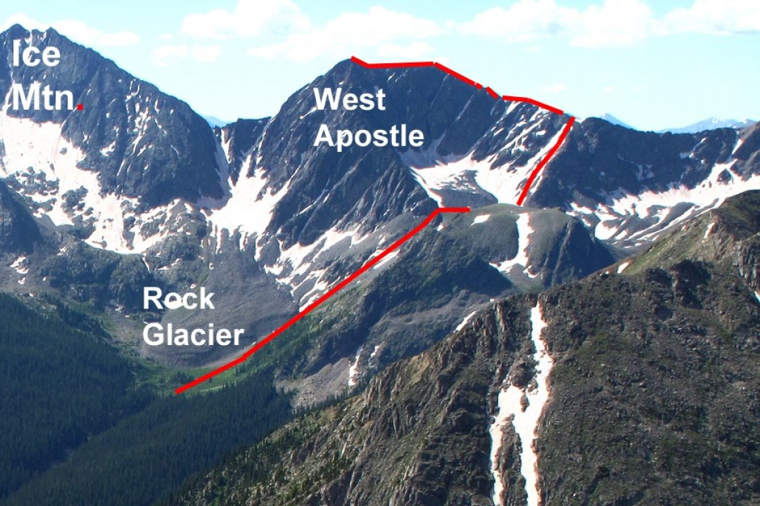
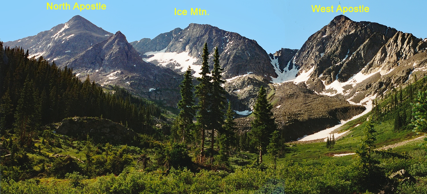
From the trailhead, walk south along the old roadbed. The Three Apostles will loom over the southern horizon and you'll be able to clearly see them. At about 1.25 miles, the main trail begins to turn SE and is a well-used descent route for hikers coming off Huron. Where the USGS map shows the old townsite of "Hamilton," and the trail turns off for Lake Ann, go about another 1,000 ft. and watch for a trail that breaks off the main and continues south crossing an eastern fork of South Clear Creek that drains the south side of Huron, and then crossing the south fork. This trail that breaks off is well-used and continues south through forest gaining elevation along a ridge on the west side of that south fork of South Clear Creek. The trail delivers you to a flat meadow area with abundant wildflowers at 11,360. West Apostle will be directly south. You should be standing near the foot of a vast rock glacier that comes down from the steep couloirs of Ice Mountain and West Apostle. This meadow is where climbers will break off to the SE for North Apostle and Ice Mountain. A use trail will lead to the basin between North Apostle and Ice Mtn.
Camping
Though this climb is usually done as a dayhike, if you want to pack in a ways, primitive campsites can be found near the Hamilton townsite and further south.
Open This Approach in a New Window
Route Description
Year Climbed: 1999At the meadow at 11,360 ft., you'll be standing at the foot of a vast rock glacier. Skirt the foot of the rock glacier and clinging to the west side of the meadow, follow the more western drainage as it heads south and southwest and gains steeply toward a small tarn 12,340 ft. You'll have willows and marshy areas to avoid as you head up. Ever steepening tundra slopes will give way to rock/talus as you approach the small lake. In earlier season, some snow may aid your climb. A prominent ridge that drops north from the west ridge of the peak to this tarn can provide access to the west ridge. Just to the east side of that north ridge are two parallel, shallow gullies, which merge near the bottom into one large snowfield in earlier season. Use either of these two gullies to gain the west ridge. Ice axe is useful if they are full of snow.
Once on the west ridge, turn left (east) and continue up on tundra ledges with embedded rocks that form ledges and shelves.(If you've brought along an ice axe, you may want to ditch it somewhere along here.) As you approach the summit, you'll encounter one false summit which is protected by a minor cliff band. Locate a way through and scramble on up to finish on a near cat-walk like section of ridge leading to the summit. Some light scrambling on this final section will make the climb more entertaining. Admire the rugged and complicated west side of Ice Mtn. return by the same route. If the parallel gullies have snow, enjoy a great glissade down. Round trip time appx. 6 - 7 hours.
-