LoJ: #180 (Pre-LiDAR #182) / 13,628' White Dome
Peak Summary
White Dome NNW Ridge Route
-
-
Bear Creek/Hunchback Pass/Kite Lake TH
WARNING: This trail head approach REQUIRES 4WD with good ground clearance. The drive as described below from Silverton may take up to 2.5 hours.
From the Town of Silverton, and where the main road splits at the NE end of town, drive 4.2 miles NE up along the Animas River on blue-signed County Road 2 to Howardsville. Turn right onto FR589 up Cunningham Gulch and stay right at the turn for the "Old Mine Tour" (4.4 miles) but do take the left fork toward Stony Pass (FR737) at 5.9miles. Once on the Stony Pass Road, expect 4W conditions. The road climbs steeply to the pass. Abundant wildflowers as you approach the pass may delay you. Once across the pass, the road becomes FR520 and eventually leads to Rio Grande Reservoir, but you will not drive that far. The road eventually descends down the valley to a low water crossing of Pole Creek. There are several primitive campsites on both sides of the Pole Creek crossing. Watch out for the steep embankment climb out on the east side if the road is wet from rains. You could easily slip off the edge. After the crossing, continue south for under a mile to another fork where you'll turn right (west). Another long, low water crossing is found here across the Rio Grande River. This crossing is usually more shallow than the Pole Creek, but the closer you are to runoff season, the more difficult these crossings will be.
It is also possible to come into this area from either Creede or Lake City over Slumgullion and Spring Pass to Rio Grande Reservoir. From state highway 149 either about 20.5 miles from Creede or 32 miles from Lake City, turn west onto FS520 and drive all the way to the reservoir on the well-signed, graded dirt road. Passenger cars can make it all the way to the "Lost Trail Campground" at the far west end of the reservoir. Beyond that point, FR520 continues west and crosses some rugged sections before connecting with the other section of FR520 coming down from Stony Pass and the low-water crossing of the Rio Grande. We have never driven in all the way on this section and from those we know who have, they have complained about one particularly difficult stretch.
From the Rio Grande crossing, continue up what is now, the Beartown Road for a slow 4 miles (mainly because of potholes) to the former location of Beartown. (There's really nothing left to see there, but just before the road crosses Bear Creek, beyond the old townsite, there is some good camping. The road goes all the way to Kite Lake at about 12,100 ft., but the Hunchback Pass trailhead is about 1/2 mile below the lake. There's a trail sign there and some very limited parking is available. Road Notes as of 2018: About half the distance toward Beartown, the road crosses an unnamed creek and at that spot, there are some difficult mud/potholes that have really been dug out. Longer bed vehicles may have some difficulty getting through. Take it slow. Closer to Beartown, the road passes through a fence line. At that point, the road conditions will begin to deteriorate and become more rocky as it begins to gain some elevation.
As the road begins climbing more steeply toward Kite Lake and the Hunchback trailhead, after crossing Bear Creek, it becomes quite a bit more rocky in that stretch as well. For a long section, the road is deeply entrenched in the middle because of runoff and the trench tends to fill with loose rocks. If you have driven in here to do the Ute Ridge group of summits, camp in the vicinity of where the road crosses Bear Creek just past the old Beartown site. See coordinates below. From that creek crossing, it's not quite .3 mile to the trailhead for Ute Ridge, which is a jeep track that turns off to the left and drops down to cross another lesser fork of Bear Creek. Park somewhere along this track if heading for Ute Ridge. On the Caltopo map, this trail is called the "Bear Town Trail" and designated FR869. On trails Illustrated Map #140, it does not appear to have a designation. Coordinates for this road & trailhead are: N 37° 42' 54.53" W 107° 30' 35.00". You can find a good camp spot here as well. You can also find some additional camp spots within a few hundred yards of the Hunchback Pass trailhead. One of those spots goes off to the south to an old mining area.
Camping
You can find some very limited camping spots in the immediate vicinity of the Hunchback trailhead. There's one particularly good spot back down the road a fairly short distance on the south side. There's also some good camping back toward the Beartown site. See coordinates provided.
Campsite Locations
Beartown Campsite › N 37° 43' 05.02", W 107° 30' 35.47"
Route Description
Year Climbed: 1993White Dome combines well with Peaks One, Two and Three for a full day of hiking from Kite Lake. Since that's how we did it, this route description for White Dome begins from Kite Lake, but we continued on to Peak One, then Three and Two. Consult those peaks for more details. From the trailhead for Hunchback Pass, you'll need to either drive or walk the remaining half mile to Kite Lake. If driving, this last portion of road will be the roughest. Mileage estimates and total elevation gain provided include going over White Dome, following the ridge SW to Peak One, then heading west to Peak Three. Also included in the estimate is continuing on to Peak Two and then returning to Kite Lake.
There are actually four possible approaches to these peaks. Three of those would involve a backpack trip of several days. The first backpack approach would be to hike in from Molas Lake down to Elk Park and up the Elk Creek/Colorado Trail to Eldorado Lake for a base camp. The second approach would still be from Molas Lake and up Elk Creek, but would turn off at the beaver ponds and head up into Vestal Basin. From the head of Vestal Basin, you could pack over "Trinity Pass" to Trinity Lake for another base camp and could climb White Dome and Peaks One, Two and Three from that location. The third approach could be in from the Highland Mary Lakes or the end of the road in Cunningham Gulch out of Silverton. Passenger cars can make it to a trailhead there where you could either pack up to the lakes and then connect from Verde Lake over to the Continental Divide/Colorado Trail which leads south to Kite Lake, or skip the lakes and hike up directly from the trailhead to the Continental Divide/Colorado Trail and follow to Kite Lake. This third option may be the shortest and easiest backpack option for White Dome and Peaks One, Two and Three. The best map to see all this on is the National Geographic/Trails Illustrated #140, "Weminuche Wilderness." Driving in from either Silverton over Stony Pass and then on to "Beartown" & Kite Lake or up from Rio Grande Reservoir and then "Beartown" to Kite Lake is the only plausible way to do this group as a "day hike."
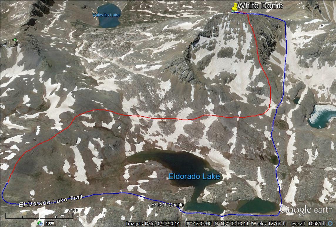
From Kite Lake, hike up a trail that leads east to a pass just south of Pt.12,924 and then drops to Eldorado Lake. At the top of the pass, to avoid losing elevation, walk south along the ridge crest on a trail that will probably fade out, then turn west and cross below the north face of White Dome on something of a bench that's about 100 - 200 feet above the lake. Head for the NNW ridge of White Dome that plays out at some tarns and a small, unnamed lake NW, below White Dome. As you cross to the NNW ridge, you'll cross several rocky stretches, and in early season, you can expect snowfields. Once on the ridge, it will mostly all broken, medium-sized rocks among ledges and shelves. Footing will generally be secure. 900 feet of not-too-steep gain should bring you out a little west of the summit. Stroll on over and enjoy the overview of the uniquely colored Eldorado Lake. This lake sees a lot of backpacking visitors. Campsites abound all around it. From Kite Lake to the summit will be under two hours.
If doing White Dome alone, for the descent, return by the same route or walk along the ridge crest to the west and drop to a saddle, then turn north and head down a rock-filled bowl (may provide a nice snow glissade earlier season) toward the unnamed lake at 12,540 ft., but before reaching that lake, follow a drainage past some small tarns NNE to the west end of Eldorado Lake. Walk around the north shore of the lake and connect with a trail back to the pass that separates Eldorado and Kite Lakes. Complete the rocky trail back to your vehicle. If continuing on to Peak One, see that route description for details.
-