LoJ: #425 (Pre-LiDAR #423) / 13,271' Wildhorse Peak
Peak Summary
Though Wildhorse Peak has a somewhat formidable appearance, it remains as a simple Class 2 hike thanks to an easy route through the rock formations as you approach the summit. Shortest approach to this summit is from Engineer Pass, which can be accessed from either Silverton or Lake City. A 4WD with good ground clearance is very useful for reaching our suggested trailhead from either direction, though if coming from Lake City, it may be possible to get there with a higher clearance 2WD vehicle. The peak offers a spectacular summit with cliffs that plunge off in almost all directions and stands out prominently from amid all the vast tundra terrain. It would also make a great deal of sense to include Blackwall Mtn. with a hike to Wildhorse, even though that will add at least another three miles. Pre-Lidar elevation was 13,266 ft.
Wildhorse Peak SE Ridge Route
-
-
American Flats TH
There are two main access routes for the summits located around Engineer Pass and American Flats; one from Lake City, the other from Silverton.
These directions begin from Lake City. From Gunnison, go west on SH50 to the intersection near the beginning of Blue Mesa Reservoir with SH149 and turn south. From Montrose, drive east on SH50 to the east end of Blue Mesa Reservoir for the same turnoff on SH149. Drive west and south on 149 to Lake City, just over 45 miles from the previous intersection. Once in Lake City, watch for either 3rd or 2nd street. Turning west on either will take you to Bluff St. in two blocks and a left turn (south). 2nd St. is considered the "official" access to CR20 which heads west following Henson Creek, but if you take 3rd St., it passes by a nice city park with restroom and picnic tables for those who need a break before proceeding further.
Once on CR20, drive 9.1 miles west to Capitol City on a graded, gravel road passable to passenger vehicles. On the Gunnison National Forest map, this road is labelled as BLM3303. At 5.2 miles into this drive, you'll pass the Nellie Creek Road (FR877) which accesses Uncompahgre Peak and several 13ers located in that area. At Capitol City take the left fork which is the "Alpine Loop Road" that will lead over Engineer Pass, but you won't be driving quite that far. This is the continuation of BLM3303. On Google Earth, this is still CR20. Continue driving west past the "Rose Cabin" on the old USGS map. (Note: About 1500 feet east of the Rose Cabin is a solar powered vault toilet on the south side of the road, frequently used by visitors to this area.) From that vault toilet pullout, it's about another 3.6 miles west (appx.) to our suggested parking spot and trailhead for American Flats, which is nothing more than a pullout at the coordinates provided. The main goal is to locate the start of the trial that heads north across American Flats and park off the road enough to avoid blocking the frequent 4WD, ATV and ORV traffic. If you come to a beautiful log cabin perched on an overlook of the valley with a foot bridge leading over the creek to the cabin, then you still have another 1.75 miles. The parking is above treeline.
From Silverton: From the Town of Silverton, drive east on the main road through town to where the paved road splits one block past the courthouse and veer right onto the blue-signed County Road 2 (set odometer here) for 4.2 miles of nicely graded dirt road to Howardsville. (On Trails Illustrated map #141, this road is labeled #110. Pavement ends after 2 miles. This road is also known as "The Alpine Loop Road and BLM 4500.) From the Howardsville intersection, continue north another 4.3 miles to the old site of Eureka. The road will cross to the west side of the Animas River and continue up a steeper shelf section. The road begins to get a little more difficult and enters a more narrow section of the Animas River canyon. At about 10,740 ft., the valley begins to widen out again. In that location, another road heads off to the left for Picayne Gulch. It is possible to reach UN 13,075 and Hanson Peak by going up this way, but the lower section of this road is intensely steep, so only for lower gear ratio 4WD vehicles. For the American Flats TH, stay on CR2 and follow directions & road signs to Engineer Pass. This will REQUIRE 4WD. The 4WD track circles the west side of Engineer Mountain, crosses the pass and then begins its descent toward the upper reaches of Henson Creek. When you reach the summit of Engineer Pass, the proposed trailhead is only about 1,600 feet east of the pass.
Camping
There are several primitive sites to choose from all along CR20 when coming from Lake City, all the way up to our proposed trailhead, however, there are no National Forest campgrounds. At Capitol City, there is some limited camping there, but there's also private cabins & property so exercise some discretion and this area can be very popular on weekends. At the vault toilet near Rose Cabin, if you drive a short distance on a road there past the toilet, there's room for a couple vehicles. Just after Rose Cabin, where the main road veers right, there's a CR20X that stays down closer to the creek. There are several good primitive sites in there, but again, be aware of private claims. The only "facility" in all this area is the vault toilet at the coordinates provided below.
If coming from Silverton: There are no official Forest Service campgrounds in the upper Animas River valley and summer weekends can see a swarm of campers in this overall area. Something of an "RV" village tends to build up at a large flat area along the river opposite the Maggie Gulch turnoff and then at the ghost town of Eureka, there's a number of campsites east of the river. The best campsites we have found are along the spur road that leads to the trailhead for the South Fork of the Animas, aka: The"Boulder Gulch" trailhead. The road that heads into there has several primitive sites. One could also just camp at the switchback for the trailhead to Bonita. This location is open with no trees for shelter. None of these locations have facilities of any kind. Lastly, we spotted some reasonable sites in Picayne Gulch. If you turn off the main Alpine Loop Road where the Picayne Gulch Road first comes in a couple miles south of Animas Forks and drive up the CR9, there will be a branch road that heads off and climbs a ridge with trees on the south side of the gulch. Eventually that road rejoins the main Picayne Gulch Road at a switchback at 11,800 ft. We noticed some campsites along this spur road in the trees before it rejoins the main road.
Campsite Locations
Vault Toilet › N 37° 58' 34.23", W 107° 32' 03.52"Elevation 10,850 ft.
Click thumbnail to view full-size photo + captionRoute Description
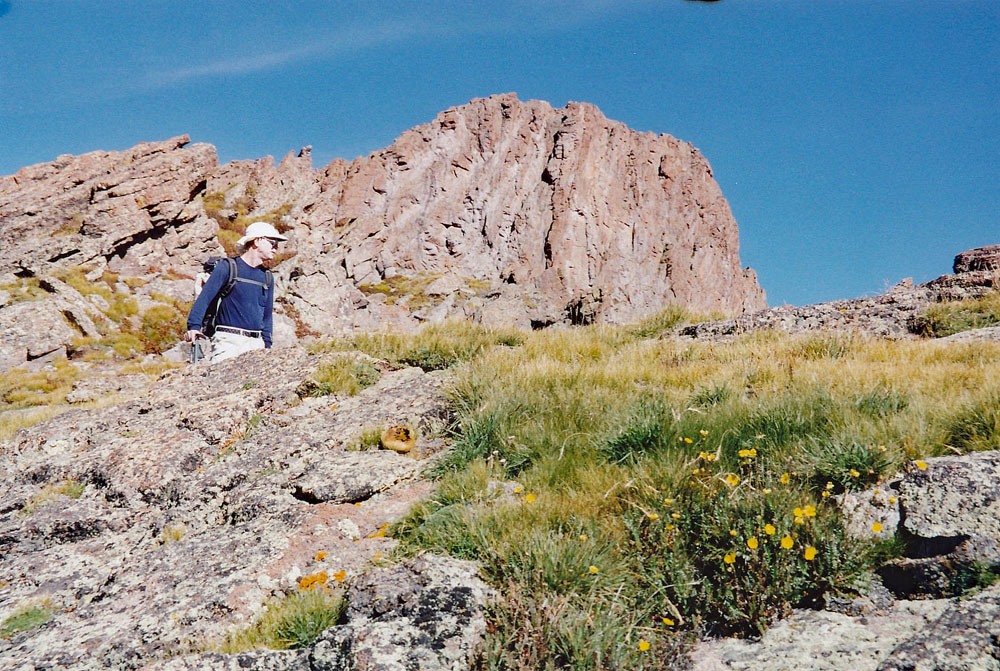
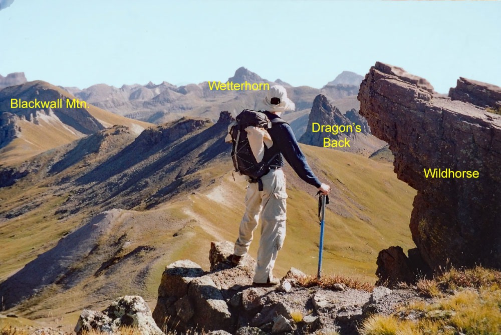
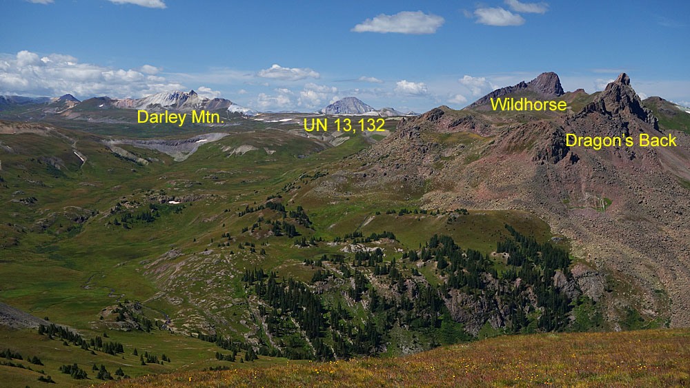
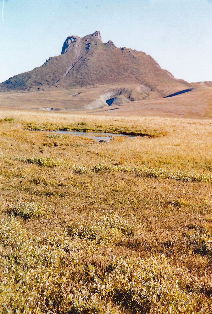
Year Climbed: 2006The trailhead information we provide should place hikers near the beginning of an old roadbed/trail that heads out north across American Flats beginning just a short distance east of Engineer Pass. This is on the Handies quad. The roadbed/trail shows on both the 1955 Handies quad and the FSTopo 2016 map version. Once you locate the proper trail, follow it generally north. This is easy tundra hiking for over three miles. We would suspect that this trail is primarily used to bring in a large herd of sheep that graze in this area every summer. As a result, wildflowers are not quite as good as other locations but still present. The trail basically contours with minor variations in elevation all the way to a saddle at 12,300 ft., located at the very bottom of the Wetterhorn quad. In the distance, Wildhorse Peak will grab your attention - a fairly dramatic looking tooth that juts up out of the surrounding tundra. From the saddle, hike across more tundra to the NE, gaining a broad tundra ridge where you may find as we did, a very large herd of domestic sheep grazing. The herd is guarded by large, white dogs, probably Great Pyrenees variety. Just mind your own business and they should not give you any trouble. Do not make sudden moves or do anything to threaten the sheep and the dogs should leave you alone. There may or may not be a shepherd around.
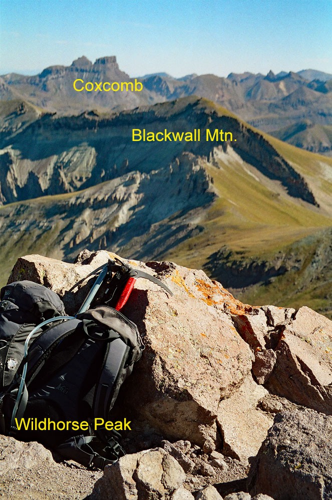
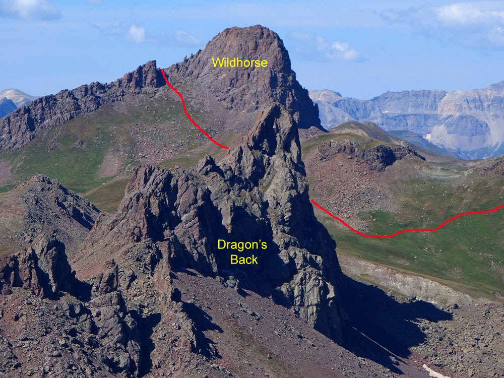
The broad tundra ridge will deliver you to the south side of Wildhorse where looking, up there will be the formidable looking summit, a little over 600 feet up. As we began ascending, we found numerous sheep trails and their droppings, and probably a human usage trail that followed close to the southeast ridge. This trail leads up through the tundra and onto more gravel and rock, but other than a steep ascent, it is easy hiking. The last 200 feet give way to a hodgepodge of more rock outcrops and there is a short scramble along the summit ridge to reach the true summit. I think we arrived here in about 2 hours from the start. From the rocky outlook summit, you can peer over the north edge of the peak and see the precipitous drop-off that is so prominent when viewed from across Wetterhorn Basin, or you can gaze into the headwaters of Wildhorse Creek with topography very similar to the Cimarron Forks. Once you've enjoyed the scenic summit, either return as you came or continue to Blackwall Mtn.
Additional BETA
Links to other information, routes & trip reports for this peak that may be helpful. -