LoJ: Not Ranked / 13,682' Wood Mountain
Peak Summary
Wood Mountain, prior to the application of LIDAR technology, was considered a ranked summit coming in at #169 with an elevation of 13,660 ft. It has now been classified as unranked with a new elevation of 13,682 ft., and a prominence of 295 feet.
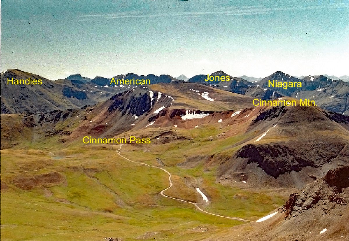
Wood Mountain is the first in a sequence of three ranked summits located north and NW of Cinnamon Pass. Wood Mtn. itself is a Class 1+ tundra hike but completing the circuit of peaks will get you into some 3rd class work to access UN13,694, aka: South Gravel. Access to this circuit is from the top of Cinnamon pass so a 4WD with good clearance is highly advised and reduces walking time considerably. The route may be accessed from out of Silverton by way of the road north up the Animas River toward Engineer Pass, or out of Lake City by taking the road to Cinnamon Pass, which also gives access to the 14ers Redloud, Sunshine and Handies. There are numerous 13ers located in this area so plan plenty of time to visit some of the other summits. Careful planning can result in bagging multiple summits in a day.
Wood Mountain SE Ridge Route
-
-
Cinnamon Pass TH
From Lake City, proceed south on HWY 149 and take the turnoff to the right for Lake San Cristobal. Continue south around the lake and follow CR3 (BLM 3306) past the Williams Creek and Mill Creek campgrounds to the intersection at Sherman. (On Trails Illustrated, this is CR30) Road to here is drivable for standard passenger cars. Take the right fork and begin a steeper ascent into the upper valley. Higher clearance vehicles now advisable. It's a little over 3 miles to the Silver Creek/Grizzly Gulch trail heads used for accessing Sunshine, Redcloud and Handies. Continue just about one more mile to the trailhead for Cooper Creek. If you're doing the series of 13ers that run NE from Wood Mtn. to Cooper Lake, there is some parking on the west side just after crossing the creek or continue a little further to these coordinates (N 37° 56' 37.57" W 107° 28' 18.36") for another parking spot and the beginning of an old roadbed that leads north, then east to gain a bench above Cooper Creek. Drop one vehicle here if you're able to do a two-vehicle setup, then continue driving on to the summit of Cinnamon Pass. After the turnoff for American Basin, the road begins to climb more steeply and becomes rougher. Park at the summit of the pass or in some other nearby turnouts.
If coming from the Town of Silverton, drive east to where the paved road splits one block past the courthouse and veer right onto blue-signed County Road 2 (set odometer here) for 4.2 miles of nicely graded dirt road to Howardsville. (On Trails Illustrated map #141, this road is labeled #110. Pavement ends after 2 miles.) From the Howardsville intersection, continue north another 4.3 miles to the old site of Eureka. The road will cross to the west side of the Animas River and continue up a steeper shelf section. From Eureka, continue another 3.5 miles to the turnoff for Burns and Grouse Gulch and then a final 1.1 mile farther north to the signed Cinnamon Pass turnoff on the right. Just before this intersection, be careful not to veer off to the left onto the more inviting road up California Gulch. To get to the Cinnamon Pass turnoff, you must continue on the road that would take you to Engineer Pass.
Camping
On the Lake City side, there are designated, forest service campgrounds at Williams Creek and Mill Creek CG. There's also some primitive sites around Sherman. Once above Sherman, additional primitive sites may be found at the TH for Sunshine, Redcloud and Handies and again near the TH for Cooper Creek. You may even be able to find some other primitive sites or just road pull-outs further up the road past Cooper Creek and up into American Basin, but be aware of some private property issues.
On the Silverton side, there are at-large spots heading up the Animas out of Silverton, including some large areas taken over by RV's. Be careful about private property which is all through this area. Up the Cinnamon Pass road , there's really not any good camping, though you could probably vehicle or small tent camp at the pass itself. There are no trees along the drive up from the turnoff.
Click thumbnail to view full-size photo + captionRoute Description
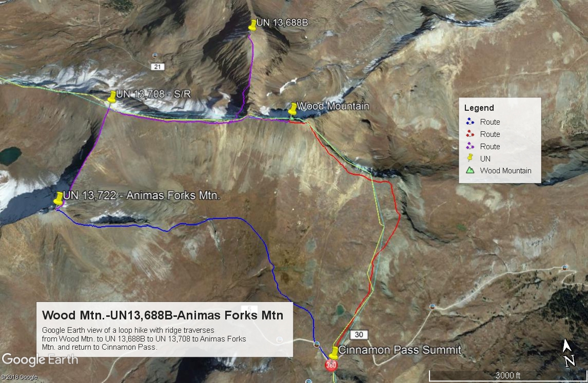
Year Climbed: 1993Wood Mountain is sequenced with UN13,694 (South Gravel) and UN13,740 (Animas Forks Mtn.) for a three summit day. From the top of Cinnamon Pass, walk NNE along the mostly tundra-covered and flower-laden ridge crest, passing a small pond on the left not long after you start. At about 13,000 ft., the ridge turns abruptly to the west. About 50 feet in elevation below the ridge, you can avoid some rock by following an old mining road NW towards a higher point on the ridge.
Alternately, from Cinnamon Pass, there is an old mining road that heads off to the north and passes the same pond mentioned before on it's west side. At about 12,700 ft., you can veer off the old track onto a fainter track that heads off to the right and up the tundra. This track will also intersect the route above near Wood's east ridge at 13,000 ft.
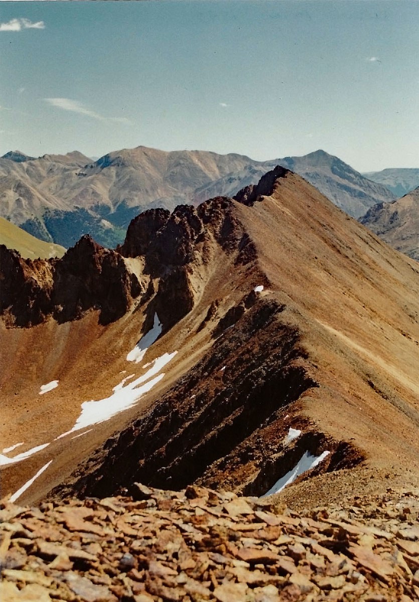
Once on the higher east-west running ridge, hike west on mostly scree/small rock with some low, sparse tundra to the easy summit. If you leave out UN13,688B, the circuit hike around to Animas Forks Mtn. stays at Class 2 and would remain a fairly good family hike perhaps at a three-star level. The view from Wood and any of these peaks here offers an expansive scenic of the surrounding San Juan range. Handies will be the most prominent summit to the east.
Additional BETA
Links to other information, routes & trip reports for this peak that may be helpful. -