LoJ: #69 (Pre-LiDAR #71) / 13,916' Emerald Peak
Peak Summary
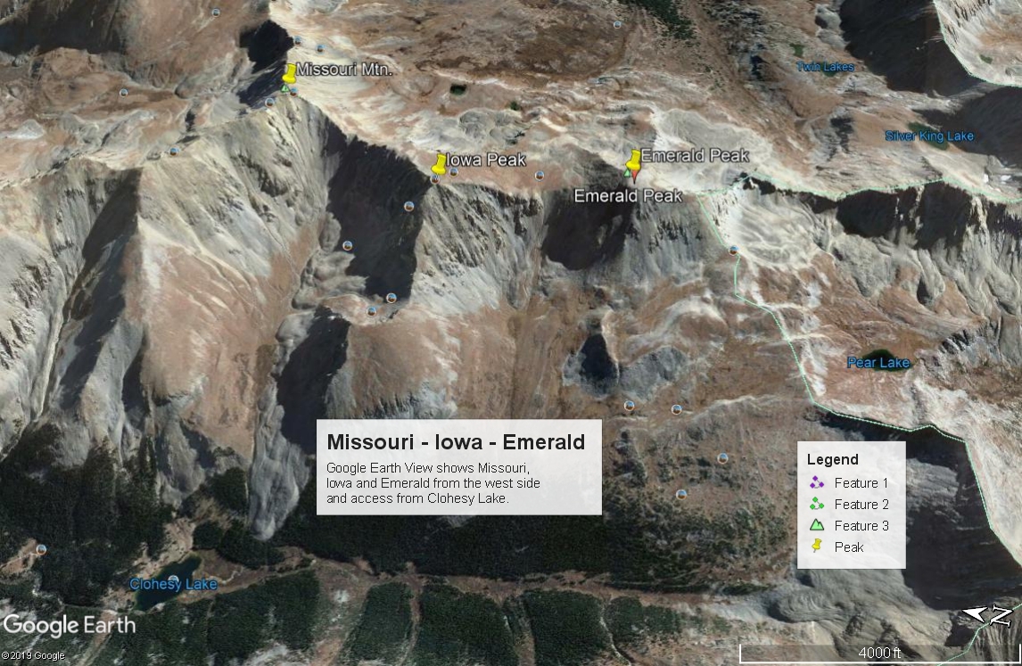
Emerald Peak is a Class 2 hike from the trailhead north of Clohesy Lake. From this start, the 8.5 mile loop hike can be easily completed in a day and will include the unranked Iowa Peak. A side trip to Missouri Mountain is also possible without adding much more elevation gain or distance. The only drawback is reaching the trailhead north of Clohesy Lake. This requires a 4WD or very good high clearance vehicle. Without access to such transportation, the hike would have to begin from near the creek crossing below Rockdale. This would add another 6 miles round-trip plus a wade across Clear Creek.
Emerald may also be combined with a trip up Missouri Gulch from Vicksburg and going over the summit of Missouri before continuing on to Emerald. This route will not be discussed here. 4WD would not be required for this access.
A third option is to backpack in along Pine Creek. This route covers 13.2 miles one-way. It would still be a Class 2 climb as the other possibilities. We will provide some detail about this access as an alternate for those who perhaps want to climb Harvard from Pine Creek along with Emerald. 4WD would not be required for this access.
Emerald Peak via Pine Ck. Route

-
-
Pine Creek TH
From Leadville, take US 24 south past the turnoff for Twin Lakes/Aspen (CO82) and continue to the turnoff on the right (west) for CR390 that provides access to Clear Creek Reservoir, Vicksburg & Winfield. Continue on US 24 south from this intersection and measure 2.2 miles to another county road #388 that turns off to the right (west.) Turn here. Coordinates are: N 39° 00' 09.70" W 106° 14' 10.90" at 8760 ft. elevation.
From Buena Vista and the main intersection on US 24 and CR306 to Cottonwood Pass, drive north on US 24 between12.9 to 13.0 miles and turn left onto CR388.
Once on CR388, follow the main road south, then SW when it bears left. The road then climbs uphill on 2 wide curves and then straightens out as it continues eastward. Do not turn right at the first opportunity. Drive a little more east to where the road makes a 90° turn right. Follow it south, then it makes another broad turn back to the NE, followed by another broad curve that will eventually have you heading south to the trailhead parking. Do not turn off onto any other roads. All others are private. A higher clearance vehicle will be preferred to reach the trailhead. If in a lower clearance passenger car, you may need to park lower down. From the US24/CR388 intersection, it's between .7 and .8 mile to the trailhead.
Camping
Because of private property, there's really not any good camping at the trailhead. The closest place available is back at the Clear Creek Reservoir where there's camping around the reservoir or west up the road to Vicksburg. Summer weekends can make finding a camp spot difficult. The closest National Forest campgrounds will be back on CO82 around the Twin Lakes area.
-
From Pine Creek TH via Missouri Gulch Trail #1469
The "approach" begins at the Pine Creek Trailhead. On Trails Illustrated, this is Trail #1459, but on the National Forest San Isabel map, this is #1467. The trail passes through private property and there is a requested fee for crossing of $1.00 per person or $2.00 if you have a dog. Usually there are envelopes provided for dropping this into a box. The initial 2 miles tend to be open, hot, dusty and rocky, but the trail is never very steep. In 3.75 the trail comes to the wilderness boundary. A short distance past there it will intersect the Colorado Trail #1776 and cross to the north side of Pine Creek. From the wilderness boundary, it's another 5.7 miles to the Missouri Gulch/aka: Elkhead Pass Trail and about 3 miles to "Little John's Cabin." This area makes a good place to camp, even though there are agreeable places before reaching the now, dilapidated cabins. Emerald & Iowa can be easily done as a day hike from the cabins. Across the creek and south of the cabins is another trail called "The South Pine Creek" Trail #1458 (TI) that leads SE over to Frenchman Creek and eventually Harvard Lakes.
If you want to keep packing in, continue on west and SW on the Pine Creek Trail passing Bedrock Falls, (which can provide a nice refreshing stream dip), followed by the trail emerging into a long meadow filled with willows. The trail stays on the north/west side of the meadow and generally keeps you out of the willows. There are some other camping opportunities along the trail as it passes through this meadow. At about 9.5 miles in from the trailhead is the trail junction that we'll call the end of the "approach." The trail splits and you can either head west, then north toward Elkhead Pass or continue SW to Silver King Lake. The 13er, UN 13,762/aka: Magdalene Pk. is accessible from the vicinity of the lake via a rocky ridge on the east side of the lake.
Camping
Probably the best camp area is in the vicinity of Little John's Cabin. Plenty of room here for larger groups and fishing as well.
Campsite Locations
Little John's Cabin N 38° 57' 18.75, W 106° 18' 56.85"Elevation 10,750 ft.
Open This Approach in a New Window
Route Description
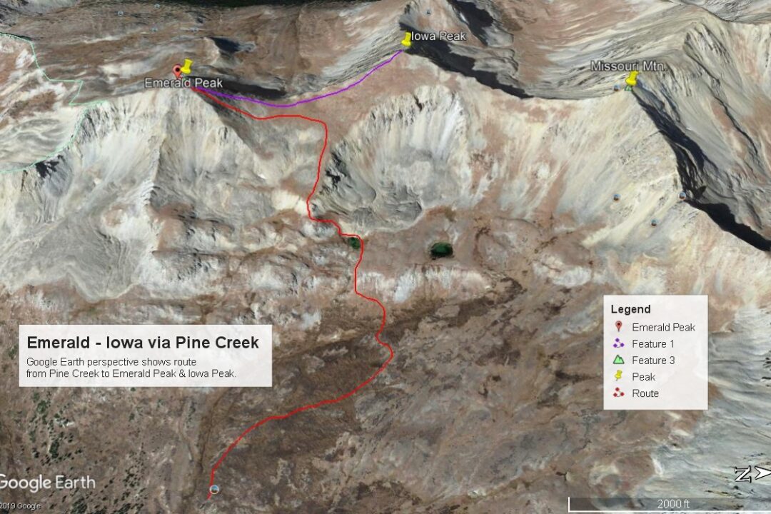
Year Climbed: 1988From the trail intersection for Elkhead Pass & Silver King Lake, proceed up the Elkhead Pass trail as it first heads west, then turns north and follows a broad slope between two tributaries of Pine Creek. At about 12,360 ft., turn west again, departing the trail and contour over to cross the drainage. Once across, continue in a westerly direction passing through willows and ascend on grass/tundra to a bench with a small, unnamed lake a little south of a larger lake at 12,717 ft. From this unnamed lake, head a little SW and follow tundra to a smaller bench area followed by a steeper ascent to reach a broader, sloping plateau that leads to the Emerald-Iowa saddle. The hike to the saddle can be accomplished on almost all tundra except for some brief sections. Once at the Emerald-Iowa saddle, turn south for the Emerald finish. The summit cone is mostly rubble/talus and is the only tedious part of this hike for about 450 vertical feet.
For Iowa, simply hike back down the rubble/talus dome back to the Emerald-Iowa saddle, and then hike on tundra to the summit of unranked Iowa Peak. From there, return back to the same saddle and follow your ascent route back down for the return trip. As mentioned before, Missouri Mtn. could also be easily included on this hike.
Note: We completed this route to Emerald in July of 1988 with monsoonal conditions prevailing the day we climbed. Lightening was a threat on both the ascent & descent. Our rain suits were "buzzing" from the electricity building up and our ice axes delivered a strong static charge just before there was a nearby lightening strike. Needless to say, our memories of this climb are not of fondness for this peak.
Additional BETA
Links to other information, routes & trip reports for this peak that may be helpful. -