LoJ: #189 (Pre-LiDAR #190) / 13,604' Gray Wolf Mountain
Range ›
Front Range
Quadrangle ›
Mount Evans
Summit Location ›
 N 39° 37' 01.76", W 105° 39' 39.14"
(Not Field Checked)
N 39° 37' 01.76", W 105° 39' 39.14"
(Not Field Checked)
Neighboring Peaks ›
Mount Spalding
Mount Warren
Rogers Peak
Peak Summary
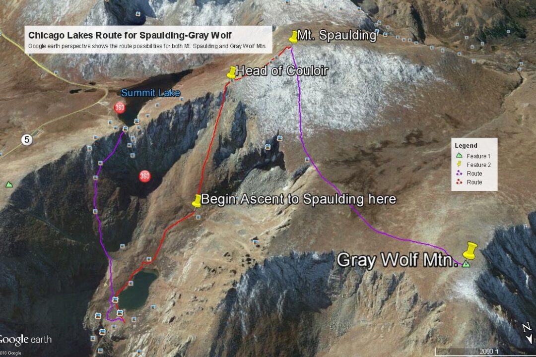
Gray Wolf Mountain is sequenced with Mount Spalding, an unranked 13er north of Mt. Evans. Gray Wolf ranks in the Top 200 summits. From the summit of Mt. Spalding, Gray Wolf is an easy Class 2 stroll across a wide and gentle basin that forms the head of the north fork of Scott Gomer Creek. All three route possibilities we provide for Spalding can lead to a quick trip from Spalding to Gray Wolf. All three routes are passenger car accessible. The route up Chicago Creek is the longest. Pre-Lidar elevation was 13,602.
Gray Wolf South Flank via Chicago Lakes Route
Class 2
Long Day // Back for Dinner
Climbed with
Mount Spalding
RT From Chicago Lakes - Mt. Evans Wilderness:
14.4 mi / 4,640'
RT From
Upper Chicago Lake
with
Mount Spalding:
5.8 mi / 2,660'
From Mount Spalding:
1.40 mi / 580' (One-Way)
-
-
Chicago Lakes - Mt. Evans Wilderness TH
From either Idaho Springs (Exit 240 on I-70) or Bergen Park, (Exit #252 to Evergreen Parkway from westbound I-70, then turn west onto the Squaw Pass Road), drive to Echo Lake on HWY 103 (aka: Squaw Pass Road in Bergen Park). From the Idaho Springs turnoff, it's 13.3 miles. When driven from Bergen Park, this road does a lot of winding around and receives a lot of bicycle traffic in the summer, especially on weekends. A nice bike lane has been added to the older, more narrow portion of the road that has helped to alleviate some of the dangers posed by such a multiple use road.
For parking, we suggest turning onto the Echo Lake picnic area road just NW of the western end of the lake. This road is .6 mile from the SH103/SH5 intersection. The intersection is on the north end of a large parking area just off SH103 which is just north of the lake. The gravel road takes you west, then south a quarter mile to parking. On weekends, arrive early. It is likely the Forest Service has hikers park near the campground to help save parking spaces for day-use picnickers.
Camping
There is a campground located on the east side of the Mt. Evans Road (SH 5) across from the lodge and entrance station. This is a typical National Forest CG with fee required. There are vault toilets and water available. There are 17 sites total with 10 suitable for RV's, but no hookups. The campground is open typically the first week of June through the Labor Day weekend. Reservations can be made during the high season, otherwise it's first-come, first-served. Visit the following link for additional Forest Service information: https://www.fs.usda.gov/recare...
Campsite Locations
Echo Lake CG › N 39° 39' 22.89", W 105° 35' 39.35"Elevation 10,660 ft.
-
From Chicago Lakes - Mt. Evans Wilderness TH via Upper Chicago Lake & Mount Spalding:
-
Mt. Spalding "Windy City" Couloir Class 3 / 1.5 mi / 2,080’ One-Way
Open This Route in a New WindowFrom the trail where it crosses the outlet for the upper Chicago Lake, cross on over the outlet stream to the south side and then work along the SE shore of the lake to the southern end of the lake. The authors ventured up here nearly four decades ago with no specific information regarding what they might find in regards to an exit out of the Chicago Lakes valley. The rugged headwall presents several couloirs as a possible escape. We chose to continue in a SSW direction from the end of the upper lake toward a rounded slope that formed the lower cone of a well-defined couloir that appeared to split near the top. The top of the couloir intersects the Spalding east ridge. Google Earth offers a fairly well-defined view of this slope and how it gives way to the couloir higher up, so we have provided an image to assist in identifying this exit. We believe this is the same couloir that Roach describes in "Colorado's Thirteeners" and has provided the name of "Windy City." The coordinates for the bottom of the rounded slope are: N 39° 36' 26.01 W 105° 38' 44.73", elev. 11,900 ft. This route should top out at these coordinates approximately: N 39° 36' 04.20 W 105° 39' 03.61", elev. 13,460 - 13,500 ft. appx.
Walk steeply up the lower rounded cone of this slope for several hundred feet before you are forced into the couloir. The authors found themselves in the midst of a large group of resting mountain goats who were sunning themselves on the open tundra patches. As you enter the couloir, the terrain changes from mostly tundra and embedded rock to rocky rubble, talus, medium boulders, etc. The scrambling will approach Class 3 if you're here later in the summer. Earlier in the summer, you may find snow and will need ice axe and at a minimum, micro-spikes. Keep at it until you break out of the couloir and onto the east ridge of Spalding, near where the ridge fans out more widely. From there, stroll and trip on to the summit amid mostly boulders & rocks of varying sizes. Return as you came or continue over to Gray Wolf.
Alternate to the Windy City Couloir: From the upper Chicago Lake at the outlet, a trail leads off to the south passing through some willows and gaining a bench on the southeast side of the lake. This trail actually continues steeply up the north flank of Mt. Warren all the way to a point on the west ridge of Mt. Warren about .25 mile east of Summit Lake. You can then just drop down to the Warren/Spalding saddle, then follow the east ridge route to the summit of Spalding (or Warren & Rogers to the east for that matter.) The trail that leads up from the upper lake is not drawn on some maps. The Mt. Evans USGS quad does not show it, neither does the Trails Illustrated map. Nevertheless it is clearly there and is used by many who choose to ascend Mt. Evans by way of Echo Lake, a longer but much more sporting way to climb that 14er.
-
Route Description
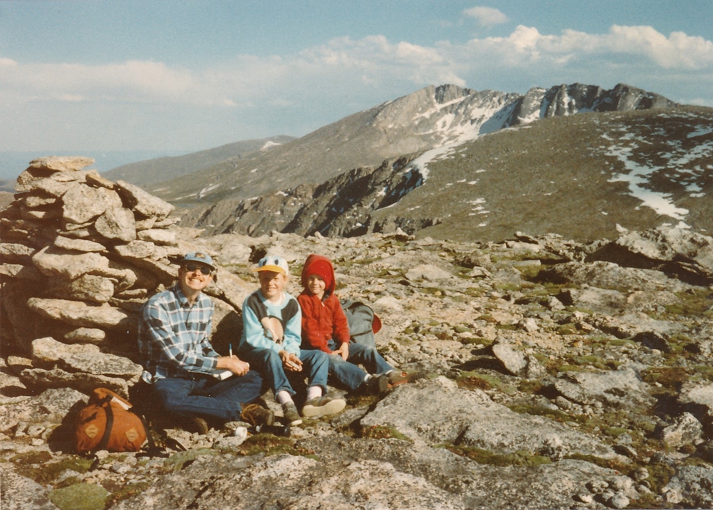
Year Climbed: 1983Gray Wolf Mountain is sequenced with Mt. Spalding. One way mileage and elevation gain are measured from the summit of Spalding. The route you choose to use to access Spalding will influence the overall round-trip mileage and elevation gain when Gray Wolf is included. Please be alert to those differences, however, with all three Spalding routes, the traverse over to Gray Wolf remains the same. From the summit of Spalding, head directly north and downhill to cross the huge "playground" at the head of Scott Gomer Creek that lies between the two summits. Going down Spalding will be the most difficult part, there being mostly very rocky terrain, large boulders & rubble for the initial descent. As you near the Gray Wolf-Spalding saddle, the rock diminishes and the terrain changes over to mostly tundra with embedded rock. A nice relief. Begin your uphill hike from the saddle heading mostly north, then veering a little west to reach the summit which is still mostly tundra with embedded rock.
If you used the Echo Lake-Chicago Lakes approach, the easiest way to return would be by the Spaulding east ridge back down to Summit Lake. From there, go up the Mt. Warren west ridge a little to locate the trail that drops down to the upper Chicago Lake. Follow the steep trail down. Some may want to drop straight down the north slope from Summit Lake toward the upper Chicago Lake. That is a possible but more problematic route. The author did that many years ago with success, but had to explore multiple options created by a number of benches and low cliffs. Use of the trail down is far better. Also, you could descend by way of the "Windy City" couloir (or other couloirs that drop down to the upper Chicago Lake) mentioned by Roach in "Colorado's Thirteeners."
Additional BETA
Links to other information, routes & trip reports for this peak that may be helpful. -

"Tears shed for self are tears of weakness, but tears shed for others are a sign of strength." Billy Graham
Warning!
Climbing peaks can be dangerous! By using this site and the information contained herein, you're agreeing to use common sense, good judgement, and to not hold us liable nor sue us for any reason. Legal Notice & Terms of Use.