LoJ: Not Ranked / 13,863' Mount Spalding
Peak Summary
Mount Spalding is actually an unranked summit north of Mt. Evans that rises less then 300 feet from the saddle that connects it to Evans. Nevertheless, if you're cleaning out 13er summits around Mt. Evans, you'll likely want to go ahead and include Spalding and it's a very short hike from Summit Lake. Since you can drive to Summit Lake in most any passenger vehicle, the short, Class 2 or 2+ hike can be accomplished with no great difficulties. Spalding combines easily with Gray Wolf to the north. In addition, there's a much more interesting and "sporting" route for Spalding/Gray Wolf that involves a hike into a more isolated valley with some beautiful lakes to enjoy and the climb out of that valley can involve at least some brief Class 3 scrambling.
Mt. Spalding "Windy City" Couloir Route
-
-
Chicago Lakes - Mt. Evans Wilderness TH
From either Idaho Springs (Exit 240 on I-70) or Bergen Park, (Exit #252 to Evergreen Parkway from westbound I-70, then turn west onto the Squaw Pass Road), drive to Echo Lake on HWY 103 (aka: Squaw Pass Road in Bergen Park). From the Idaho Springs turnoff, it's 13.3 miles. When driven from Bergen Park, this road does a lot of winding around and receives a lot of bicycle traffic in the summer, especially on weekends. A nice bike lane has been added to the older, more narrow portion of the road that has helped to alleviate some of the dangers posed by such a multiple use road.
For parking, we suggest turning onto the Echo Lake picnic area road just NW of the western end of the lake. This road is .6 mile from the SH103/SH5 intersection. The intersection is on the north end of a large parking area just off SH103 which is just north of the lake. The gravel road takes you west, then south a quarter mile to parking. On weekends, arrive early. It is likely the Forest Service has hikers park near the campground to help save parking spaces for day-use picnickers.
Camping
There is a campground located on the east side of the Mt. Evans Road (SH 5) across from the lodge and entrance station. This is a typical National Forest CG with fee required. There are vault toilets and water available. There are 17 sites total with 10 suitable for RV's, but no hookups. The campground is open typically the first week of June through the Labor Day weekend. Reservations can be made during the high season, otherwise it's first-come, first-served. Visit the following link for additional Forest Service information: https://www.fs.usda.gov/recare...
Campsite Locations
Echo Lake CG › N 39° 39' 22.89", W 105° 35' 39.35"Elevation 10,660 ft.
-
From Chicago Lakes - Mt. Evans Wilderness TH via Upper Chicago Lake
Warning: During the fall rut (mating season) for mountain goats, you may find this trail closed. From the picnic area parking on the west side of Echo Lake, walk south along the lake-shore path to the SW corner of the lake and keep going south to intersect Trail #52. Turn right and begin following the Chicago Lakes Trail #52. The trail more or less contours south for a half mile before reaching the first switchback that begins the series of switchbacks that drop the trail down to Chicago Creek. Elevation loss is about 280 feet. There are some places along this section where the drop-offs are quite steep. When you reach the creek, there's a hewed log bridge to aid in crossing. Cross on over and pick up the old roadbed that heads SSW to Idaho Springs reservoir at 10,617 ft. It's a half mile to the reservoir dam.
Beyond the reservoir, the old roadbed will turn to trail at the Mt. Evans Wilderness Boundary, well marked with signs & registration instructions. As you head into the wilderness, the trail takes you into an old forest fire burn from 1978. This area can have abundant wildflowers in the middle season. The trail will also leave the valley bottom and begin to gain quite a bit of elevation on the north side of the drainage to avoid the willow-clogged creek. As the trail approaches the first lake, it is still climbing through a lot of brush, then begins to make a descent. It is after the beginning of this descent that there will be a trail intersection, where the trail begins to head up again. The left fork will take you down to the lower lake. The right fork will continue to the upper lake.
To reach the upper lake, the trail passes through a steep section that may require some very minor scrambling. While the lower lake is about treeline in elevation, the upper lake at 11,760 ft. is above treeline. Nevertheless, there are still plenty of willows. This "approach" ends where the trail crosses the stream outlet for the upper lake. The upper lake is a very popular backpacking/camping destination. In fact this trail is part of the much longer, but still popular Mt. Evans route. The following link is to a pdf document by the forest service that covers all the trails in the Mt. Evans Wilderness including the Chicago Creek/lakes trail. https://www.fs.usda.gov/Intern...
Camping
See the Echo Lake trailhead information for camping beta at the Echo Lake campground. For wilderness camping at the upper Chicago Lake, the best opportunities appeared to be at the NE end of the lake in the vicinity of the outlet or on an elevated bench above the lake on its' SE side.
Open This Approach in a New Window
Route Description
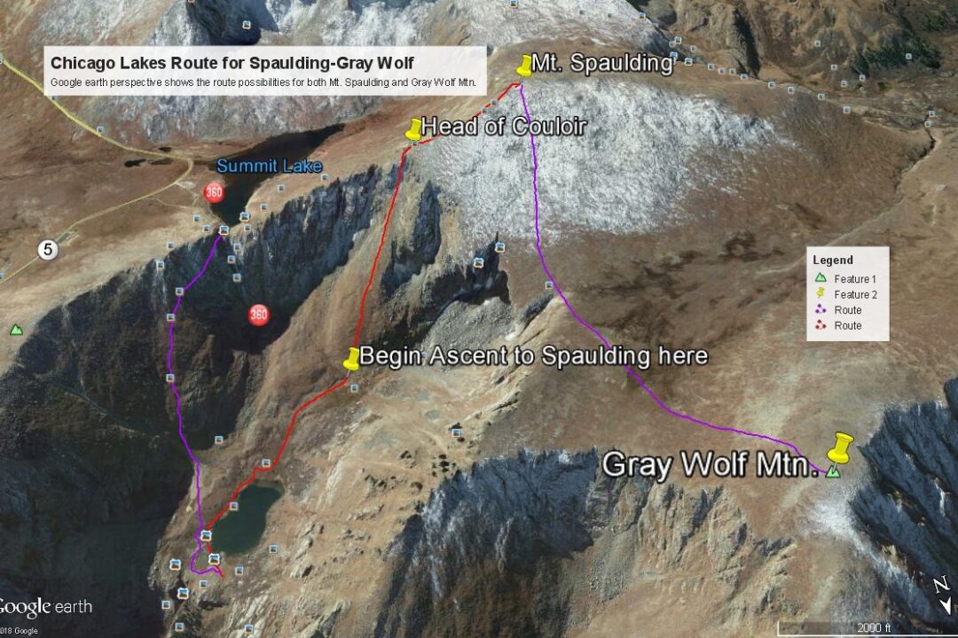
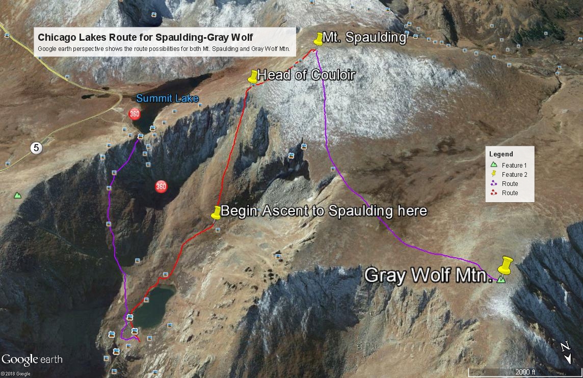
Year Climbed: 1983From the trail where it crosses the outlet for the upper Chicago Lake, cross on over the outlet stream to the south side and then work along the SE shore of the lake to the southern end of the lake. The authors ventured up here nearly four decades ago with no specific information regarding what they might find in regards to an exit out of the Chicago Lakes valley. The rugged headwall presents several couloirs as a possible escape. We chose to continue in a SSW direction from the end of the upper lake toward a rounded slope that formed the lower cone of a well-defined couloir that appeared to split near the top. The top of the couloir intersects the Spalding east ridge. Google Earth offers a fairly well-defined view of this slope and how it gives way to the couloir higher up, so we have provided an image to assist in identifying this exit. We believe this is the same couloir that Roach describes in "Colorado's Thirteeners" and has provided the name of "Windy City." The coordinates for the bottom of the rounded slope are: N 39° 36' 26.01 W 105° 38' 44.73", elev. 11,900 ft. This route should top out at these coordinates approximately: N 39° 36' 04.20 W 105° 39' 03.61", elev. 13,460 - 13,500 ft. appx.
Walk steeply up the lower rounded cone of this slope for several hundred feet before you are forced into the couloir. The authors found themselves in the midst of a large group of resting mountain goats who were sunning themselves on the open tundra patches. As you enter the couloir, the terrain changes from mostly tundra and embedded rock to rocky rubble, talus, medium boulders, etc. The scrambling will approach Class 3 if you're here later in the summer. Earlier in the summer, you may find snow and will need ice axe and at a minimum, micro-spikes. Keep at it until you break out of the couloir and onto the east ridge of Spalding, near where the ridge fans out more widely. From there, stroll and trip on to the summit amid mostly boulders & rocks of varying sizes. Return as you came or continue over to Gray Wolf.
Alternate to the Windy City Couloir: From the upper Chicago Lake at the outlet, a trail leads off to the south passing through some willows and gaining a bench on the southeast side of the lake. This trail actually continues steeply up the north flank of Mt. Warren all the way to a point on the west ridge of Mt. Warren about .25 mile east of Summit Lake. You can then just drop down to the Warren/Spalding saddle, then follow the east ridge route to the summit of Spalding (or Warren & Rogers to the east for that matter.) The trail that leads up from the upper lake is not drawn on some maps. The Mt. Evans USGS quad does not show it, neither does the Trails Illustrated map. Nevertheless it is clearly there and is used by many who choose to ascend Mt. Evans by way of Echo Lake, a longer but much more sporting way to climb that 14er.
Additional BETA
Links to other information, routes & trip reports for this peak that may be helpful. -