LoJ: #71 (Pre-LiDAR #70) / 13,911' Red Mountain
Peak Summary
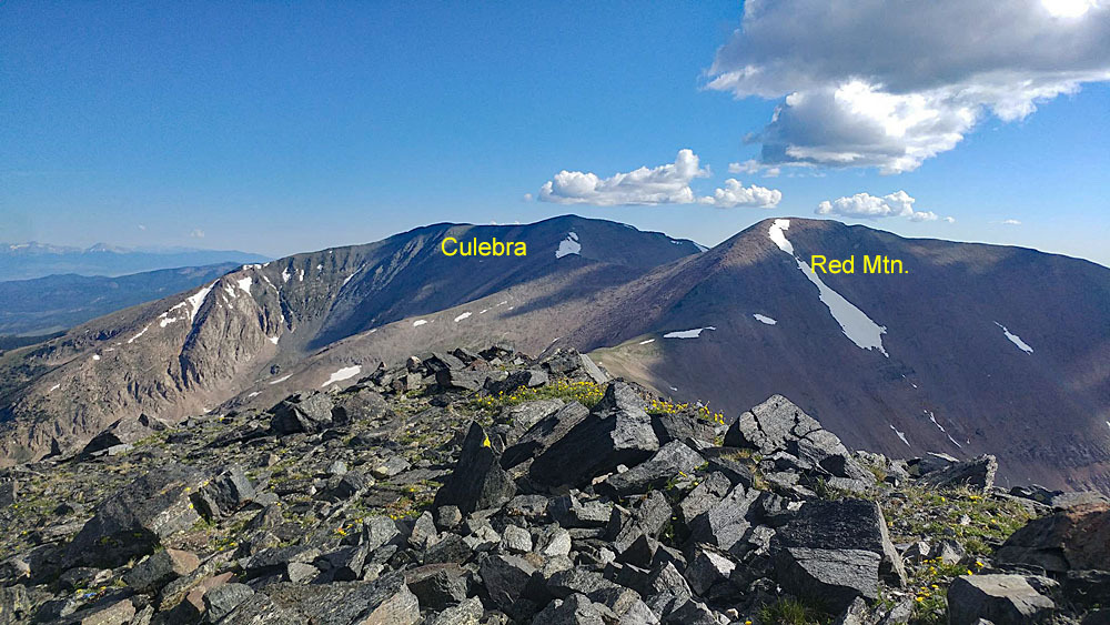
Red Mountain is a summit located a little south of the 14er, Culebra Peak. Both are located on private property, which over the years has made access difficult if not impossible at times. In August of 2017, the property changed hands again. Leading up to that exchange, the ranch was being called the "Cielo Vista Ranch." Before that, most referred to it as the "Taylor Ranch." To reach Red Mountain, most climbers will likely summit Culebra first, then make the short run over to Red Mtn. For what you pay to climb Culebra, if the new owners are allowing access, you may as well climb Red. The hike over from Culebra is a Class 2, rocky, rubbly walk. The "Four-way" trailhead is accessible by passenger vehicles with better than average clearance so some crossover types may be able to make it. The owners state that 4WD or AWD are required to make the Four-way intersection. The upper trailhead, if access is allowed would be better driven in something with higher clearance. Access to these peaks will all depend on the policies of the owner. The following link will provide most of the information you will need: https://www.cielo-vista-ranch.info/product/hiking/
For 2024, the cost of climbing Culebra and Red Mountain together is $150. Reservations must be made in advance as well as payment, online at the link above. Access times are strictly adhered to. No climbers are allowed after the end of July. Pets are NOT ALLOWED. Please follow all rules so that access to these summits can be maintained.
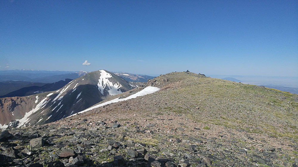
Red Mountain South Ridge Route
-
-
Culebra/Whiskey Pass Accesses - Cielo Vista TH
The Cielo Vista Ranch (translation - "View of Heaven") was previously known as the Taylor Ranch. Total acreage of the property now exceeds 83,000. Be advised that as of August 2017, the ranch property changed hands again and is now under the ownership of William B. Harrison, of William Harrison Cathexis Holdings. Any information provided here may change dramatically depending on any future new ownership. The eastern boundary of the property is the central ridge of the Sangre de Cristo range from De Anza Peak in the north all the way to State Line Peak on the New Mexico border to the south. All of the land on either side of that central ridge is privately owned from Maxwell Mountain on south. Trespassers have been and will be prosecuted. As of the date of this writing, the only property owner allowing access is/was the Cielo Vista Ranch. One newspaper report indicated that the new owner did not plan to change the access policies previously held by the Cielo Vista ranch owners, but there have been some changes that do impact climbers. The property is a virtual wildlife preserve, rich in its diversity, and provides needed resources to the local community.
The main, current website for the ranch is https://www.cielo-vista-ranch.info/product/hiking/. The current site shows a 2024 update. Norton antivirus software wants to block this site as "dangerous." From our personal experience, there appears to be no danger in visiting the site. This is as of 01/2024. Mailing address is: Cielo Vista Ranch; County Road M.5; San Luis, CO 81152. Email contact: [email protected]. Phone: 719-680-0092. (Carlos)
Some items to know up front. Again, these were verified 01/2024:
- There is no climbing allowed from August 1 through the end of December.
- The current fee to climb Culebra/Red Mtn. is $150. For any other summits, it has been reported this season that the fee has increased to $500.
- Winter climbs begin in January with reservations being taken in December.
- Hiking/climbing is allowed only on Friday-Saturday-Sunday.
- A waiver and credit card form must be submitted in advance.
- The gate opens at 6:00 AM and closes at 6:15 AM!
- Sign out is 6:00 PM. Beyond that time, ranch officials will consider your tardiness to warrant a search & rescue situation. You will be instructed to "donate" $100 to the Costilla County SAR.
- Dogs & non-climbers are not allowed.
- Climbing reservations for the 2024 are currently being accepted.
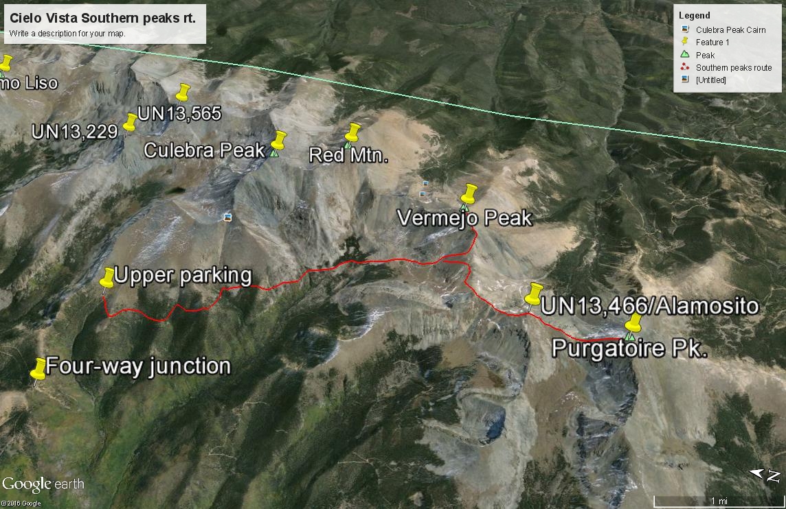
Since all climbers must report to the main ranch headquarters, that location will serve as the main trailhead, however, Whiskey Pass can also serve as a trailhead, after you have registered at ranch headquarters and current policy ALLOWS access from that location. We will divide access as follows: Use the main ranch entrance and the 4WD road up to "four-way" as the TH for Purgatoire, UN13,466, Vermejo, Red Mtn., Culebra, UN13,565, UN13,229 and Miranda. Use Whiskey Pass as the TH for Lomo Liso, Francisco, Beaubien, De Anza and Mariquita. (Note that Mariquita is not actually on CV Ranch property.) We also have a report that indicates some climbers were allowed access up Carneros Creek to climb UN13,229 and UN 13,565. We have no specific information however in regards to that access. Also, for peaks other than Culebra and Red Mountain, Cielo Vista has required climbers to have a hand radio which the ranch supplied. DO NOT ASSUME that current policy allows access to summits other than Culebra and Red. Call or email ahead to obtain additional information.
Driving Directions: From the small town of Ft. Garland, located on HWY 160 east of Alamosa and west of Walsenburg, drive south on HWY159 to San Luis - about 15.5 miles.
Turn left on the P.6 Road (4th street) and drive 4.0 miles to Chama.
In Chama, turn left on L.7 Road.
Drive 3.5 miles on L.7, across a bridge and immediately turn right on dirt Road 25.5. To access Whiskey Pass, you would continue east on L.7.
Go 1/2 mile on 25.5 Road, stop, and turn left on M.5 Road.
Drive another 0.9 miles to reach the North Gate of the Cielo Vista Ranch.
The gates are usually closed and ranch representatives will meet you for an escort to the ranch headquarters.
Once through the north HQ gate, continue 2 miles to the ranch headquarters for check-in.
After check-in, reset your odometer and drive on an easy 4WD road to the upper trailhead. Stay right at about .1 mile and continue driving up the steepening road.
You will reach "Four Way" at 3.4 miles with ample parking, 11,220 ft. N 37° 08' 32.23" W 105° 13' 57.08"
You may be allowed to continue on to the highest point of the road at 4.4 miles. This is the upper trailhead and you may park near a stream. 11,670 ft. N 37° 08' 20.38" W 105° 12' 56.72"The following directions are provided by the Cielo Vista Ranch on their website:
Find San Luis, Colorado. Begin in San Luis, at the Conoco station on main street. You will be driving southbound from Ft. Garland. At the Conoco Station, turn east (left). Drive 3 miles to stop sign. Right turn onto County Road 21. Traveling southbound on CR 21, proceed to County Road L.7. Left turn on L.7, you will be driving eastbound. Continue on CR L.7 to one of several county roads which go south from L.7. (Note that CR L.7 is also the "Whiskey Pass Road.") Each of these short roads will take you to County Road M.5, which parallels L.7, about 200 yards to 500 yards south. Take one is these roads (CR 22.5, 23.5, etc.) south to CR M.5. Left turn on M.5 sends you east. Continue east on M.5 until you reach the large heavy green steel gate, which is the entrance to the North headquarters of Cielo Vista Ranch. Watch for local dogs which are roaming the streets and county roads in the area, at will!
To get to the Whiskey Pass road, once you have reported to ranch headquarters, reverse these directions back to CR L.7 which is the Whiskey Pass Road and head east. The road is drivable by 4WD to about 11,500 feet as reported by Dave Hahn. Once you are back onto this road, the distance to the end of the road will be over 10.5 miles. An overnight camp was allowed. Dave also reported that when he drove to Whiskey Pass in his own vehicle, he was accompanied by ranch personnel driving another vehicle. When you are done climbing peaks off Whiskey Pass, you will need to return to ranch headquarters to report out. This is all PRIVATE PROPERTY. Do not go without permission.
The following link has some interesting history regarding this overall area:
Camping
Unless the ranch owners grant permission to camp on their property somewhere (which is unlikely), there is no close camping available, however, they do state on their website that climbers may camp just outside the main gate if needed.
-
From "Alamosito Purgatoire Peak Vermejo Peak
-
Alamosito North/South Ridge Class 2 / 6.6 mi / 2,860’ One-Way
Click thumbnail to view full-size photo + caption
Open This Route in a New Window"Alamosito" is the first in a sequence of four ranked 13ers we did in 1995. The trailhead start for this sequence is the upper parking at 11,680 ft. If parking back at the "four-point" area, add 1.2 miles one-way or 2.4 miles round-trip to our estimates. Back then, the ranch was called the "Taylor Ranch" and the ranch foreman was a man nicknamed "Stet." The sequence we describe here, we had permission to do at that time. It is not likely under the new ownership that this route could be duplicated with permission, neither do we encourage anyone to attempt to do this without permission. Just a few years back, one hiker took it upon himself to tackle some summits on the ranch without fully divulging his intentions, arrived after curfew which resulted in a S&R being launched by the ranch owners and ultimately resulted in more strict regulations being placed on the climbing community.
"Alamosito" Peak, aka: UN13,466 - formerly, now UN 13,471, is part of the vast Cielo Vista Ranch which is all private property. The ranch property line extends down the west side of the central ridge of summits that stretch all the way from De Anza Peak in the north to State Line Peak in the south. You can download a Google earth map of the property by going to this link and scrolling on the right down to the GE map link: https://www.mirrranchgroup.com/ranches/cielo-vista-ranch/. Permission must be obtained to access any of these peaks. For several decades now, the owners of this ranch property have been the only ones to allow access to these high peaks. CF&I Steel owns some of the land on the east side and has never agreed to any access and will prosecute trespassers. Policies by the ranch owners have varied in the past regarding access to which summits and routes to them. Before attempting any peaks, make sure you have a clear arrangement with the Cielo Vista Ranch owners/managers. See the "trailhead" description for more details.
Elevation gain/loss may vary significantly from our estimates depending on the exact route you take. When we did this in 1995, we were allowed to drive to the upper trailhead at 11,685 ft., so elevation gain and mileage are measured from that starting point, rather than the "four-point" location. The Round-trip elevation gain for Alamosito assumes returning to the vehicle park without continuing on to Purgatoire or Vermejo.
The route we followed was a reversal of that described by Mike Garratt & Bob Martin in "Colorado's High Thirteeners." We were able to drive with 4WD vehicle (Jeep Cherokee) not only to the "four-way" junction from the ranch headquarters, but on up another mile to the limited parking area used by those climbing Culebra Peak at 11,700 ft. An old roadbed crosses the creek here and heads generally SW to cross a ridge, then turns more south to contour through an open-forested basin and cross another, broader ridge to a meadow at these coordinates: N 37° 07' 49.45" W 105° 13' 04.38". From that meadow, that's about all the easy help you're going to find. The goal now will be to make a generally contouring hike above North Vallejos Creek, cutting across three more major drainages and crossing two more major ridges before you eventually drop down into the headwaters of North Vallejos Creek at about 11,500 feet. By staying high around 11,500 - 700 feet in this contouring hike, you can stay out of dense forest, walking mostly on grassy tundra and avoid any major cliffs. This entire area we found rife with elk and their trails helped us greatly in making this traverse. So here's a hint if you haven't discovered this already: Game like elk are not interested in climbing cliffs, therefore, when you find their trails, you don't have to worry about being led to the edge of a cliff even though at times the trails can be quite steep. They are nevertheless, reliable for getting through difficult terrain.
Aim for dropping into the N. Vallejos drainage about where it turns to the south. The Culebra quad shows a depression just below 12,000 feet. You may find a small lake here. From that lake, aim for the saddle due south on the west ridge of Vermejo Peak. In gaining that 800 feet, we found ourselves on mostly snow even though it was early August, but 1995 was a heavy snow year. If the snow is gone, the terrain will be a mix of mostly scree and some tundra. You should hit the ridge near the 12,909 marker. From there, it's an easy walk to the summit of Alamosito on mostly tundra with well-established game trails along the ridge. See our CalTopo map and Google Earth approximation of this route. At the time, we did not have GPS and were able to navigate this entire route without compass as well, so mainly just common sense and good map reading skills should get you there.
Once you've summited Alamosito, you may want to continue on to Purgatoire, then return back over Alamosito to follow the ridgeline over to Vermejo. From Vermejo, you can either return back by way of the N. Vallejos Creek route or continue north on the central ridge to Red Mountain, contour below the Culebra summit on the SW side and hike back down to your vehicle. The Culebra return will involve higher altitude and more rock. It took us just under three hours to reach Alamosito from our car park.
-
Purgatoire Pk North Ridge Class 2 / .9 mi / 850’ One-Way
Click thumbnail to view full-size photo + caption
Open This Route in a New WindowPurgatoire Peak is the second in a sequence of three ranked 13ers we did in 1995 and could include a 4th. The trailhead start for this sequence is the upper parking at 11,680 ft. If parking back at the "four-point" area, add 1.2 miles one-way or 2.4 miles round-trip to our estimates. Back then, the ranch was called the "Taylor Ranch" and the ranch foreman was a man nicknamed "Stet." The sequence we describe here, we had permission to do at that time. It is not likely under the new ownership that this route could be duplicated with permission, neither do we encourage anyone to attempt to do this without permission. Just a few years back, one hiker took it upon himself to tackle some summits on the ranch without fully divulging his intentions, arrived after curfew which resulted in a S&R being launched by the ranch owners and ultimately resulted in more strict regulations being placed on the climbing community.
Purgatoire Peak is part of the vast Cielo Vista Ranch which is all private property. The ranch property line extends down the west side of the central ridge of summits that stretch all the way from De Anza Peak in the north to State Line Peak in the south. You can download a Google Earth map of the property by going to this link and scrolling on the right down to the GE map link: https://www.mirrranchgroup.com/ranches/cielo-vista-ranch/. Permission must be obtained to access any of these peaks. For several decades now, the owners of this ranch property have been the only ones to allow access to these high peaks. CF&I Steel owns some of the land on the east side and has never agreed to any access and will prosecute trespassers. Policies by the ranch owners have varied in the past regarding access to which summits and routes to them. Before attempting any peaks, make sure you have a clear arrangement with the Cielo Vista Ranch owners/managers. See the "trailhead" description for more details.
When we climbed this summit in 1995, we had permission from the current ranch manager to hike to Purgatoire, Vermejo and Alamosito peaks that day, so in the hopes that future hikers may be granted the same access, we will describe in limited detail, the route we followed. Do not attempt this unless you have permission. One way mileage and elevation gain shown is for this summit by way of Alamosito Peak. Elevation gain/loss may vary significantly from our estimates depending on the exact route you take. Round-trip mileage and elevation gain assume completion of the sequence. In this case, that means returning over the Alamosito summit. If you bale out at some point, use the one-way figures to estimate your actual mileage and elevation gain. See the route for Alamosito before proceeding to Purgatoire.
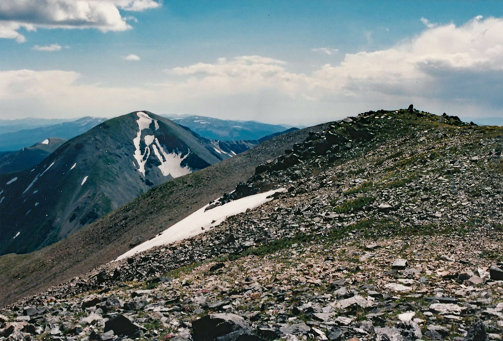
Once you've summited Alamosito, continue on south to Purgatoire. Descend to the saddle at 12,827 ft. on a little more rocky terrain with scree & some tundra. Watch for elk in the basins on either side. Then ascend the steeper north ridge of Purgatoire on mostly tundra with embedded rock and a well-worn game path all the way to the summit. The summit is large & flat with small rock and a very large rock cairn. This cairn may even be visible on Google Earth. Enjoy the panoramic view in all directions and with only a little effort, you should be able to spot some elk in the vicinity, and we're not talking about a dozen or so, but approaching the hundreds. It took us about 4 hours to reach this summit from our car park. Return as you came which will add significantly to the total elevation gain for the day. Once back at the 12,909 saddle west of Vermejo and north of Alamosito, you may want to include Vermejo for the day.
-
Vermejo Peak West Ridge Class 2 / 2.4 mi / 1,455’ One-Way
Click thumbnail to view full-size photo + caption
Open This Route in a New WindowVermejo Peak is the third in a sequence of three ranked 13ers we did in 1995 and could include a 4th. The trailhead start for this sequence is the upper parking at 11,680 ft. If parking back at the "four-point" area, add 1.2 miles one-way or 2.4 miles round-trip to our estimates. Back then, the ranch was called the "Taylor Ranch" and the ranch foreman was a man nicknamed "Stet." The sequence we describe here, we had permission to do at that time. It is not likely under the new ownership that this route could be duplicated with permission, neither do we encourage anyone to attempt to do this without permission. Just a few years back, one hiker took it upon himself to tackle some summits on the ranch without fully divulging his intentions, arrived after curfew which resulted in a S&R being launched by the ranch owners and ultimately resulted in more strict regulations being placed on the climbing community.
Vermejo Peak is part of the vast Cielo Vista Ranch which is all private property. The ranch property line extends down the west side of the central ridge of summits that stretch all the way from De Anza Peak in the north to State Line Peak in the south. You can download a Google Earth map of the property by going to this link and scrolling on the right down to the GE map link: https://www.mirrranchgroup.com/ranches/cielo-vista-ranch/. Permission must be obtained to access any of these peaks. For several decades now, the owners of this ranch property have been the only ones to allow access to these high peaks. CF&I Steel owns some of the land on the east side and has never agreed to any access and will prosecute trespassers. Policies by the ranch owners have varied in the past regarding access to which summits and routes to them. Before attempting any peaks, make sure you have a clear arrangement with the Cielo Vista Ranch owners/managers. See the "trailhead" description for more details.
When we climbed this summit in 1995, we had permission from the current ranch manager to hike to Purgatoire, Vermejo and Alamosito peaks that day, so in the hopes that future hikers may be granted the same access, we will describe in limited detail, the route we followed. Do not attempt this unless you have permission. One way mileage and elevation gain shown is for this summit by way of Purgatoire, and back over Alamosito Peak. Elevation gain/loss may vary significantly from our estimates depending on the exact route you take. Round-trip mileage and elevation gain assume completion of the sequence as described.
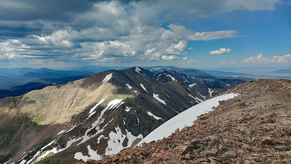
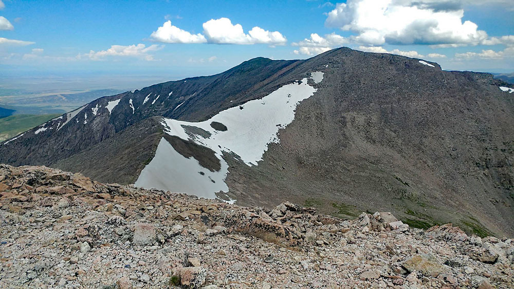
To reach Vermejo from Purgatoire Peak, walk back north on the connecting ridge to Alamosito, dropping down to the saddle at 12,827, hiking back up over Alamosito, continuing north to the saddle at 12,909, then hiking NE to the Vermejo summit. This is all Class 2 hiking on mostly tundra with some medium rubble at times. The true summit lies at the NE end of the long summit ridge. To climb Alamosito and Purgatoire first, then back over Alamosito to Vermejo took us about seven hours at an unhurried pace with breaks on each summit. If done for the day, you can descend the north ridge of Vermejo to a saddle at 12,962 ft. (Class 2) From there, you can drop back into the headwaters of North Vallejos Creek and pick up your route from the morning. It's also possible to continue north to Red Mountain and Culebra Peak following the main ridge. If doing so, expect some tundra, but as you approach Red Mtn., plenty more loose rock. (Class 2 overall)
-
Click thumbnail to view full-size photo + captionRoute Description
Year Climbed: 1995Red Mountain is the 4th in a sequence of three other ranked 13ers we did in 1995. The trailhead start for this sequence is the upper parking at 11,680 ft. If parking back at the "four-point" area, add 1.2 miles one-way or 2.4 miles round-trip to our estimates. Most climbers will have done Culebra along with Red Mountain and will not need to include Red Mountain in the Alamosito, Purgatoire, Vermejo sequence, but we are providing this information for the few that may want to do these 4 13ers plus Culebra as a long day circuit. The ability to do so will depend on the Cielo Vista Ranch policies at the time. Back when we did this, the ranch was called the "Taylor Ranch" and the ranch foreman was a man nicknamed "Stet." The sequence we describe here, we had permission to do at that time. It is not likely under the new ownership that this route could be duplicated with permission, neither do we encourage anyone to attempt to do this without permission. Just a few years back, one hiker took it upon himself to tackle some summits on the ranch without fully divulging his intentions, arrived after curfew which resulted in a S&R being launched by the ranch owners and ultimately resulted in more strict regulations being placed on the climbing community.
Red Mountain is part of the vast Cielo Vista Ranch which is all private property. The ranch property line extends down the west side of the central ridge of summits that stretch all the way from De Anza Peak in the north to State Line Peak in the south. You can download a Google Earth map of the property by going to this link and scrolling on the right down to the GE map link: https://www.mirrranchgroup.com/ranches/cielo-vista-ranch/. Permission must be obtained to access any of these peaks. For several decades now, the owners of this ranch property have been the only ones to allow access to these high peaks. CF&I Steel owns some of the land on the east side and has never agreed to any access and will prosecute trespassers. Policies by the ranch owners have varied in the past regarding access to which summits and routes to them. Before attempting any peaks, make sure you have a clear arrangement with the Cielo Vista Ranch owners/managers. See the "trailhead" description for more details.
When we climbed this summit in 1995, we had permission from the current ranch manager to hike to Purgatoire, Vermejo and Alamosito peaks that day, so in the hopes that future hikers may be granted the same access, we will describe in limited detail, the route we followed. It is likely that to be allowed to do this will cost upwards of $500 from last reports we had. Do not attempt this unless you have permission. One way mileage and elevation gain shown is for this summit by way of Vermejo. Elevation gain/loss may vary significantly from our estimates depending on the exact route you take. Round-trip mileage and elevation gain assume completion of the sequence as described.
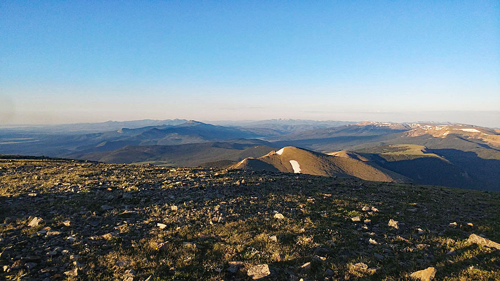
From Vermejo Peak, drop north along the ridge to a saddle at 12,962 ft. There will be one minor bump along the way to skirt or go over. If you don't want to continue to Red Mountain and Culebra, this is a good place to bale off the ridge to the west, descend back into the North Vallejos Creek and pick up your route from earlier in the day to return to the trailhead. To continue to Red Mountain, keep hiking north along the same ridge to a spot where things level out a bit just above the 13,000 ft. contour. For anyone not wanting to actually go to the Red Mountain summit, you can contour NNW on the west side of Red Mtn., gaining about 300 feet in elevation to the saddle between Red Mtn. and Pt. 13,599 on the ridge that connects Red to Culebra. This contour will be almost completely on loose rubble, but is not too difficult. Otherwise, proceed on up the ridge to the summit of Red Mountain, hiking on mostly all rubble. You've now bagged your 4th 13er for the day. Congratulations. Now to get back to the trailhead. To do so, hike the ridge toward the Culebra summit. This will entail an overall gain of 650 feet. If you've already done Culebra and have no desire to return to the summit, you could try to contour across the SW face amid more rubble and pick up the standard trail route for Culebra. For that route that includes Culebra, see our other route description for Red Mountain. Continue back to the TH and a well deserved rest with your favorite cooling beverage and dip of the feet in the nearest stream. Just be sure and exit the ranch by the required time.
Additional BETA
Links to other information, routes & trip reports for this peak that may be helpful. -