LoJ: #300 (Pre-LiDAR #295) / 13,437' T 5
Peak Summary
With 4WD access into Governor Basin, this can be quick and easy Class 2 hike to a peak with superb views, especially of the summits surrounding Yankee Boy Basin. Can be climbed from Governor Basin or the Imogene Pass Road above Telluride.
T.5 Middle Basin Access Route
-
-
Imogene Pass/Tomboy TH
The trailhead may be reached from either Telluride or Ouray. It will be a longer drive on 4WD road from Ouray. Either access requires 4WD with good clearance. The Imogene Pass road is generally far better than the Black Bear Pass road, but should not be underestimated. Local jeeping groups rate it a class 4 or 4.5 out of 5 classes. There's still plenty of rocky sections, tight curves and narrow sections with drop-offs. We would not recommend longer bed pickups or similar vehicles. We have driven this road several times in the past with a Jeep Cherokee Sport and once up from Telluride with a Toyota T-100 pickup.
From Ouray, drive south out of town on US550 to the first switchback (about .4 mile) and watch for the turnoff for the "Camp Bird Road," (Ouray County Road 361). Drive on graded dirt to the well-marked turnoff for Imogene Pass near five miles in from the highway. On the Uncompahgre NF map, the Imogene Pass road is labeled as 26B. On Trails Illustrated #141, it is listed as FR869. Proceed up the pass, stop and admire the view at the summit, then drive on down the Telluride side to the Tomboy Mine ruins. About a half mile past Tomboy is a road that angles off to the right. Park here at the coordinates provided above.
From Telluride, the turnoff for Imogene Pass is near the center of town. Drive into town on HWY145 which becomes W. Colorado Ave. Turn left onto N. Aspen St. and drive 2 blocks. Turn right on W. Galena St. and drive 1 block. Turn left onto N. Oak St. and drive one more block. The graded dirt "Tomboy" road takes off to the right. Follow this spectacular road as it rises high above Telluride, and winds through different drainages and varying forest. It will be a slow 3 - 4 miles to the coordinates provided above for the vehicle park, where a road angles off to the left. Just past the turnoff, the main Tomboy Road crosses a creek and just beyond there are the ruins of the Tomboy Mine. From the Telluride side, this road is labeled "K68." On Trails Illustrated map #141, it shows as FR869.
Camping
For this access, there are a limited number of camp spots as you drive up the first few miles of Ouray County Road 361. One spot is called "The Angel Creek Campground," followed by the "Thistledown" campground. (See links below) Be careful regarding private property. In past years, we had been able to car camp in the vicinity of where the Governor Basin road turns off from the Yankee Boy Basin road. This may no longer be allowed. Then, there's a good campsite if you're able to drive up the Governor Basin road at one of the switchbacks at about 11,360 ft. at these coordinates: N 37° 58' 37.52" W 107° 45' 42.57"
Link to Angel Creek CG http://www.fs.usda.gov/recarea/gmug/recreation/camping-cabins/recarea/?recid=32524
Link to Thistledown CG http://www.fs.usda.gov/recarea/gmug/recreation/camping-cabins/recarea/?recid=32818
From the Telluride side, there's really little good camping close by. There is a designated campground at the "Town Park" located on the east end of town, but good luck finding an open site. Your best bet may be sleeping in your vehicle near the trailhead and/or around the old townsite of Tomboy.
Click thumbnail to view full-size photo + captionRoute Description
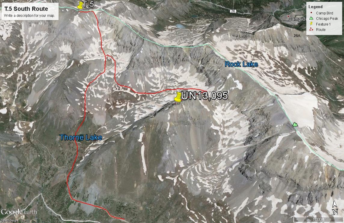
Year Climbed: 2003From the car park coordinates, walk NW along an old road that may have a locked gate and marked as Private Property. We saw no human activity beyond here, so you decide how you want to proceed. If concerned about being a violator, hike up the mountain side slope no more than about 200 feet in elevation and a game trail should appear that you may continue following NW, then north to Thorne Lake. If you stay on the road, after about 1/3rd mile, a faint trail turns off the road anyhow and leads up to Thorne Lake. Beyond the lake, continue on an old roadbed/trail into Middle basin, below the Montana Mine. From here, you could try gaining the sharp and narrow south ridge of T.5, but the appearance of numerous rocky difficulties along that ridge prompted us to try another route. So we aimed for a large couloir that drops to the Montana Mine from just east of the T.5 summit. As you head north above the mine, you'll immediately encounter some steep scrambling up a rocky slope to another bench level at just below 12,600 ft.
From this upper bench, head into the couloir. The bottom few hundred feet will be mostly medium-sized, loose rocks that are reasonably stable. The higher you ascend however, the more the rocks give way to steeper gravel and sand. Footing becomes tenuous. About 400 feet up, it becomes so steep, that to keep forward progress going, we found it useful to plunge our ice axes into the sand/gravel in order to pull ourselves up. Only the last 100 vertical feet offer any relief in steepness. Then it becomes a quick and easy stroll over small scree to the summit. The only good news regarding this route is if you descend the same way, you can scree/ski your way down quickly. If taking this route, you may want to consider dropping back down into Middle Basin and crossing east over to climb both Chicago Peak and UN13,095. be warned though, most all of that route will be on cruddy, loose rock.
Additional BETA
Links to other information, routes & trip reports for this peak that may be helpful. -