LoJ: #168 (Pre-LiDAR #163) / 13,662' Carbonate Mountain
Peak Summary
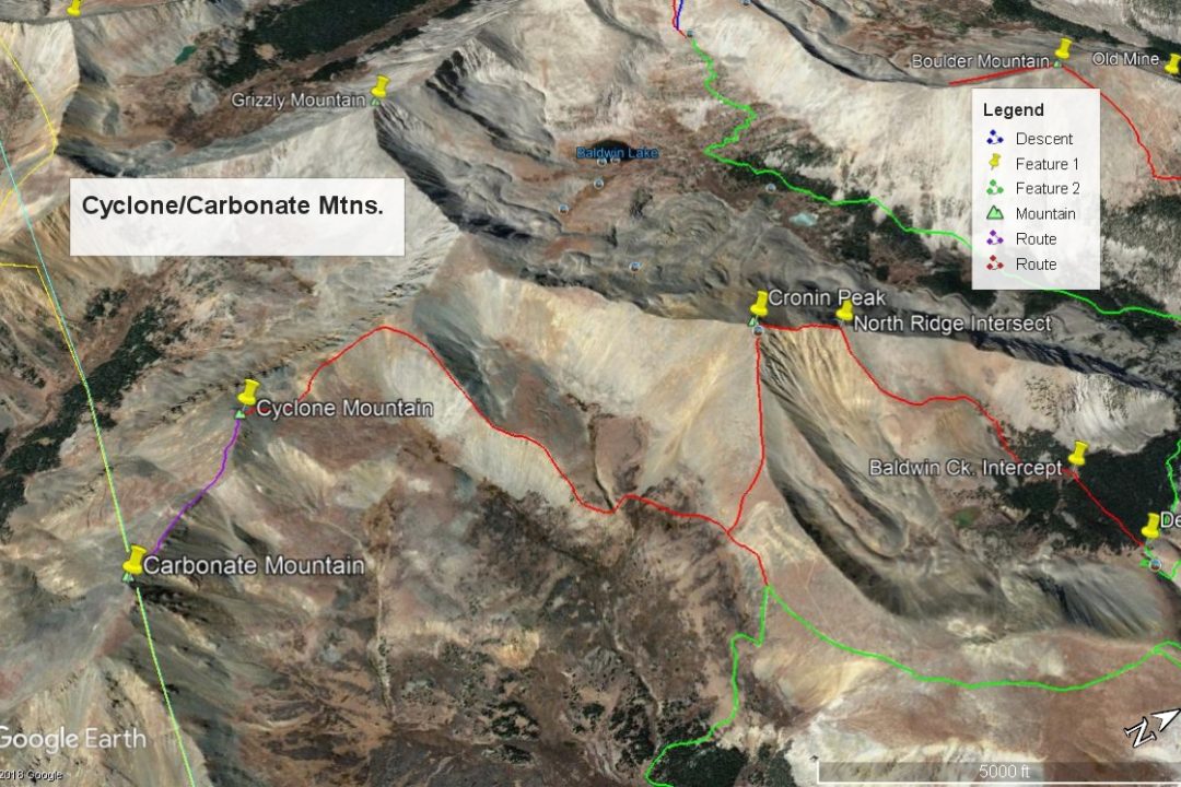
Carbonate Mountain is another Class 2 walk-up summit in the central Sawatch near St. Elmo and Mount Antero, Shavano and Tabeguache Peak. Carbonate pairs easily with another 13er, Cyclone Mtn., so we have sequenced these two together. Both may be hiked from several possible directions that include: Baldwin Gulch/Baldwin Lake & Grizzly Mountain; the North Fork Reservoir area and Cyclone Creek or the Baldwin Gulch-Mt. Antero to Browns Creek area. All of these require a 4WD vehicle with good clearance and some significant driving time. The route description we provide utilizes the Baldwin Gulch/Mt. Antero/Browns Creek access.
Carbonate Mtn NW Ridge Route
-
-
Baldwin Creek TH
From the center of town in Buena Vista at the US285 and CR306 intersection, drive south 8.1 miles south on US285 and turn right onto CR162. If coming from Johnson's Corner, drive south 5.7 miles to CR162. This is also known as "Chalk Creek Drive" and heads up towards the Mt. Princeton Hot Springs and takes you below the spectacular Mt. Princeton Chalk cliffs. Drive west on this road for 12.5 miles to the townsite of Alpine. Or measure from the end of the pavement 2.0 miles. Across from Alpine Reservoir is the turnoff for FR277 that heads up Baldwin Creek. There is very limited parking here. You may be able to find some parking around Alpine, but most everything is private property, so be careful where you park. Summer of 2019, we noticed a lot of vehicles parked along the road both before & after the trailhead.
It is possible to drive up the Baldwin Creek road if you have 4WD or 2WD with very good clearance. Every time we've been on this road (and that's quite a few), we have found it tediously rocky and slow and with more and more 4WD's, ATV's, etc., it is not likely to improve. We were last here summer of 2019 and took a quick look at the road condition. Personally - we would not advise going up this road any longer unless you have 4WD with excellent clearance. That said, we did notice signs indicating that some actual work (road repair) was going on, so perhaps there will be some improvements. This trailhead will be somewhat unique in having an "Upper Trailhead" as well. This is where FR277 and FR278 split with FR278 heading off to the left (SE) and immediately crossing Baldwin Creek. FR278 heads up onto Mt. Antero and eventually crosses over into Browns Creek. FR277 continues SW up along Baldwin Creek to a switchback where a trail to Baldwin Lake heads off. Trails Illustrated shows the road ending there now as does the Forest Service map. The coordinates for the FR277/FR278 intersection are N 38° 40' 57.11 W 106° 16' 22.56". Elevation there is 10,870 ft. The distance from the lower TH is 3.0 miles.
Camping
At-large camping opportunities along CR162 are very limited, mainly because of all the private property. There are National Forest, fee-based campgrounds along the way. They are: "Boot Leg" at 8,400ft. with 6 units & no water; Mt. Princeton at 8,000 ft. with 17 units; Chalk Lake at 8,700 ft. with 21 units and past the Baldwin Creek road and up toward St. Elmo, the Iron City CG at 9,900 ft. You can expect all of these to fill up on weekends. This road leading up to St. Elmo is a popular weekend destination for all types of recreationists.
Near the FR277/FR278 intersection, there are some limited, primitive camping opportunities. Drive just a short distance farther on FR277 toward Baldwin Lake and there is a good area with multiple campsites at the coordinates provided below. There are also some good primitive sites on FR278 just after crossing Baldwin Creek.
Campsite Locations
Baldwin Creek › N 38° 40' 50.08", W 106° 16' 29.15"Elevation 10,900 ft.Iron City › N 38° 42' 30.17", W 106° 20' 12.41"Elevation 9,900 ft. Turnoff is along the short stretch of road that leads down to St. Elmo. This campground has 15 sites, one vault toilet and an untreated water pump that we could not get to work.
-
From Cyclone Mountain
Open This Route in a New WindowThis most difficult aspect of this route description will be the drive up FR278 on the west side of Mt. Antero. From the intersection of FR277 & FR278, (Upper Baldwin Gulch TH) head SSE on 278 continuing up through forest until you reach the last trees at just above 12,000 ft. The road turns east and heads briefly up a gully before making the first of six sharp switchbacks to gain elevation on the flank of Antero. After the sixth switchback, the road heads generally south and crosses a ridge at 13,100 ft. This switchback section of the road is the roughest and most tedious part of the drive (or hike). If hiking this section, attempts to shortcut the switchbacks will lead to frustrating loose rock conditions on a very steep mountainside.
At the ridge crossing at 13,100 ft., there is a fork in the road. Going left grants access to Antero and Mount White. Stay right for Cronin and the route to Cyclone & Carbonate. The ruggedness of the road relents and cuts downhill to the SW through tundra to an intersection at 12,670 feet where you can pull off and begin a hike for Cronin, if you've managed to drive this far. Another option is to lose another 200 feet in elevation and part at a switchback at these coordinates: N 38° 39' 01.02" W 106° 16' 15.04". Elevation is 12,460 ft. This park can be used to access either Cronin or Cyclone & Carbonate.
From the vehicle park at 12,460 ft., walk west on an old roadbed that crosses a broad area of talus. Beyond the talus, leave the roadbed and head more to the SW, losing some elevation to cross one of the main forks of Browns Creek. Immediately after crossing, gain the east-west running ridge that descends from Pt. 13,591. Lower down the USGS map also marks another elevation point at 12,738 on a broader section of ridge where things level briefly. Ascending this ridge by hiking WSW is fairly easy with a mix of mostly tundra to begin with, then embedded rock and increasing rubble. Contour south as you near the summit of "Low Carb," (Pt. 13,591) if you have no desire to summit an unranked peak, then gain the south running ridge to Cyclone, dropping first to a saddle at 13,340 ft., then gaining 250 feet to the summit of Cyclone. The balance of the hike tends to be on less tundra and more gravel, scree, chiprock & rubble. There is a hikers use trail all along the ridge. It's all fairly easy hiking. In earlier season, an ice axe may prove handy while traversing the more north-facing aspects of this route. From the summit of Cyclone, continuing on to Carbonate is a quick & easy traverse.
Route Description
Year Climbed: 1989Carbonate Mountain is sequenced with Cyclone Mountain for a quick, easy pair of Top 200 summits. One-way mileage and elevation gain are measured from the summit of Cyclone Mtn. Round-trip mileage & elevation gain assume completion of the sequence as described.
From the summit of Cyclone Mountain, walks southeast along the ridge crest, first losing 335 feet of elevation, then regaining 400 feet to reach the summit of Carbonate. The terrain is largely tundra with embedded rock, rubble and chiprock. Google Earth shows a number of game trails and "use" trails near or along the ridge that make hiking easier.
Alternate route suggestions: From US 50 & Poncha Springs, drive west to Marysville and turn north onto FR240. Drive NW up this rough, rocky road toward the North Fork Reservoir. A hike up Carbonate/Cyclone can begin from two possible locations: 1. Jennings Creek where an old trail that was commonly used for Tabeguache is still usable (but the Forest Service prefers people not to use). The trailhead can be difficult to spot. See a report on Mountain Handbook. Either hike all the way up to the Tabeguache/Carbonate saddle and turn left or part way up Jennings Creek, cut left and gain the south ridge of Carbonate. 2. A half mile past the Jennings Creek TH is the Cyclone Creek TH. Proceed NW up that trail for a quarter to a third of a mile, then cut right up through open forest to gain the SSW ridge that joins the main south ridge of Carbonate. This tends to be a long talus slog with some tundra relief.
Additional BETA
Links to other information, routes & trip reports for this peak that may be helpful. -