LoJ: #73 (Pre-LiDAR #69) / 13,905' Casco Peak

Peak Summary
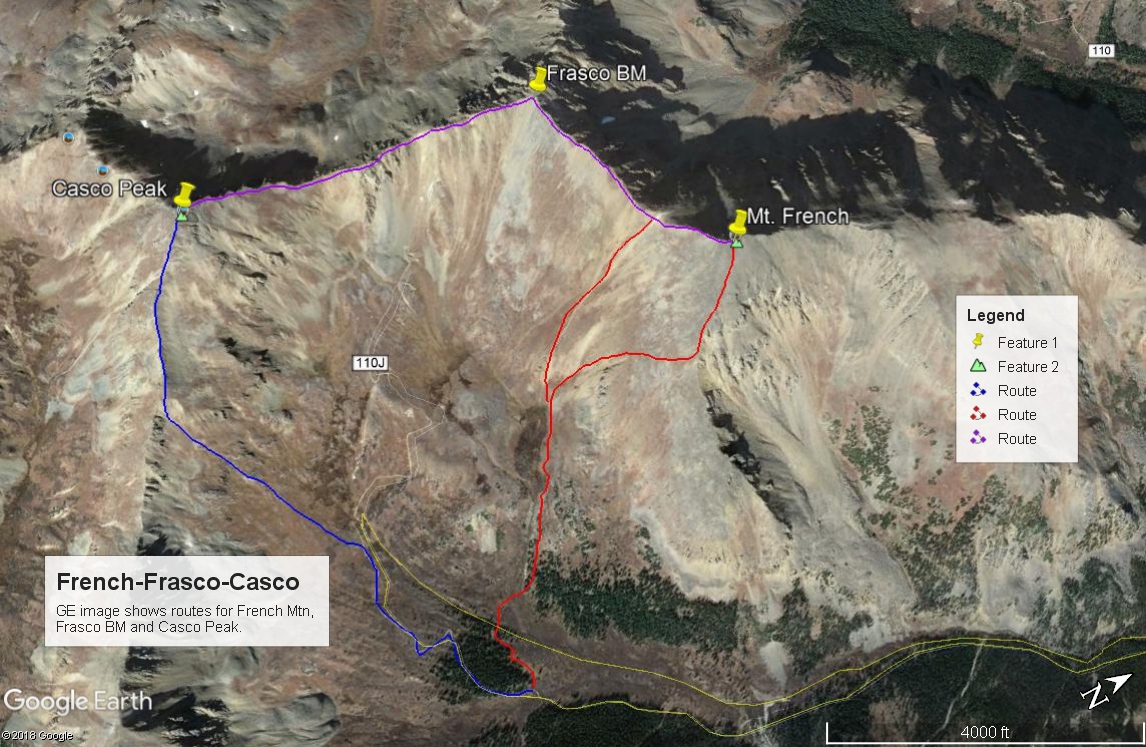
Casco Peak is a more difficult Class 2+ summit when accessed via its north ridge from Frasco BM. It ranks in the top 100 Colorado peaks. The hiking mileage without 4WD is fairly long, especially when Frasco and Casco are included in the day, which is typical for a climb of these peaks and how we have sequenced these summits. At least a stock 4WD is recommended to reach the trailhead for climbing any of these peaks. Short bed, high clearance 4WD can get you much farther up the South Halfmoon drainage and shorten the hike, but the crossing of South Halfmoon Creek has turned back many a driver.
Casco Peak North Ridge Route
-
-
South Halfmoon Creek TH
From the town of Leadville, drive about 3 miles WSW on US24 to where the highway makes a sharp tunr to the south. At the intersection here, turn west onto CO300, cross the railroad tracks and drive .8 mile west to another intersection. Turn left (south) onto CR11 and drive 1.3 miles to another intersection where you will bear right, remaining on CR11 which in time will become FR110. Continue SW on the graded, gravel road for another 5 miles eventually passing the Half Moon East and West Campground and the Elbert Creek CG. About .3 mile west of the Elbert Creek CG is the trailhead for Mt. Massive, appx. 7 miles in from US24. (N 39° 09' 05.87" W 106° 25' 09.77") The Mt. Elbert TH is located just south of the entrance for the Elbert Creek CG. (N 39° 09' 08.40" W 106° 24' 43.25") If you do not have a vehicle with better clearance, you'll need to park at the trailhead. Otherwise, FR110 continues west for another 2.1 miles to the intersection for FR110J (aka" 1103A). While this last two miles is rated 4WD, having that capability is not as important as having better clearance.
Drive south on FR110J (aka: 1103A) dropping down to Halfmoon Creek. Before crossing the creek, there's an unofficial trailhead. Our hiking route description begins from here. If you have a short wheel base, high clearance 4WD, it's possible to drive a little over a mile up FR110J to where it crosses South Halfmoon Ck. This crossing has for years stopped any number of 4WD vehicles - especially longer base ones. In 2004, our son-in-law tore the bumper off his Jeep Cherokee attempting to cross the creek here. If you have the skills and the vehicle and can get across, the remainder of the road up into the basin is not too terribly bad and you can save some significant mileage. Otherwise, you will have to park at the creek crossing and there's precious little room for doing that and it's not easy to turn around either. Best advise, park back down on either side of Halfmoon Creek and walk the road.
Camping
There are three Forest Service campgrounds along Halfmoon Creek. They are Half Moon East, Half Moon West and Elbert Creek. Information about these campgrounds can be found at this link: https://www.forestcamping.com/dow/rockymtn/sicmp.htm. These campgrounds usually max out on summer weekends. All three are listed as "first-come, first-served," so no reservations accepted. Driving west on FR110 past the Mt. Massive TH on the 4WD road will offer some additional at-large camp spots as you continue up valley. There is a sizable area for at-large camping where FR110J (1103A) turns off for South Halfmoon Creek.
Campsite Locations
Elbert Creek › N 39° 09' 09.16", W 106° 24' 48.74"10,075 ft.Half Moon West › N 39° 09' 27.30", W 106° 23' 52.32"9,950 ft.Half Moon East › N 39° 09' 32.36", W 106° 23' 48.64"9,935 ft.
-
From French Mountain Frasco Benchmark
-
French Mtn. SE Ridge & flank Class 2 / 5.0 mi / 3,650’ One-Way
Click thumbnail to view full-size photo + caption
Open This Route in a New WindowFrench Mountain is the first summit in a sequence that includes Frasco BM and Casco Peak. The trailhead begins at the crossing of Halfmoon Creek. Only short-bed, high clearance 4WD should attempt to drive up FR110J, mostly because of the crossing of South Halfmoon Creek. Some stock vehicles may make it as far as that crossing, but historically, the crossing of the creek has been very rough and has turned many a vehicle back. Unless a bridge has been rebuilt, you will also have to do a low-water crossing of Halfmoon Creek, which in runoff season can be a dangerous proposition. Use good judgement. Discretion is the better part of valor.
From the trailhead, cross Halfmoon Creek. Our last visit here in 1994, there was still one log across the creek left over from the remains of an old mining bridge. Walk south up FR110J which gains about 200 feet in elevation above Halfmoon Creek before beginning a long switchback to the west and then back SE, before heading more south again for the crossing of South Halfmoon Creek. That crossing is about 1.1 mile up from the trailhead. Find your way across the creek (wading, jumping, rock-hopping, etc) and continue up the road. On our last visit in 1994, there were still some old logs here to cross on from an old bridge. Hike a total of about 3.6 miles to an elevation of about 11,725 ft. There's a brief opening here between the trees. On the USGS map, this will be the last group of trees the road passes through in the basin. Turning off the road to the west, just after crossing one of the branches of South Halfmoon Creek, utilize the trees to avoid willows and cross the next branch of South Halfmoon Creek. The willows here are at least not the "man-eating" type. Work your way WNW about 100 feet in elevation up the hillside through willows to another group of trees. Staying on the north side of yet another stream and in the open trees will help you avoid willows. Follow along the stream to an area where things level out at about 12,300 ft. There's a large collection of willows here that can be avoided by hiking on the north side. Hike to the west end of the willows where the slope up to Frasco BM and French steepens (12,450 ft.). Here, you can make a choice.
Some will want to head directly up to the French-Frasco saddle and from there, turn right to reach the summit of French. This is a good choice but will lead to some redundant ridge walking. The slope up to the saddle is mostly low, grassy tundra. If you wish to avoid doing the ridge walk from the French-Frasco saddle twice, you can head uphill a little more to the right from the end of the willows and aim to intercept the SE ridge of French by hiking up the south flank of French. There will be some obvious rock outcrops and set of gullies to avoid, but most of this slope will also be on low, grassy tundra until you've gained the SE ridge. Once on the SE ridge, the terrain becomes more rubbly with patches of low tundra, rubble and scree before arriving at the rockier summit. All very typical Sawatch terrain. The summit of French will offer an impressive view of the Mt. Massive complex. You'll also be able to examine the connecting ridge over to Frasco, then Casco.
-
Frasco NE Ridge Class 2 / 0.6 mi / 255’ One-Way
Click thumbnail to view full-size photo + caption
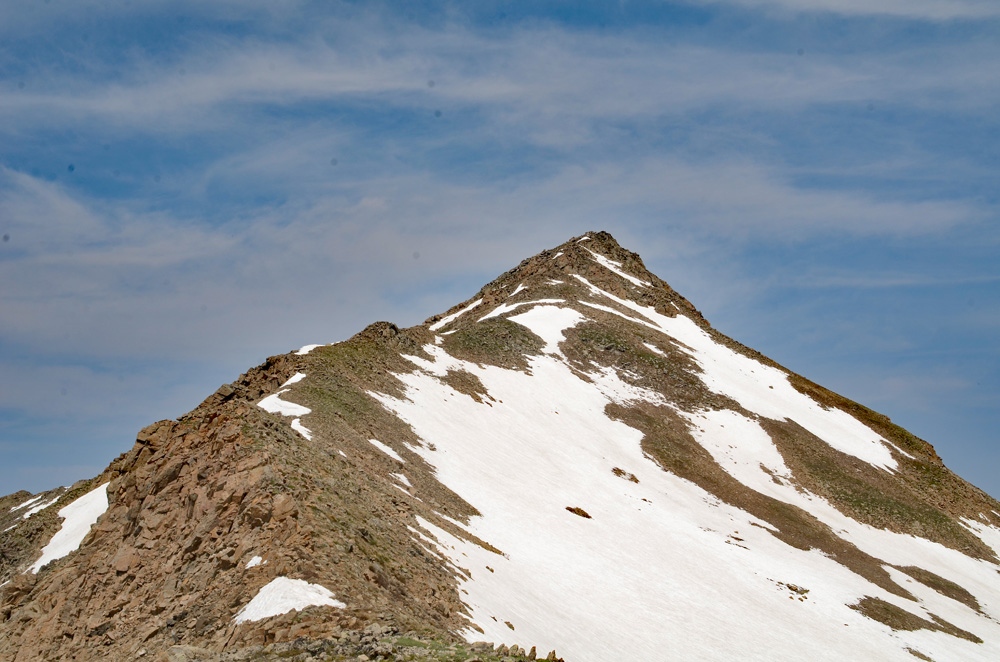
Open This Route in a New WindowFrasco Benchmark is the second summit in a three-peak sequence that begins with French Mountain. Frasco itself is unranked but most hikers will summit it on their way to Casco from French. One-way mileage and elevation gain are measured from the summit of French Mtn. Round-trip mileage and elevation gain assume completion of the sequence.
From the summit of French Mtn., walk WSW along the ridge crest to the French-Frasco saddle, losing about 300 feet in elevation. After the saddle, regain 255 feet in elevation to the Frasco summit. From the saddle to the Frasco summit, the terrain becomes a little more difficult with more rocks and rock outcrops to navigate. Nothing however exceeds Class 2 walking. There will still be embedded rocks with low tundra in places. Once you arrive at the Frasco summit, survey the ridge over to Casco. It appears to be more daunting but never exceeds Class 2+ unless you're looking to add to the challenge.
-
Click thumbnail to view full-size photo + captionRoute Description
Year Climbed: 1994Casco peak is sequenced with French Mtn. and Frasco BM. One-way mileage and elevation gain are measured from the summit of Frasco BM. Round-trip mileage and elevation gain assume completion of the full sequence.
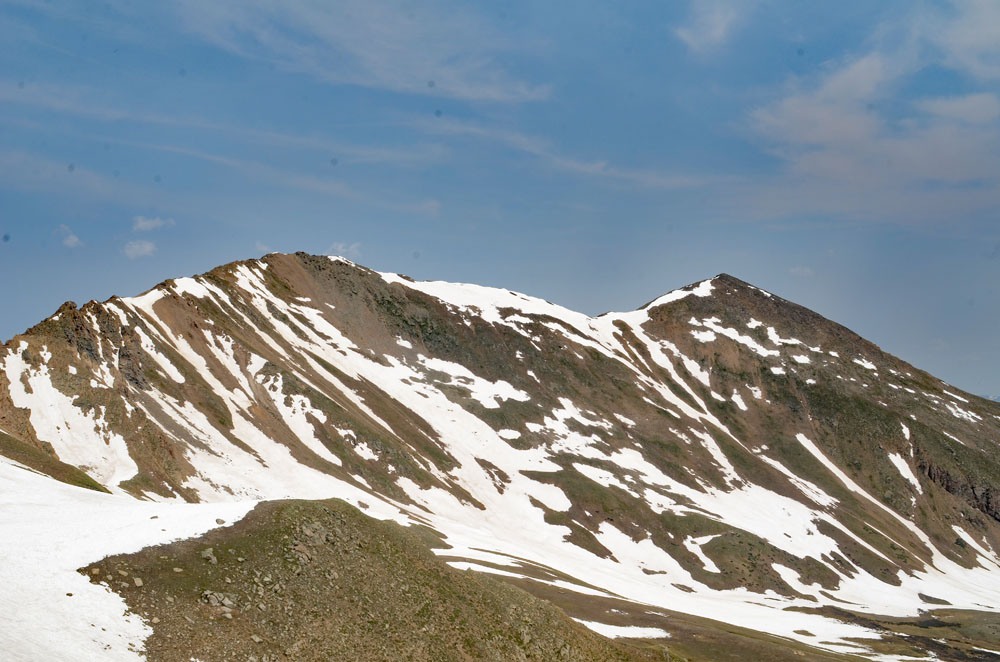
From the summit of Frasco BM, keep walking south, heading down the ridge that connects to Casco. You will lose 615 feet in elevation on your way to the Frasco-Casco saddle. The descent starts out on small rubble & scree, then transitions to low tundra and embedded rocks. At 13,540 ft., you will come to an area of dirt/scree. This is just prior to the PT. 13,470 indicated on the USGS map. To continue to the Frasco-Casco saddle, you will need to stay primarily on the ridge crest and cross over four rock ribs that intercept the ridge. The ridge becomes rockier with large blocks and boulders to cross. You may as well go directly over Pt. 13,470. Getting through here can be kept at a Class 2+ level, but you can also find some brief 3rd class scrambling for fun. One last rocky section will get you to the saddle. From there head up to the summit of Casco on mostly low tundra with embedded rocks until you come to the final summit section. Things turn rockier again with some slabs, ledges and large boulder blocks to finish on but low tundra makes it all fairly easy. All in all, this is a fun ridge hike unless you're dodging lightening bolts or fighting fierce winds. The summit is comprised of a large rock outcrop with no comfortable place for a group to sit or rest.
The summit offers a nice view looking down into the South Halfmoon Creek Basin below and an impressive view of La Plata to the south. There is also a long two mile ridge that runs SE over to Bull Hill for the more ambitious hiker to contemplate. Otherwise, to descend, continue down the Se ridge of Casco on easier terrain - mostly low tundra with embedded rocks, and descend all the way to about 13,200 feet. Leave the ridge and descend ENE back into the South Halfmoon basin. In early season, you may find a nice glissade here so bring an ice axe if that's a possibility. In 1987 we climbed these peaks with our friend Bob Alden. On the way down this ridge, he wanted to get in a glissade so he headed down a little earlier than we thought safe and began to glissade down a chute. The snow he was on was in that late spring, slush stage and it began to avalanche rather slowly, but with enough force to propel him down the mountainside uncontrolled and depositing him onto some rocks. The result was a somewhat shredded hip and upper thigh, but he was still able to hike on out the multiple miles back to his vehicle. Just a small lesson to learn. The old road will be easy to spot. Choose a spot to join it and begin the long hike back to your waiting vehicle.
Additional BETA
Links to other information, routes & trip reports for this peak that may be helpful. -