LoJ: #87 (Pre-LiDAR #91) / 13,850' Holy Cross Ridge
Peak Summary
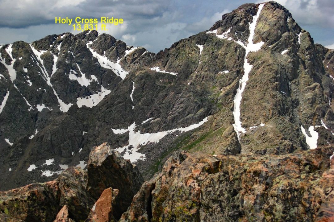
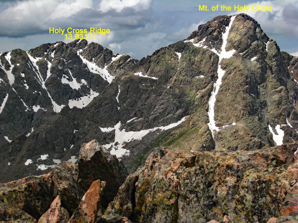
UN 13,831/Holy Cross Ridge is a stiff Class 2 ascent that can be combined with a climb of Mt. of the Holy Cross if desired. The trailhead is the Half Moon TH at the end of the Tigwon Hut road out of Minturn. The road is typically passable for most cross-over type vehicles. One-day, round-trip mileage is excessive. The traverse from Mt. of the Holy Cross to Holy Cross Ridge involves some major boulder-hopping work. It is also possible to reach Holy Cross Ridge by hiking from the southern end of the long ridge to the 13,831 summit. This more than 2 mile long ridge hike is one of the most tedious we have ever attempted being nothing but a boulder fest for almost the entire distance. While this southern route remains a Class 2+, we do not recommend it.
Holy Cross Ridge - North section Route
-
-
Half Moon - Fall Creek TH
Whether coming from the east or west on I-70, take the Minturn exit # 171 and head south on US24 to the town of Minturn. When the highway comes into town at the north end and makes a fairly sharp right turn, it's about 3.5 more miles south to the turnoff on the right for the Tigiwon Road (FR707). The turnoff is just before the highway crosses Eagle Creek. If coming on US24 from Leadville, the turnoff is after the last switchback as you descend from Battle Mountain. After that switchback, the highway crosses the Eagle River and the turnoff will be almost immediately after that crossing on the left.
Once on the Tigiwon (on some maps labelled Tigwon) it's a long drive on a graded, gravel road that meanders through countless turns and switchbacks to the trailhead. There are beautiful stands of aspen and open meadows. Total distance is about 8.5 miles. About 6 miles in, there's a small campground that is not listed on the White River NF website, just beyond the Tigiwon Community Hut. Overall, the road can be somewhat rough, but most passenger vehicles should be able to make it to the TH. Cross-overs & standard SUV's would be a safer bet. This road may not be open until mid-June some time. Check the White River National Forest website for more info. Both the Half Moon trail and the Fall Creek trail take out from here. Be careful to correctly identify the trail you desire. There is a small, national forest campground on a spur road from the trailhead. This will almost always be filled on summer weekends. There's only 7 sites. Primitive campsites along the Tigiwon Road are limited. Parking can also be a hassle on weekends with so many climbers coming to do Mount of the Holy Cross, you may end up parking along the side of the road as much as a quarter mile back from the trailhead, even on a Friday evening.
Camping
There is a very small campground (Half Moon) at the trailhead area which was re-worked several years ago. There are only seven sites and a fee is charged. The campground is first-come, first-served. Some sources indicate a campground near the Tigiwon Community Hut. The White River NF makes no mention of it. Camping at the Tigiwon Hut is prohibited, but on Google Earth, you can see some primitive sites just up the road from there. Attempt to camp at your own risk. The Half Moon CG can be expected to be fully occupied on any summer weekend. Also, because the Half Moon Pass trail is the access to Mt. of the Holy Cross, and that summit is one of the more popular 14er destinations for Front Range peakbaggers, the limited trailhead parking fills immediately on weekends and later arrivals will find themselves having to park a substantial distance back down the road.
Campsite Locations
Half Moon › N 39° 30' 04.16", W 106° 25' 54.90"10,315 ft. elevation
Route Description
Year Climbed: 1994The route for UN 13,831, aka: Holy Cross Ridge, utilizes the main North Ridge Route for Mount of the Holy Cross. In fact, it's just as easy to take the trail all the way to the summit of Mt. of the Holy Cross, then descend to make the traverse to HC Ridge, rather than attempting to contour below the summit of Mt. of the Holy Cross on the west flank over to the connecting saddle for HC Ridge. Because of abundant sources for Mt. of the Holy Cross, we will not go int great detail about trail to that summit. We have also sequenced HC Ridge with UN 13,768 so if adding both to your day, the overall mileage and time required will increase significantly.
From the trailhead, be sure and take the trail for Mt. of the Holy Cross which will cross over Half Moon Pass. Do not take the Fall Creek trail. 1.7 miles of hiking a fairly gentle gradient will bring you to the pass, starting out in forest and moving into more open meadows with abundant wildflowers. From the pass, continue generally west on the trail 1.4 miles dropping down to East Cross Creek. After crossing the creek, the trail continues west for a short while, then turns south to begin gaining the Holy Cross north ridge. The trail eventually leaves the trees and for the remainder of the hike, passes through mostly talus and boulder-sized talus to reach the summit. It's another 2.6 miles to the summit of Mt. of the Holy Cross. You could perhaps, skip the summit and try to contour about 300 feet below to the south, over to the saddle at 13,500 feet, but navigating your way across the mighty boulders with no trail becomes a tiresome task. Save your energy for more important things.
From the summit of Mt. of the Holy Cross, walk SW down the ridge. Things become a little more gentle at 13,680 ft. The rock is not so bad and you feel like you can make better progress. It stays fairly reasonable down to the saddle. As you ascend from the saddle to HC Ridge (13,831), the terrain reverts back to more of what there is while approaching the summit of Holy Cross. It's just another tedious scramble of large boulders, etc. Total time for the traverse for us was 45 minutes. The summit is small and rocky. From the summit, make a decision as to how much more abuse you want to put up with. Continuing on to UN 13,768 will be similar conditions.
Additional BETA
Links to other information, routes & trip reports for this peak that may be helpful. -