LoJ: #60 (Pre-LiDAR #59) / 13,960' Ice Mountain

Peak Summary
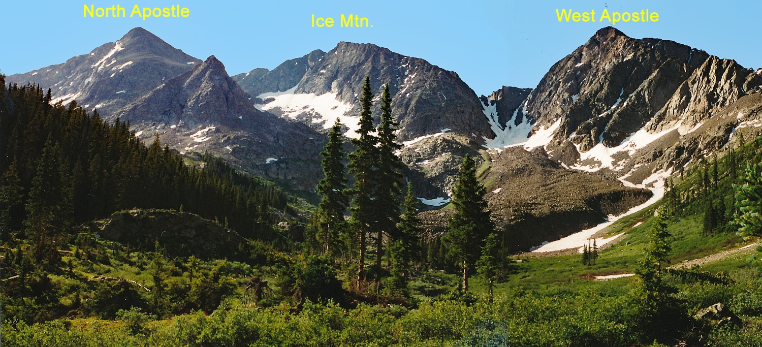
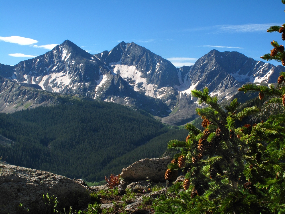
Ice Mountain is a Top 100 summit with a nice Class 3 scramble. A vehicle with good ground clearance is best for reaching the trailhead, but this summit can be completed in a single day with a start from Winfield - which is a point most passenger type vehicles should be able to make. Ice Mountain is often climbed together with North Apostle and sometimes West Apostle. We have sequenced it with North Apostle only. It is the middle summit of the "Three Apostles." The overall route is now well-defined.
Ice Mountain NE Ridge Route
-
-
Clear Creek/Winfield/Apostles TH
From Leadville, drive south a little over 19 miles on HWY 24 to the turnoff for Clear Creek Reservoir (CR390) and head west. The turn is less than 2 miles south of "Granite." From Buena Vista, drive north just under 15 miles to the same turnoff. Drive west on graded dirt road 11.7 miles to Winfield. As the road approaches Winfield, it will become a little more narrow and likely to have some potholes. Because of heavy use, this road is often washboarded badly. At Winfield, turn south and cross the creek and continue south, then SW on CR390.2B. About 100 yards after crossing the creek, passenger cars may want to park because the road greatly deteriorates beyond there. Higher clearance vehicles may continue. 4WD is not really required for the remainder of the drive to the end of the road. At a little over .7 mile after crossing Clear Creek, just south of Winfield is the turnoff for the blocked road to Lulu Gulch, UN 13,462 A and Browns Peak. From Winfield it's about 2.25 miles to the end of the road and some limited parking. This trailhead is used for both Huron Peak and routes to the Apostles.
If using this general trailhead description for access to peaks up the Lake Fork of Clear Creek (Clohesy Lake), then do not drive all the way to Winfield. Instead, you'll need to turn left at 9.8 miles in from US24 and drive down through the few cabins that comprise "Rockdale," ford Clear Creek and drive to the Clohesy Lake trailhead with a starting elevation of 10,900 ft. 4WD required for this access, otherwise, walk it and enjoy the frigid and sometimes dangerous crossing of Clear Creek.
Camping
For the access to Huron and the Apostles, best camping opportunities are along the final two miles to the trailhead from Winfield. There are several at-large spots available. Camping before Winfield can be difficult because of private property and the large number of people coming to climb Belford, Oxford and Missouri.
There are good campsites for backpackers in the vicinity of "Hamilton" along the Huron Route and the trail up toward the Apostles. There are also good campsites in the meadow just north of the rock glacier at about 11,400 feet or a little lower.
If heading up the Lake Fork toward Clohesy Lake, there is at-large camping at the trailhead which is at a large, open meadow area that's relatively flat. Coordinates are: N 38° 57' 15.48" W 106° 24' 32.64"
Click thumbnail to view full-size photo + captionRoute Description
Year Climbed: 1994We have sequenced Ice Mountain with North Apostle. One way mileage and elevation gain is measured from the summit of North Apostle. Round-trip mileage and elevation gain assume completion of the sequence.
This route description begins from the summit of North Apostle and follows the ridge that connects N. Apostle with Ice Mountain. If climbing Ice Mountain alone, follow the directions for N. Apostle to the saddle on the connecting ridge.
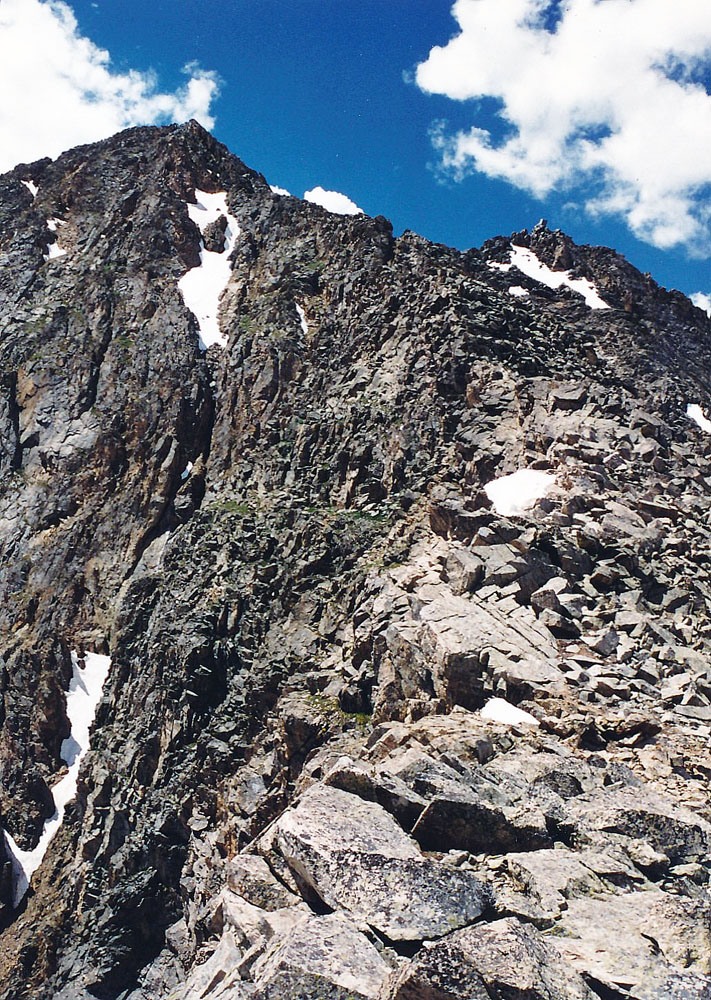
From N. Apostle, the view of the lower half of the ascent ridge to Ice Mtn. does not appear too bad. The real challenge comes on the upper half. The ridge can be followed for the most part on its crest until reaching the 13,800 foot level, at which point, the ridge becomes very narrow, precipitous and dangerous. The standard approach here has been to drop into a steep couloir to the right, ascend it back to a point on the ridge crest and then follow the remaining ridge to the summit. This couloir section is where the 3rd class work comes in. Roach has you abandon the ridge earlier at 13,620 ft. but the real crux is still the cliff on the ridge at 13,800 ft. Roach's book still advises utilizing the couloir on the west side of the ridge to avoid cliff. We all agree that this section at 13,800 ft. is the crux. Navigating the couloir when there is snow in it may require ice axe and crampons or at least micro spikes. When there is no snow, the couloir is so steep that more timid or less experienced climbers may be quite intimidated. The climbing is not that difficult but the exposure and insecure rock makes this section dangerous.
Here's what we did: From the saddle, we ascended on the ridge crest for the most part for a while and if we got off the crest, it was always on the right (west) side. There is now likely a path through this section with cairns marking the way as we found. We continued to ascend on generally good footing without difficulty, always near the ridge, but never quite on it. The path we followed, which was marked by cairns, clearly led us into a couloir. Once in it, we could not tell if we should climb out of it on the other side or climb to the head. We ended up ascending the couloir which became steepest as we approached the head. It was here that we were using hand-over-hand climbing and the steepness and exposure was intimidating. However, we never did rope up. Just when you might be inclined to turn back, we made a little push and came out of the couloir and back onto the ridge. The remainder of the ascent to the summit is Class 2 walking.
The summit of Ice Mountain affords a beautiful view. Below to the south is the less visited Texas Creek area and Waterloo Gulch on the east side of the summit. In the distance is the area around Tincup. Enjoy the stupendous view of this section of the Sawatch Range.
For the descent, we made an adjustment that seemed to work well, so keep this in mind for the ascent. From the summit, we descended the NE ridge on rock & ledges, avoiding re-entering the couloir we had gone up earlier. Instead, we followed a rib that paralleled the couloir until we could drop into it at a point close to where we first entered it on the way up. This led us back over to the more visible path on the lower ridge section. We found this descent marked with cairns in 1994. It may be tempting to depart the ridge lower down and short cut into the basin below using a steep couloir. Parties may find it to be a struggle to do so on all the loose rock and not put rocks down on each other. There re some scree sections however, that can expedite descent. The safer descent is to return all the way to the saddle and then head back down into the basin below Ice Mtn. and N. Apostle. For the remainder of the trip, return as you came.
Additional BETA
Links to other information, routes & trip reports for this peak that may be helpful. -