LoJ: #288 (Pre-LiDAR #289) / 13,455' Kendall Peak
Peak Summary
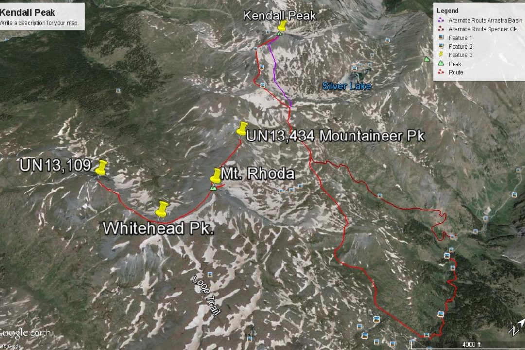
There's almost always more than one way to climb a peak. With 4WD, Kendall Peak and Kendall Mtn., can be easily and quickly climbed from Kendall Gulch, by driving south, then east out of Silverton. Our route to Kendall Peak is from the Highland Mary Lakes trail. We climbed Kendall Peak as part of a weekend trip to this area. This Class 2 route is much longer on mileage, but offers a chance to see some otherwise seldom-visited areas. Pre-Lidar elevation was 13,451.
Kendall Pk. from Spencer Basin Route
-
-
Cunningham Creek - Silverton TH
From the Town of Silverton, drive to the east end of town where the paved road splits one block past the courthouse. Set your odometer and veer right onto blue-signed County Road 2. (On Trails Illustrated map #141 this is road #110 aka: BLM 4500.) After 2 miles, the pavement ends and the road becomes well-maintained, graded dirt. At 4.2 miles, you'll come to an intersection and the old townsite of Howardsville. Turn right onto BLM 4513 or FS589. A sign here indicates Cunningham Gulch and Stony Pass. At 4.4 miles from town, stay right. At 5.9 miles, stay right again. Do not drive up the Stony Pass Road. Continue driving south along Cunningham Creek. At about 7.1 miles is the place to park to access Little Giant Peak. At 7.6 miles is an old toilet on the east side of the road and a camp area on the west. At 7.8 miles, the good road ends, but passenger cars with moderate clearance can still make it to the trailhead. Take the right fork, drop down and cross the creek, then begin climbing on a single switchback to the trailhead. At 8.6 miles, turn left and descend sharply to cross Cunningham Creek again, (This is a low-water crossing which can be difficult in runoff season,) then drive another .2 to the limited trailhead parking area. If there's no room to park here, you can park before crossing the creek on a flat area just beyond the intersection atop some old mine tailings. Trailhead coordinates provided above are for parking at the first crossing of Cunningham Creek. The coordinates for the actual trailhead are: N 37° 46' 51.43" W 107° 34' 47.30".
Camping
At either of the two trailheads, you could park and vehicle camp overnight. On the drive up Cunningham Creek, once you pass the turnoff for Stony Pass, you can find a few other pullout type spots for an overnighter. Be careful about private property issues though. Back along CO110, there are a number of at-large, primitive sites, usually occupied by RV's and the likes. The nearest National Forest campgrounds will be either up South Mineral Creek or Little Molas Lake.
If you desire to spend more than a day in the area of the Highland Mary Lakes, then there is a short little backpack you can do to a good camp location that's only about 1.5 miles in from the passenger car trailhead or about 1mile from the 4WD trailhead. It's located in the last trees north of the lakes just above 11,670 ft., on a sloping ridge between the two main forks of the creek. There's room for several tents and a good water supply. This is where the trail to the lakes takes a decided turn to the west to follow a secondary drainage. Coordinates are approximately: N 37° 46' 10.4" W 107° 34' 34.8".
Route Description
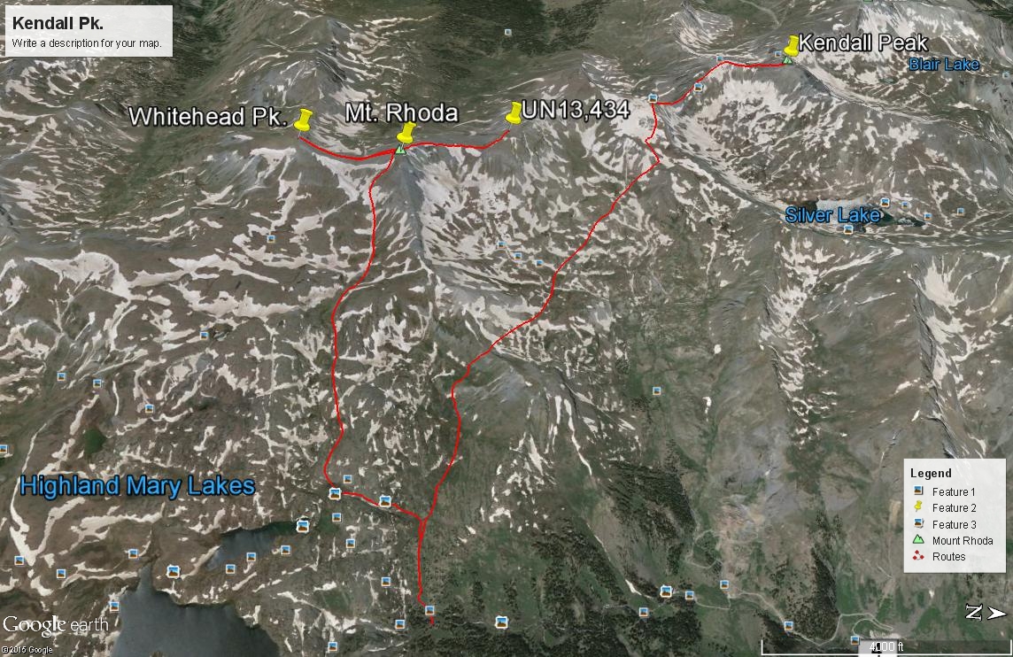
Year Climbed: 1997From the passenger car park at 10,460 ft., hike on up the road (or drive if you have 4WD) to the upper trailhead parking at 10,800 ft. Follow the trail toward Highland Mary Lakes. The trail will take a decided turn west a little below 11,600 ft., crossing the creek and will again turn abruptly south above 11,800 ft., to follow the west for of Cunningham Creek to one of the first lakes. At this last turn to the south, leave the trail and hike west up the tundra & grass drainage toward a saddle SW of "Sugarloaf." Cross the saddle on tundra and talus, then drop down into Spencer basin losing perhaps 300 feet in elevation. Cross the mostly tundra/grass basin (when we did this hike, it was almost all snow here - so tundra & grass is an assumption) heading towards a saddle east of Pt.13,409. A grass-covered slope grants access to an upper bench at 12,900 ft.
You can make a choice here. 1. Drop down into Arrastra Basin, losing perhaps 300 feet to where the steeper terrain mitigates some below the 13,409 - Kendall ridge. Then gain that ridge at the first saddle south of Kendall Peak, just above the Titusville Mine ruins. Expect plenty of rock below the ridge and regaining the ridge. If you're here early season, you may get lucky and find most of this covered in snow making traverse very easy. Ice axe will be useful. 2. Hike to the summit of Pt.13,409, then follow the connecting ridge NW and N over to Kendall Peak. The initial descent off Pt.13,409 will be rocky and difficult. The remainder of the ridge will be easy enough on a mix of tundra and typical San Juan scree and rubble. Or - "Furthermore" on LoJ reports finding a trail from the saddle at 12,900 feet that contours below 13,409 on its north side and leads back over to the low point saddle between Kendall and Pt.13,409, avoiding the rubbly mess. In his photos, the trail would apparently cut through a lot of scree and talus.
From the summit of Kendall Peak, you may want to contemplate crossing on over to the west and tagging the official high point of Kendall Mountain which is Pt. 13,338. It's about .8 mile away. We chose to not follow the ridge on over that day because of time constraints and because of a difficult looking notch just west of the Kendall Peak summit that appeared to offer a 3rd class scrambling problem. On LoJ, "Futhermore" reports an attempt to negotiate that notch unsuccessfully and has a photo of it. If you don't continue on over to Kendall Mtn, then return as you came. Returning through Arrastra Basin may be a more attractive option with an opportunity to view wildflowers, etc.
Alternate route: If driving or walking up from the passenger car park at 10,460 ft., just before the road crosses back over to the east side of Cunningham Creek, there's a mining road that heads off to the right and switchbacks up the mountainside to a mining claim at 11,300 ft. Beyond the mine, the road deteriorates to more of a trail that climbs all the way into the upper bowl of Spencer Basin, close to Mountaineer Creek. From there, you could follow the route description above. This approach could save over a couple of miles and some elevation over our suggested route, however, there may be a private property issue with this approach. Use at your own risk. National Forest maps show private holdings in this area.
-