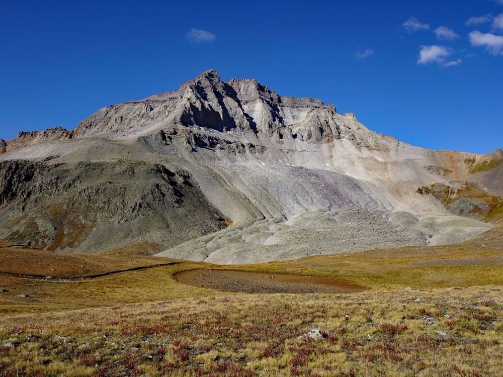
LoJ: #193 (Pre-LiDAR #197) / 13,592' Mount Emma

Peak Summary
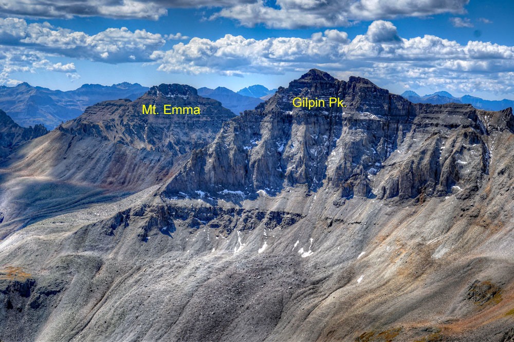
Mt. Emma is classified as a Class 3 scramble from the Yankee Boy Basin area. Passenger vehicles can make it as far as the lower section of the basin. Stock 4WD can easily make it to the solar vault toilet above 11,300 ft. and reduce the overall mileage. Mt. Emma is frequently combined with Gilpin Peak. The two summits offer highly impressive and scenic views of this spectacular alpine basin. Pre-Lidar elevation was 13,581.
Mt. Emma NE Ridge Route
-
-
Yankee Boy Basin - Mt. Sneffles Trailhead
Road up Yankee Boy has recently been improved as of 2018. The shelf sections are now smooth & graded. There should be no issues for passenger vehicles to continue up to the start of the 4x4 section at the Governor Basin road turnoff (just past the Atlas Mill) other than the washboarded switchbacks and unrelenting steepness.
To access this trailhead, head south out of Ouray on Highway 550 up Red Mountain Pass for 0.4 miles. At the first switchback, take a right onto Ouray County Road 361 (aka 'Camp Bird Road")—a graded dirt road. Immediately after this turn, the road branches with the right fork taking off toward Box Canyon Falls. Take the left fork, (just continue straight ahead actually) which will lead you on a bridge over the creek before beginning the relentless climb up into Yankee Boy Basin. Continue past the turnoffs for Camp Bird Mine & Imogene Pass and across the famous, spectacular shelf section of the Yankee Boy Basin Road (CR 26). Keep going until the road branches to Governor Basin around mile 7.75. Passenger cars shouldn't have any issues making it to this point (usually).
NOTE: The best parking may be just before the Governor Basin Road turnoff back near the Atlas Mill.
If you're driving a 4x4 vehicle, continue right farther up the Yankee Boy Basin Road for approximately another 0.9 miles to a large pullout with a solar vault toilet at around 11,380'. The 4x4 road up to the bathroom is in great condition as of 2018 as well—no obstacles of any real significance. A little clearance and low gears are helpful, but there should be no difficult maneuvers up to the trailhead that a stock 4x4 can't handle. Even some crossover vehicles should be able to make it if driven carefully.
Camping
The only camping allowed in Yankee Boy basin is now restricted to Thistledown and Angel Creek Campgrounds. As of June 2018 the Angel Creek Campground was temporarily closed "due to hazard trees." At Thistledown, there is an overflow area on the north side of the road just past the main campground thta has three or four other sites which are "walk-in" sites.
About 100 yards past the solar vault toilet, a road turns off to the left that drops down a little, crosses a larger puddle and then swings up into an area of trees. There are about five primitive campsites in among these trees. IN 2018, we observed on two separate weekends, various groups openly camping here with tents & RV's. We are not sure if using these spots is truly permissible or not. One Forest Service ranger told us that camping on FS land is not permissible anywhere in the basin, however, she also pointed out that there are all kinds of old claims in this area that are not considered FS land and that some of these areas could be used for camping. That may be the case with the spot described here, however if not on FS land, then you are on a private holding of some kind. On another trip, our son saw several people up at the various turnouts on the 4x4 section camping in their vehicles, but no tents. When he returned to the car after his climb, there was a woman associated with a Yankee Boy Basin conservation group who was checking the area round the restroom and also the trail and level area above it for signs of camping usage. She was photographing and documenting everything. Camp at your own risk on this one!
Campsite Locations
Thistledown › N 37° 59' 37.84", W 107° 42' 01.64"8,760 ft. elevation
-
From Gilpin Peak
Click thumbnail to view full-size photo + caption
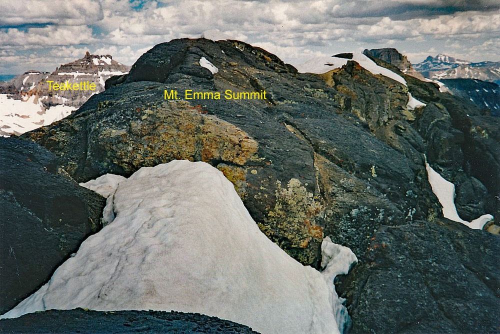
Open This Route in a New WindowGilpin Peak is sequenced with Mount Emma. Gilpin is the first summit in the sequence. Previous elevation for Gilpin prior to Lidar was 13,694.
From the suggested parking at the vault toilet at 11,300 feet located in upper Yankee Boy Basin, continue walking up the road that accesses the Mt. Sneffels trail. Follow the road to the first switchback at 11,800 ft. Depart the road and follow a trail that leads to a small lake/pond that sits at the foot of a huge rock glacier that descends off the north face of Gilpin. Continue on trail that skirts the north end of the rock glacier. At the first switchback past the end of the glacier. Depart the trail and begin contouring and gaining some elevation as you head SW, staying on as much tundra as you can. Identify the ridge that connects Gilpin over to Sneffels, which will be on your right. At some point, you'll need to make a choice: either gain that ridge with the intent of following it all the way up to the Gilpin north ridge or, head up and into a very prominent couloir that's just left of the same ridge. We did this climb in the summer of 1995 which had been preceded by a very snowy winter. Even though it was late July, the couloir was still filled with snow. If you find it in that condition, you will likely want ice axe and even crampons, which we had. The couloir was topped by a near vertical cornice that we had to work around. If there is no snow in the couloir, the hike up will be on very steep and the couloir is filled with loose talus/rubble making footing very difficult. If you aim for the ridge, rocky outcrops higher up may force some over into the same couloir.
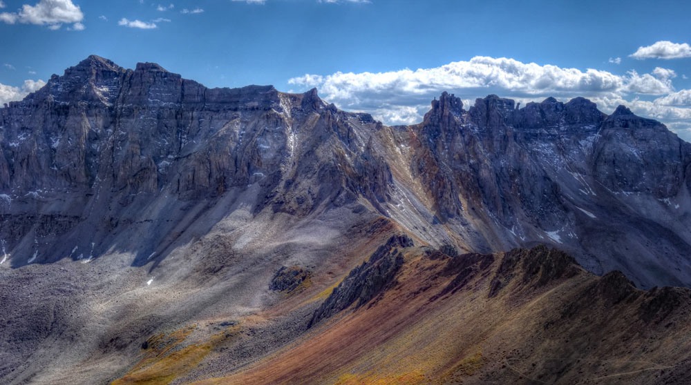
Once you reach the head of the couloir and Gilpin's north ridge, it's a fairly simple walk to the summit on broken rock typical of this area. The notch in this north ridge that can be seen from below turns out to offer no problem. From this lofty summit, enjoy the highly impressive view of the peaks surrounding Yankee Boy Basin. Mt. Sneffels across the way will seemingly dwarf Gilpin and you'll be able to see much of the standard route up it. If doing Gilpin alone, descend as you came. If wanting to continue to Mt. Emma, see that description. While older sources seemed to discourage a traverse to Emma on the connecting ridge, more recent report seem to indicate this can be done at about a 3rd class level.
Click thumbnail to view full-size photo + captionRoute Description
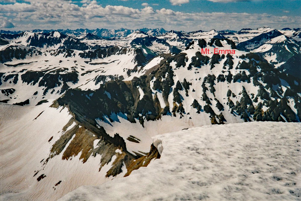
Year Climbed: 1995Mt. Emma is connected by a long ridge to Gilpin Peak and we have sequenced this summit with Gilpin, however, we did not use the connecting ridge. One way mileage and elevation gain are measured from the summit of Gilpin. Round-trip mileage and elevation gain assume completion of the sequence.
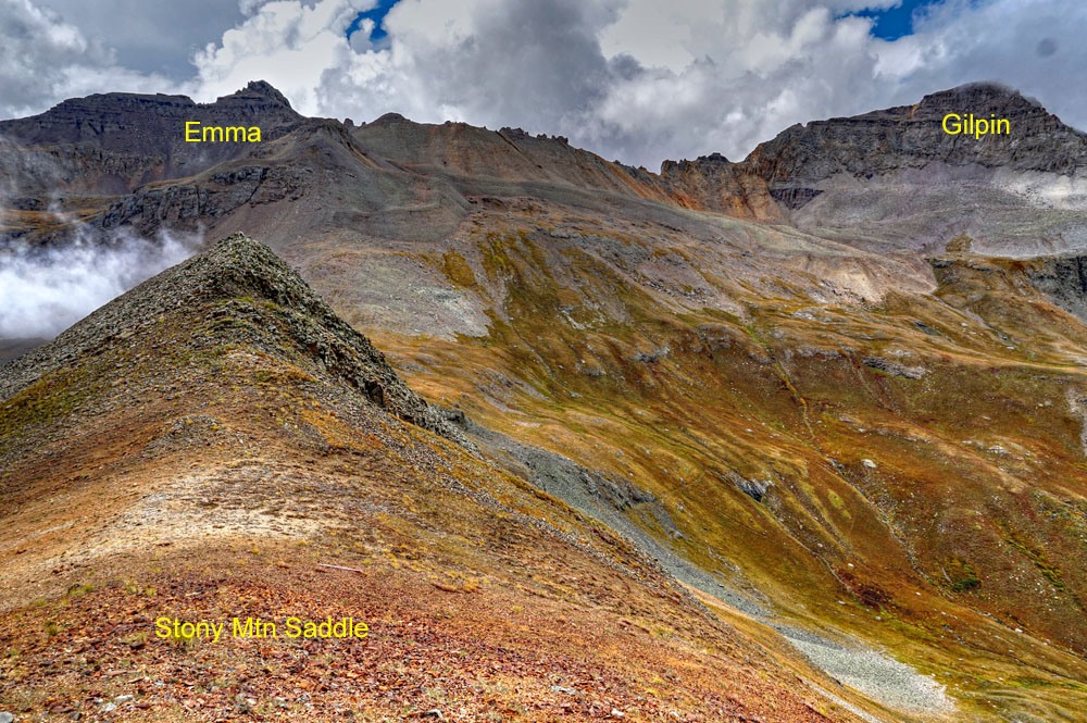
Our proposed route to Mt. Emma retraces the ascent route on Gilpin back down the couloir and descending to about the 12,600 foot level. At that point, begin contouring SE on a rocky, boulder-talus bench and cross the rugged east ridge that extends off Gilpin. Continue the contour southward into a basin that's largely below the Gilpin-Emma saddle, crossing the bottom of another large rock glacier that descends from near the saddle. After crossing the rock glacier, head towards Pt. 13,027 that's on the ridge that connects Stony Mtn., to Emma. There will be much more pleasant and manageable terrain compared to the contour under Gilpin. At this point, we should admit here that when we did this contour that avoids Gilpins south ridge, it was later July 1995 and much of Yankee Boy Basin was still covered in snow, thus the long contour was on snow and not talus making progress much more rapid and easy.
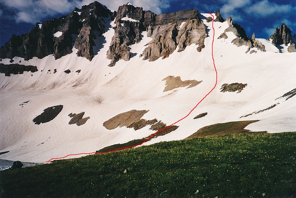
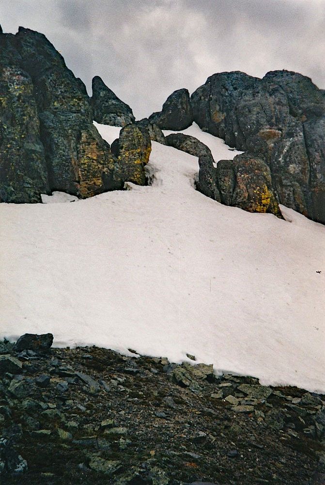
Gain the secondary ridge that extends from Pt. 13,027 to the Mt. Emma NE ridge. Either follow the secondary ridge to the main Gilpin-Emma ridge or contour SW below that main ridge for a while before coming to a couloir that will lead up to the Mt. Emma NE ridge. Once on Emma's NE ridge, head SW for the summit block. Any obstacles can be easily avoided by working off the ridge a little on either side. At the main summit block, most choose to contour out onto the Emma north face, just below the summit blocks and cliffs. If doing so, there will be three main couloirs that you can ascend up to gain the summit ridge. We chose the third one we came to and found it snow-filled. With ice axe and crampons, we headed up the couloir which lured us in with a fairly easy slope angle which steepened more as we ascended. Toward the head of the snow-filled couloir, we estimated the angle to be 60°. We were using the pick end of our ice axes to make upward progress instead of plunging the point in. At the head of the couloir, we found ourselves only about 75 feet from the summit. The walk over to the high point was easy.
The summit of Mt. Emma offers another great view not only of Yankee Boy Basin but also of the Telluride Valley and beyond. On this late July climb for us, we were amazed at all the snow that was still left from an abundant winter supply. The summer of 2019 will likely be similar. To descend, we walked back east along the summit and then chose another couloir to drop down on the north side that was less steep and shorter. This would probably make the best access for ascending to the summit. Once down past the summit block, return to the NE ridge and follow it down, then drop into the NE basin below Emma and Stony to make your way back to the TH or wherever you parked. Once out of the talus, there will be lots of tundra and in mid July, abundant wildflowers. Great photography here!
Note: G&M's route for Gilpin & Emma had hikers coming up into the rocky basin/bowl below the Gilpin-Emma saddle and then gaining the Gilpin south ridge at about 13,400 ft. by veering right of the saddle, ascending to the right of a cliff of black rock, then climbing up a "flat butress" that consisted of crumbly shale with exposure before gaining the ridge. Once on Gilpin's south ridge, it's a Class 2 chip-rock walk to the summit. To get to Emma, they had you return by the same route, dropping back down into the same basin, traversing over to Pt. 13,027 and then ascending Emma much as we did. "Furhtermore" has a useful route description for climbing Emma from Governor Basin on LoJ.
Additional BETA
Links to other information, routes & trip reports for this peak that may be helpful. -