LoJ: #95 (Pre-LiDAR #96) / 13,828' Mount Silverheels
Peak Summary
The route we suggest for Mt. Silverheels is also outlined in "The Guide to the Colorado Mountains." This is what we used when we climbed this summit in 1989. The main difference will be the coordinates we'll provide to help hikers avoid a couple of difficulties. Roach's Book, "Colorado's Thirteeners" covers this route and G&M also have a variation.
Mt. Silverheels by this route is a Class 2 hike that utilizes an old road and crosses mostly tundra terrain with a limited amount of willows to deal with. The trailhead is accessible to any passenger car. This route is probably the shortest mileage hike to the summit available for passenger car owners. This hike is a fairly good family hike.
Mt. Silverheels West Ridge Route
-
-
Hoosier Pass TH
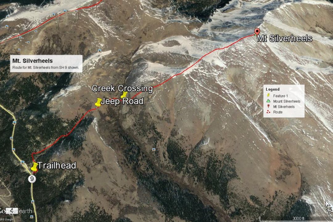
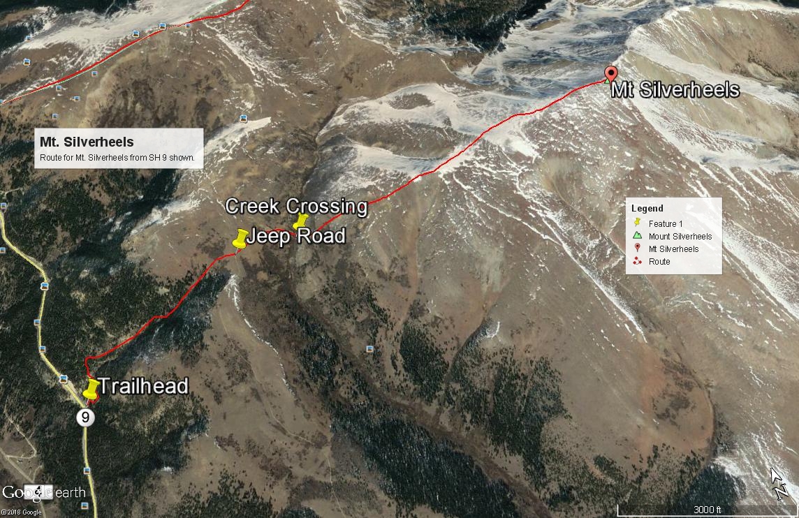
The summit of Hoosier Pass is the trailhead for North Star Mountain, Hoosier Ridge and Red Mountain. The pass is located on State Highway 9. The trailhead for Mt. Silverheels is either 2.3 miles south of the pass on SH 9 or 2.85. There is a pullout on the east side of the highway at that location with a single-track road heading off up the hillside. A few yards north on the highway, there is a larger parking area on the west side. This is the second major drainage the highway crosses south of the Hoosier Pass summit. The small stream is unnamed on the USGS map. Roach refers to it as "South Scott Gulch." In case there is a mileage difference, the coordinates for the pullout are: N 39° 20' 05.16" W 106° 03' 04.23". Recent reports to us indicate that this old road access is now closed and marked for Private Property. If so, an alternate start is another .4 mile down from the pass towards Alma. See the Mt. Silverheels route description for further details regarding this alternate start.
From I-70, westbound or eastbound, take exit 203 or 201 for Frisco. From Frisco, continue southbound on SH 9 to Breckenridge. Continue on through Breckenridge past Goose Pasture Tarn and Blue River to the summit of Hoosier Pass where there is usually ample parking on the west side of the highway.
From the south, State Highway 9 can be picked up at Fairplay from US 285. Drive north on SH 9 through Fairplay, then Alma. (Watch for speed traps. The speed limits are rigidly enforced.) North of Alma, the highway begins its ascent to Hoosier Pass in earnest. The trailhead for Mt. Silverheels will come before arriving at the summit of Hoosier Pass. See coordinates above or see the Mt. Silverheels route description. For the other summits, accessed from the top of the pass, park just off the highway on the west side. In summer months there are usually numerous vehicles stopped here from out of state visitors taking in the view and gasping for air.
Camping
On the west side of the highway at the top of the pass there are several informal campsites (no facilities) that have evolved over the years. Enough for a half dozen campers or so. You'll just have to put up with some highway noise. Last time we used one of these sites was in 2013. This area has become well-known and typically full, especially on weekends. We would not be surprised to see the Forest Service or some other governing agency shut it down some day.
There are Forest Service, fee campgrounds in South Park, south and west of Fairplay. These are the Fourmile CG and the Horseshoe CG, both located on CR 18 that heads up toward Mt. Sherman. If you want camping information around the Dillon/Frisco area, see the link below. You can also find limited and not very private places to park and car camp on the north side of Hoosier Pass. Try CR850/Blue Lakes Road up to the lower lake or CR851/McCullough Gulch Road to the end of the road, past all the parking for Quandary Peak. Do not expect to find an available spot here on a summer weekend however, from all the climber traffic heading for Quandary. Otherwise, continued private development throughout this area has made at-large camping mostly a thing of the past.
Route Description
Year Climbed: 1989Notice: As of 07/2018, it has been reported to us that the one-lane road we suggest hiking up in the paragraph below has been posted with "No Trespassing" signs. We therefore suggest using the alternate trailhead/approach suggested in the final paragraph below, which begins in the town of Fairplay.
The "Guide To the Colorado Mountains" reports that Mt. Silverheels is named after a dance hall girl that nursed miners through a smallpox epidemic. Might be an interesting story there.
Having parked at the pullout provided on the trailhead directions, head up the one-lane road which will switchback a couple times, head north to cross the drainage, then wind its way to a small reservoir at N 39° 20' 13.66" W 106° 02' 57.71". From the reservoir, follow the drainage east uphill to crest out on Beaver Ridge. If you stay on the north side of the drainage, the trees are more open. As you near the top, there will be some willows to work through, but there's an easy break in them to reach the Forest Service road #659. Coordinates for the road are: 39° 20' 22.20" W 106° 02' 13.97".
Alternate Access: Drive down from Hoosier Pass toward Alma another .3 - .4 mile and watch for a minor drainage that comes down from a steep slope on the east side of the highway. Coordinates: N 39° 19' 47.72" W 106° 03' 07.14" Park where possible and head up this drainage a short distance, then veer out of the drainage to the SE working through trees that should be opening up. Continue SE until you reach more open meadow with sparse trees. Turn east and continue up steeply to reach Beaver Ridge and FR 659 described above. Follow the road north to intercept the coordinates in the previous paragraph.
Head north up the road a little and cross under the power lines to drop down to cross Beaver Creek. You will lose almost 300 feet in elevation. (That's the one drawback about this route.) Aim for these coordinates for the easiest crossing that gets you through the willows: N 39° 20' 22.71" W 106° 01' 56.13". Elev. 11,750 ft. On the east side of the creek, if you cross at this location, the willows will be at a minimum. Once across, just head on up the west slope/ridge and follow it all the way to the summit. This slope/ridge is mostly tundra/grass with mild amounts of scree and smaller rubble. The summit is rocky and has a large rock shelter to break the wind. As with most peaks in this area, expect some wind.
Alternate access for stock 4WD or higher clearance crossover type vehicles: From SH 9 in Fairplay turn NE onto 4th Street and drive 4 blocks to a left turn onto Beaver Ck. Lane. Take Beaver Ck. Lane a couple miles to a right hand turn onto FS 413. Go east to a Forest Service gate at mile 2.3 then north of FS 659. This access takes you past a cattle guard crossing and the Fairplay Nordic Center. FS 659 leads north and gains Beaver Ridge, leading to the same coordinates provided in the first paragraph above for where the route coming in from SH 9 would meet this road. We have not personally driven FS 659. It is reported to be a good road for stock 4WD and crossovers with good ground clearance. Please note that on Google Earth, this road is mis-identified as FS 655.
Additional BETA
Links to other information, routes & trip reports for this peak that may be helpful. -