LoJ: #502 (Pre-LiDAR #495) / 13,173' Mount Valois
Range ›
San Juan Range
Quadrangle ›
Columbine Pass
Summit Location ›
 N 37° 34' 26.47", W 107° 35' 04.52"
(Not Field Checked)
N 37° 34' 26.47", W 107° 35' 04.52"
(Not Field Checked)
Neighboring Peaks ›
Aztec Mountain
Peak Summary
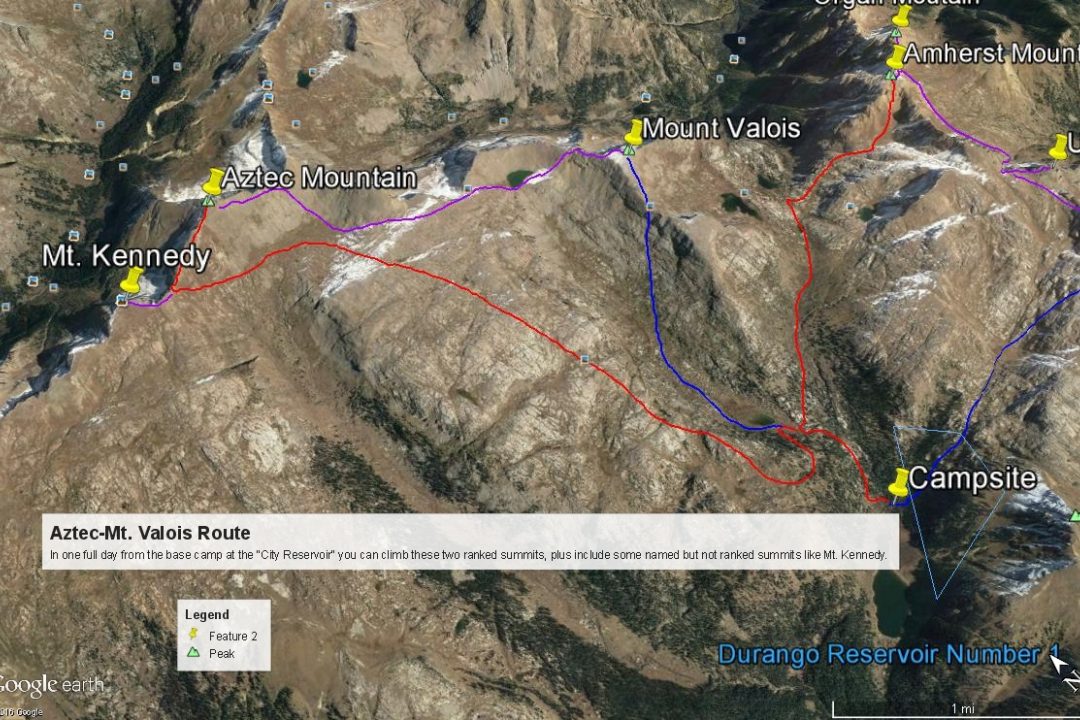
Mount Valois is a Class 2+ ascent which we have sequenced with Aztec Mountain for a moderately long day hike from a base camp at the Durango Reservoir #1. Our suggested trip includes a backpack trip up the Endlich Mesa trail out of Durango. A vehicle with good ground clearance is required to access the trailhead, though rugged 4WD is not necessary. This suggested backpack/climbing trip can net six ranked 13ers over a maximum four day period. Lidar reduced elevation by 12 feet demoting this summit into the top 600.
Mount Valois North Ridge Route
Class 2

Backpack + Medium Day
Climbed with
Aztec Mountain
RT From Endlich Mesa Trailhead:
24.4 mi / 4,925'
RT From
City Reservoir #1
with
Aztec Mountain:
10.4 mi / 3,925'
From Aztec Mountain:
2.60 mi / 1,250' (One-Way)
-
-
Bear Creek/Hunchback Pass/Kite Lake TH
WARNING: This trail head approach REQUIRES 4WD with good ground clearance. The drive as described below from Silverton may take up to 2.5 hours.
From the Town of Silverton, and where the main road splits at the NE end of town, drive 4.2 miles NE up along the Animas River on blue-signed County Road 2 to Howardsville. Turn right onto FR589 up Cunningham Gulch and stay right at the turn for the "Old Mine Tour" (4.4 miles) but do take the left fork toward Stony Pass (FR737) at 5.9miles. Once on the Stony Pass Road, expect 4W conditions. The road climbs steeply to the pass. Abundant wildflowers as you approach the pass may delay you. Once across the pass, the road becomes FR520 and eventually leads to Rio Grande Reservoir, but you will not drive that far. The road eventually descends down the valley to a low water crossing of Pole Creek. There are several primitive campsites on both sides of the Pole Creek crossing. Watch out for the steep embankment climb out on the east side if the road is wet from rains. You could easily slip off the edge. After the crossing, continue south for under a mile to another fork where you'll turn right (west). Another long, low water crossing is found here across the Rio Grande River. This crossing is usually more shallow than the Pole Creek, but the closer you are to runoff season, the more difficult these crossings will be.
It is also possible to come into this area from either Creede or Lake City over Slumgullion and Spring Pass to Rio Grande Reservoir. From state highway 149 either about 20.5 miles from Creede or 32 miles from Lake City, turn west onto FS520 and drive all the way to the reservoir on the well-signed, graded dirt road. Passenger cars can make it all the way to the "Lost Trail Campground" at the far west end of the reservoir. Beyond that point, FR520 continues west and crosses some rugged sections before connecting with the other section of FR520 coming down from Stony Pass and the low-water crossing of the Rio Grande. We have never driven in all the way on this section and from those we know who have, they have complained about one particularly difficult stretch.
From the Rio Grande crossing, continue up what is now, the Beartown Road for a slow 4 miles (mainly because of potholes) to the former location of Beartown. (There's really nothing left to see there, but just before the road crosses Bear Creek, beyond the old townsite, there is some good camping. The road goes all the way to Kite Lake at about 12,100 ft., but the Hunchback Pass trailhead is about 1/2 mile below the lake. There's a trail sign there and some very limited parking is available. Road Notes as of 2018: About half the distance toward Beartown, the road crosses an unnamed creek and at that spot, there are some difficult mud/potholes that have really been dug out. Longer bed vehicles may have some difficulty getting through. Take it slow. Closer to Beartown, the road passes through a fence line. At that point, the road conditions will begin to deteriorate and become more rocky as it begins to gain some elevation.
As the road begins climbing more steeply toward Kite Lake and the Hunchback trailhead, after crossing Bear Creek, it becomes quite a bit more rocky in that stretch as well. For a long section, the road is deeply entrenched in the middle because of runoff and the trench tends to fill with loose rocks. If you have driven in here to do the Ute Ridge group of summits, camp in the vicinity of where the road crosses Bear Creek just past the old Beartown site. See coordinates below. From that creek crossing, it's not quite .3 mile to the trailhead for Ute Ridge, which is a jeep track that turns off to the left and drops down to cross another lesser fork of Bear Creek. Park somewhere along this track if heading for Ute Ridge. On the Caltopo map, this trail is called the "Bear Town Trail" and designated FR869. On trails Illustrated Map #140, it does not appear to have a designation. Coordinates for this road & trailhead are: N 37° 42' 54.53" W 107° 30' 35.00". You can find a good camp spot here as well. You can also find some additional camp spots within a few hundred yards of the Hunchback Pass trailhead. One of those spots goes off to the south to an old mining area.
Camping
You can find some very limited camping spots in the immediate vicinity of the Hunchback trailhead. There's one particularly good spot back down the road a fairly short distance on the south side. There's also some good camping back toward the Beartown site. See coordinates provided.
Campsite Locations
Beartown Campsite › N 37° 43' 05.02", W 107° 30' 35.47"
-
From Endlich Mesa TH via City Reservoir #1 & Aztec Mountain:
-
Aztec Mtn. West Ridge Class 2 / 5.25 mi / 2,675’ One-Way
Open This Route in a New WindowThis route description begins from the end of the Endlich Mesa trail approach which terminates at the NE end of City Reservoir #1 at our suggested camp location. From that campsite, follow trail #534 north as it climbs steeply up the valley toward Lake Marie. Shortly before arriving at that lake, the trail switchbacks to the south, rounds a ridge to the west, then climbs on up onto Silver Mesa. Once atop the mesa, you'll be above timberline. After a while, the trail will tend to fade amidst granite outcrops and was identified at times, only by cairns. We found it easy to wander off it, but would usually find it again. The trial heads mostly north and takes you by the Pittsburg Mine. From there, walk another 3/4 mile NNW to where you can easily overlook the basin south of Aztec. In the lush, green grass below, you may have the opportunity to spot a herd of elk.
From this vantage point, south of the peak, it ma be difficult to determine which "bump" is Aztec Mtn. A GPS could be useful in doing so. We decided the easiest thing to do was to lose about 300 feet I elevation and angle NNW, then west into the basin below and cross the head of it over to a saddle at 12,860 ft. This will be the saddle between Aztec and Mt. Kennedy to the west. Follow mostly grassy slopes to that saddle and if your seasonal timing is right, enjoy some beautiful, blue columbine along the way. At the saddle, you may want to first turn left and make the quick and easy trip up along the ridge to bag Mt. Kennedy. If not, turn right (east) and walk up to the Aztec summit. There will be a minor false summit to bypass and a finish on scree-like rock. The hike from the lakeside campsite may take up to 4 hours.
The most redeeming aspect of climbing Aztec Mountain is the bird's-eye view of Chicago Basin and the three 14ers. The view is quite impressive. From the summit, either return as you came, or head down the east ridge and decide if you want to return to camp or head on for Mount Valois, which could also include a trip over Bullion Mtn. and Florida Mtn, both unranked summits.
-
Route Description
Year Climbed: 2006The route for Mount Valois is sequenced with Aztec Mountain. Elevation gain and mileage are measured from the summit of Aztec to Valois. Our suggested climb begins from a base camp at the Durango City Reservoir #1 which you have backpacked into and set up a base camp. The Aztec-Valois combination makes for a moderately long day hike of nearly 11 miles round trip from the suggested base camp.
From the summit of Aztec Mountain you can walk east along the ridge crest to a saddle between Aztec and Pt.13,190. This is mostly Class 2. "Furthermore" on LoJ makes mention of a few brief 3rd class scrambles. Our notes did not record such. At the saddle, you could continue along the ridge crest and follow it to Pt.13,190, then south to Bullion Mtn., SE to Florida Mtn., then SE to Mount Valois. This long ridge hike would not net any more ranked 13ers. It does not appear too difficult except the Bullion Mtn. stretch which appears to have some difficulties. If the weather permits, you may want to consider this route to Mount Valois. The day we hiked these peaks, by the time were heading off of Aztec, we were dodging lightening bolts, so it seemed prudent to take a safer route over to Valois that kept us off exposed ridges.
So, from the Aztec-Pt.13,190 saddle, drop south on scree at first that turns to tundra lower down. Drop into the basin west of and below Bullion Mtn. to about 12,400 ft. Turn SE, then east toward Trimble Pass, regaining nearly 600 hundred feet in elevation over mostly tundra terrain with some rocky outcrops and rubble thrown in. Follow similar terrain down to Lillie Lake, below Florida Mountain, losing about 300 feet in elevation. At Trimble Pass, you'll intersect a trail that leads north into Vallecito Basin at the head of Johnson Creek. This trail will lead for a short distance down to Lillie Lake, but you'll have to depart it to reach the lake.
From Lillie Lake, begin hiking up a low ridge that drops down to Lillie Lake, descending off the north ridge of Valois. This ridge quickly becomes very rocky. Head for a prominent notch on the north ridge. Contour south to gain the north ridge at whatever point footing allows you. Gaining this notch and following the ridge south until you hit the wide, flat summit plateau is a frustrating Class 2+ scramble across a multitude of boulders with very insecure footing. This will be the only really difficult part of the day. If the rocks are wet from rain, they will be treacherous. Once on the summit plateau, it's a stroll to the high point which is located near the beginning of the east ridge of Valois. On a clearer day, you'll have good views toward Amherst and Organ, and the impressive peaks above Johnson Creek tot he north.
After visiting the summit, the most direct and easiest way back to camp is to walk down the mostly tundra ridge a short ways to the south toward a saddle between Valois and Pt.12,954. Watch for a break in the cliffs along the west side of the ridge and when you see a good opportunity to head west and down, do so. Once down through the upper rocks and cliffs, it will be mostly a tundra descent back into "Crystal Valley." Once in the valley bottom, head south to Lake Marie, pick up the trail you followed in the morning and follow it back down to the base camp at City Reservoir #1.
Additional BETA
Links to other information, routes & trip reports for this peak that may be helpful. -

Warning!
Climbing peaks can be dangerous! By using this site and the information contained herein, you're agreeing to use common sense, good judgement, and to not hold us liable nor sue us for any reason. Legal Notice & Terms of Use.