LoJ: #247 (Pre-LiDAR #253) / 13,513' North Arapaho Peak

Peak Summary
Using the half mile long ridge traverse from South Arapaho, North Arapaho offers a fun 3rd Class scramble along a rocky ridge with some exposure. Depending on how you navigate this ridge, you can even encounter some Class 4 moves. The hike is a popular, Front Range destination for peakbaggers/climbers and the trailhead is passenger car accessible if you don't mind a somewhat rocky & bumpy road. Pre-Lidar elevation was 13,502.
South Ridge - N. Arapaho Peak Route
-
-
Fourth of July TH
If coming from the northern Front Range areas or up from Boulder, drive to Nederland and from the traffic circle where the three main roads intersect, drive south on SH119 .7 mile and turn right (west) onto CR130 to Eldora. If coming from the south by way of SH119, this turnoff will be just south of town just after a couple of switchback curves in the highway drop you down to town level. Turn left (west) and drive to Eldora on paved road, passing the high school and the turnoff for the Eldora Ski area. From SH119, it's 1.5 miles to the ski area turnoff. Continue through the town of Eldora where the paved road ends and continue in a NW direction on CR130 to the Fourth of July Trailhead and campground which is about 7.6 more miles. The road becomes progressively rougher but does not necessarily require high clearance or 4WD, but you might be more comfortable with a higher clearance vehicle at least. Especially on weekends, the last half mile or more to the trailhead, you may see numerous cars parked along the road and may have to park some distance away, yourself. On the Trails Illustrated map, after the historical site of Hessie, this upper section of road is labelled CR111/The Fourth of July Road and ends at what the map calls the "Buckingham Trailhead."
There is a small campground and a trailhead parking area above. There's a vault toilet available.
Camping
Other than the small campground at the trailhead, because there's so much private property on the drive in, finding any legal, at-large camp spots is difficult. Expect the campground to be full any time around a weekend. There are about 10 tent spots for use and no water supplied, but there is a vault toilet. No fee is collected for the campground, but that can always change. "No Camping" is signed at the trailhead parking. There is an overnight parking fee. Because of the popularity of this trailhead, expect the parking area to fill up early on weekends.
-
From "Old Baldy" South Arapaho Peak
-
Old Baldy West Ridge Class 2 / 4.15 mi / 2,900’ One-Way
Open This Route in a New WindowFrom the Fourth of July TH, hike up the trail that eventually leads to Arapaho Pass. There is one switchback right at the beginning and then another more pronounced switchback about 1/2 mile up. The trail is well-used, easy to follow and ascends at a fairly gentle gradient. At 1.6 miles up, the trail comes to the Fourth of July mining ruins. (See coordinates provided.) The trail for the Arapaho Peaks turns off in this vicinity and was signed when we passed by in 2012. You may see other trails earlier that serve as a shortcut. Most likely, the Forest Service discourages their use.
From the trail intersection, head up past low trees and onto open tundra slopes. The trail heads NE and E as if climbs steadily on switchbacks through mostly tundra terrain that gives way to more rock higher up. Near the saddle between South Arapaho and "Old Baldy," (UN13,038) the trail joins the "Glacier Trail" coming in from the east.
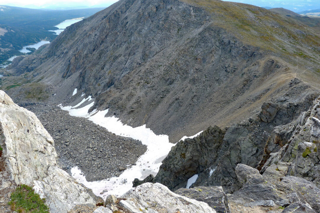
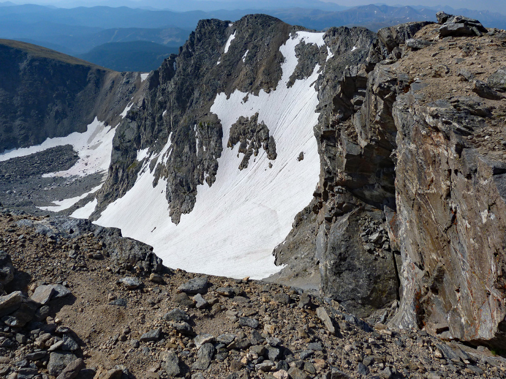
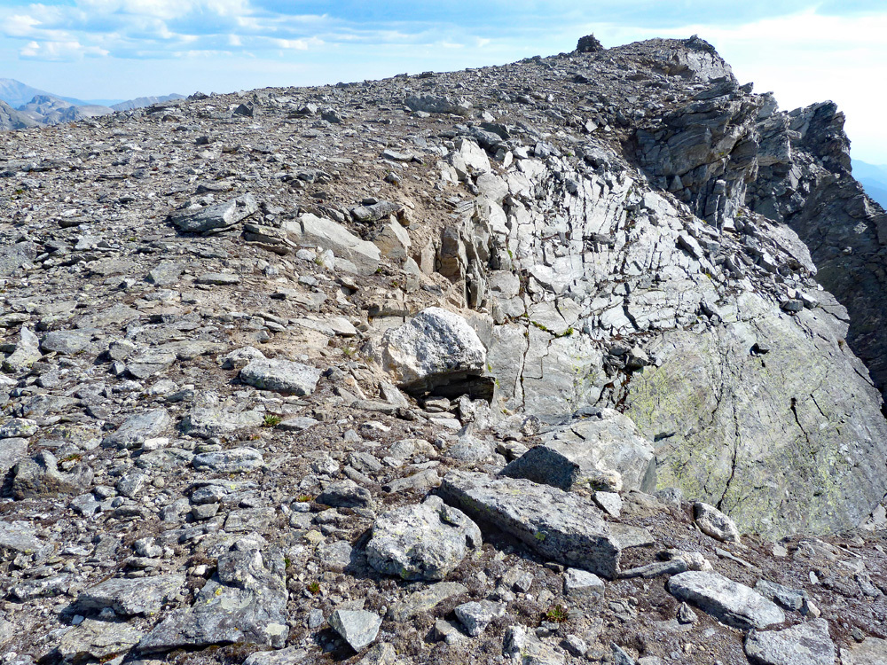
Once at the saddle, walk east mostly on "use trail" along the ridge crest to the summit of Old Baldy over more rocky terrain with boulders. Enjoy the excellent view of the Arapaho Peaks and the cirque below the peaks with the Arapaho Glacier. Return by the same route or descend to the previous saddle and continue to South Arapaho Peak.
-
South Arapaho SE Ridge Class 2 / .9 mi / 700’ One-Way
Click thumbnail to view full-size photo + caption
Open This Route in a New WindowFrom the Fourth of July TH, hike up the trail that eventually leads to Arapaho Pass. There is one switchback right at the beginning and then another more pronounced switchback about 1/2 mile up. The trail is well-used, easy to follow and ascends at a fairly gentle gradient. At 1.6 miles up, the trail comes to the Fourth of July mining ruins. (See coordinates provided.) The trail for the Arapaho Peaks turns of in this vicinity and was signed when we passed by in 2012. You may see other trails earlier that serve as a shortcut. Most likely, the Forest Service discourages their use.
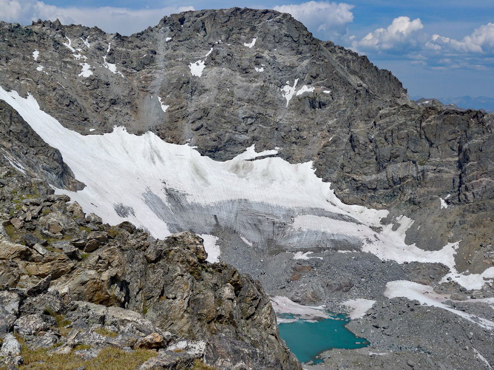
From the trail intersection, head up past low trees and onto open tundra slopes. The trail heads NE and E as if climbs steadily on switchbacks through mostly tundra terrain that gives way to more rock higher up. Near the saddle between South Arapaho and "Old Baldy," (UN13,038) the trail joins the "Glacier Trail" coming in from the east. At the saddle, turn and head NW, basically following along the ridge to the summit. The gradient increases in steepness. There are spectacular views looking down to the right into the Arapaho Glacier cirque. Staying on the trail will keep you safe. Venture near the edge at your own risk. The trail finishes amid boulders & rocks at the summit.
Now it's time to take a good look at the weather and decide if you have the additional two hours minimum to make the traverse on over to North Arapaho and back without putting yourself at too much risk. To descend from S. Arapaho, simply retrace your ascent route back to the TH, but don't forget to include "Old Baldy," which is no more than a 15 minutes jaunt up from the east saddle over mixed tundra & rock.
-
Click thumbnail to view full-size photo + captionRoute Description
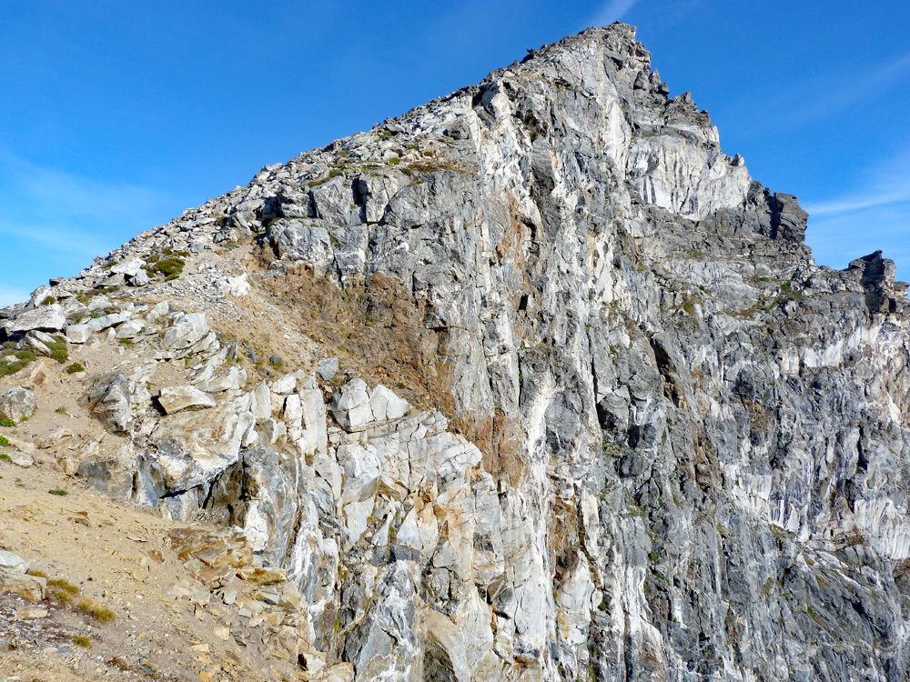
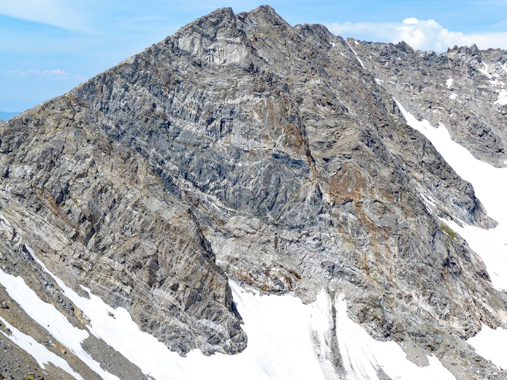
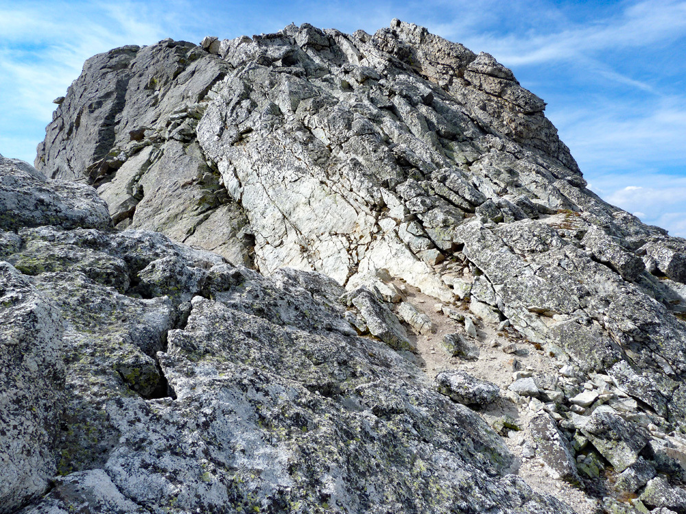
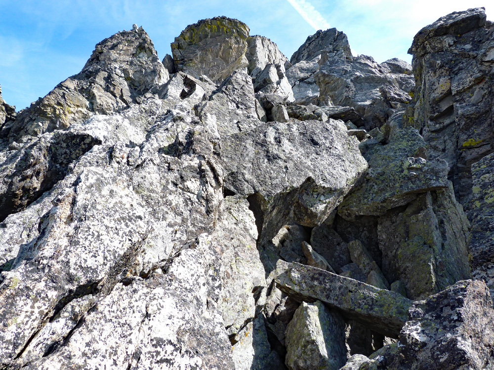
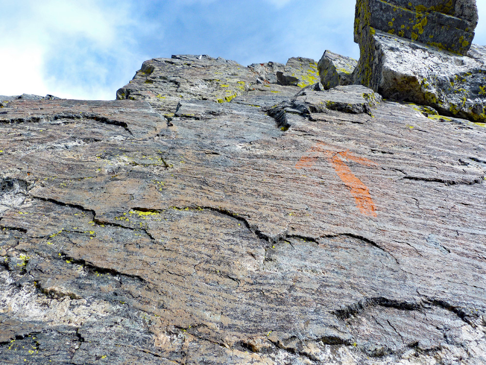
Year Climbed: 1998From the summit of South Arapaho, proceed NW along the ridge crest for about the first third of the distance over to N. Arapaho. You'll enjoy some fine views down into the Arapaho Glacier cirque. This first part goes fairly quickly with no real difficulties. The toughest part is the middle third section. Not knowing about the orange, painted arrows that guide you more along the ridge crest, we began to make a descending contour on the west side of the ridge, passing through several couloirs and losing about 120 ft. Then we made an ascending contour back up to the ridge coming out about 2/3rds of the way across. Once back on the ridge, we worked the east side of the crest a little before finishing the ascent to the summit amid large boulders. The summit itself is relatively flat. There's a huge cairn. Overall, the exposure on the traverse is moderate. The rock is basically stable, but there are always rotten sections and you should never make any assumptions. The painted arrows are there and some report finding them easily while others miss many as we did. There are multiple "use" trails and cairns, and probably more now than when we did it. From the summit, you can see the forbidden fruits of Arikaree and Kiowa Peaks to the north, in the Boulder Watershed. The overall view is quite spectacular and has a very "alpine" feel to it.
If electing to stay more on the ridge crest, there will be a semi-gendarme to scramble over that some rate as 4th Class in the middle section. Beyond it, there are two more that can be skirted below. Even trying to stay on the ridge, you may find yourself forced down. Overall, the route across is too complex to describe, but experienced peakbaggers should not need a "hold-your-hand" description to figure this out. Plan on an hour to make this traverse. If you choose the correct route across, rope should not be necessary (but a short back-up piece in your pack is never a bad idea when getting onto this kind of terrain).
Once atop North Arapaho, the most reasonable return is back as you came. Be sure and tag UN13,038 on you way back. It's only a 15 minute easy walk from the saddle east of South Arapaho.
Additional BETA
Links to other information, routes & trip reports for this peak that may be helpful. -